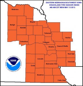
The National Weather Service in Valley, NE, says today’s Grassland Fire Danger Category in eastern Nebraska and southwest Iowa, is Very High. The next two days will be hot and dry, leaving conditions for rapid fire development extremely high. If you plan to burn remember to plan ahead and take all necessary precautions as winds and low humidity levels will create conditions for fast and out of control fires.
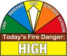
The Shelby County Emergency Management Agency says due to forecast low relative humidity and high wind conditions, along with the presence of dry fine fuels, the fire danger rating in the County is being upgraded to HIGH. Controlled burns should be avoided for the next couple of days. Notify your local fire chief if outdoor burning is planned.
Officials are asking participating agencies to place their “Fire Danger” signs in the High category. The rating will be re-evaluated on Thursday, May 16th, or before as conditions dictate.
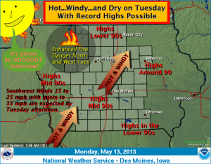
An impressive warming trend remains certain across Iowa today into Tuesday. The warmest day is forecast on Tuesday where near record or record high temperatures are anticipated. Lower to middle 90s for highs will be common over central Iowa. Windy southwest winds and very dry relative humidity will lead to an enhanced fire danger over western and northern Iowa Tuesday afternoon. A cold front will sweep across the state Tuesday night and provide a slight chance of thunderstorms. Cooler temperatures are expected by Wednesday.
The Freese-Notis (podcast) forecast for Atlantic & the KJAN listening area, and weather data for Atlantic…
Podcast: Play in new window | Download (968.0KB)
Subscribe: RSS
400 AM CDT MON MAY 13 2013
…NEAR RECORD HIGHS TUESDAY…
EARLY THIS MORNING…PARTLY CLOUDY. SOUTH WIND NEAR 5 MPH.
TODAY...PARTLY SUNNY. BREEZY…WARMER. HIGH IN THE UPPER 70S. SOUTH WIND 5 TO 15 MPH INCREASING TO 15 TO 20 MPH WITH GUSTS TO AROUND 30 MPH IN THE AFTERNOON.
TONIGHT…MOSTLY CLEAR. WARMER. LOW IN THE UPPER 50S. SOUTHWEST WIND 5 TO 15 MPH. GUSTS UP TO 25 MPH THROUGH MIDNIGHT.
TUESDAY…MOSTLY SUNNY. HOT…BREEZY. HIGH IN THE MID 90S. SOUTHWEST WIND 5 TO 15 MPH INCREASING TO 15 TO 20 MPH IN THE
AFTERNOON. GUSTS UP TO 30 MPH.
TUESDAY NIGHT…PARTLY CLOUDY WITH A 20 PERCENT CHANCE OF THUNDERSTORMS. LOW IN THE LOWER 60S. NORTHWEST WIND 5 TO 15 MPH. GUSTS UP TO 25 MPH THROUGH MIDNIGHT.
WEDNESDAY…PARTLY SUNNY. NOT AS WARM. HIGH IN THE UPPER 70S. NORTH WIND 5 TO 10 MPH.
WEDNESDAY NIGHT…PARTLY CLOUDY WITH A 20 PERCENT CHANCE OF THUNDERSTORMS. LOW IN THE UPPER 50S.
THURSDAY…MOSTLY CLOUDY WITH A 30 PERCENT CHANCE OF THUNDERSTORMS. HIGH IN THE UPPER 70S.
310 PM CDT SUN MAY 12 2013
THIS HAZARDOUS WEATHER OUTLOOK IS FOR PORTIONS OF THE KJAN LISTENING AREA, INCLUDING THESE COUNTIES...
SAC-CRAWFORD-CARROLL-GREENE-AUDUBON-GUTHRIE-DALLAS-CASS-ADAIR-MADISON-ADAMS-UNION-TAYLOR-RINGGOLD
THIS AFTERNOON AND TONIGHT: NO HAZARDOUS WEATHER IS EXPECTED AT THIS TIME.
MONDAY THROUGH SATURDAY: ON TUESDAY SOUTHWEST WINDS WILL INCREASE TO 20 TO 30 MPH AT TIMES WITH RELATIVE HUMIDITY FALLING TO AROUND 30 PERCENT IN THE AFTERNOON. THIS WILL RESULT IN AN ENHANCED FIRE DANGER…ESPECIALLY ACROSS NORTHERN AND WESTERN IOWA.
LOW THUNDERSTORM CHANCES WILL RETURN TO THE FORECAST AT TIMES BETWEEN TUESDAY NIGHT AND THURSDAY…MAINLY SOUTH OF HIGHWAY 20. THERE IS A LOW SEVERE WEATHER THREAT DURING THIS TIME FRAME. THUNDERSTORM CHANCES WILL THEN INCREASE WITH SEVERAL ROUNDS OF STORMS LIKELY FROM LATE THURSDAY THROUGH THE WEEKEND. SEVERE WEATHER CHANCES WILL BE HIGHER AT TIMES DURING THIS PERIOD…BUT THE DETAILS OF THE THREATS ARE STILL UNCLEAR AT THIS RANGE.
.SPOTTER INFORMATION STATEMENT…
SPOTTER ACTIVATION MAY BECOME POSSIBLE BY THE MIDDLE OF NEXT WEEK.
(NWS/Des Moines/8:15-a.m. update)
TODAY…MOSTLY SUNNY. HIGH IN THE LOWER 60S. NORTHWEST WIND NEAR 10 MPH.
TONIGHT…MOSTLY CLEAR. LOW IN THE LOWER 40S. SOUTHWEST WIND NEAR 5 MPH SHIFTING TO THE SOUTH AROUND 5 MPH AFTER MIDNIGHT.
MONDAY…PARTLY SUNNY. WARMER. HIGH IN THE MID 70S. SOUTH WIND 5 TO 15 MPH WITH GUSTS TO AROUND 25 MPH.
MONDAY NIGHT…MOSTLY CLEAR. WARMER. LOW IN THE UPPER 50S. SOUTHWEST WIND 5 TO 15 MPH.
TUESDAY…MOSTLY SUNNY. BREEZY…WARMER. HIGH IN THE LOWER 90S. SOUTHWEST WIND 10 TO 20 MPH. GUSTS UP TO 30 MPH IN THE AFTERNOON.
TUESDAY NIGHT…PARTLY CLOUDY WITH A 20 PERCENT CHANCE OF THUNDERSTORMS. LOW IN THE LOWER 60S.
WEDNESDAY THROUGH FRIDAY…PARTLY CLOUDY WITH A 30 PERCENT CHANCE OF THUNDERSTORMS. HIGH IN THE UPPER 70S. LOW IN THE UPPER 50S.
1016 AM CDT SAT MAY 11 2013
AN AREA OF CANADIAN HIGH PRESSURE WILL SETTLE OVER THE MISSOURI VALLEY BY SUNDAY MORNING. THE COLD AIR ASSOCIATED WITH THE HIGH ALONG WITH CLEAR SKIES AND LIGHT WINDS SHOULD ALLOW FROST TO FORM OVER PARTS OF NORTHERN AND WESTERN IOWA.
AREA COUNTIES: SAC-CRAWFORD-CARROLL-AUDUBON-GUTHRIE-CASS-
…FROST ADVISORY REMAINS IN EFFECT FROM 3 AM TO 9 AM CDT SUNDAY…
* TEMPERATURE…LOWS WILL BE IN THE LOWER 30S.
* IMPACTS…WIDESPREAD FROST WILL THREATEN TENDER VEGETATION IN THE ADVISORY AREA.
PRECAUTIONARY/PREPAREDNESS ACTIONS…
A FROST ADVISORY MEANS THAT FROST IS POSSIBLE. SENSITIVE OUTDOOR
PLANTS MAY BE KILLED IF LEFT UNCOVERED.
URGENT - WEATHER MESSAGE
NATIONAL WEATHER SERVICE DES MOINES IA
402 AM CDT SAT MAY 11 2013
.AN AREA OF CANADIAN HIGH PRESSURE WILL SETTLE OVER THE MISSOURI
VALLEY BY SUNDAY MORNING. THE COLD AIR ASSOCIATED WITH THE HIGH
ALONG WITH CLEAR SKIES AND LIGHT WINDS SHOULD ALLOW FROST TO FORM
OVER PARTS OF NORTHERN AND WESTERN IOWA.
-CRAWFORD-CARROLL-GREENE-AUDUBON-GUTHRIE-CASS-
...FROST ADVISORY IN EFFECT FROM 3 AM TO 9 AM CDT SUNDAY...
THE NATIONAL WEATHER SERVICE IN DES MOINES HAS ISSUED A FROST
ADVISORY...WHICH IS IN EFFECT FROM 3 AM TO 9 AM CDT SUNDAY.
* TEMPERATURE...LOWS WILL BE IN THE LOWER 30S.
* IMPACTS...WIDESPREAD FROST WILL THREATEN TENDER VEGETATION IN
THE ADVISORY AREA.
PRECAUTIONARY/PREPAREDNESS ACTIONS...
A FROST ADVISORY MEANS THAT FROST IS POSSIBLE. SENSITIVE OUTDOOR
PLANTS MAY BE KILLED IF LEFT UNCOVERED.
SKYSCAN FORECAST SATURDAY MAY 11, 2013
Today: Sunny, with a high near 59. Windy, with a northwest wind 10 to 15 mph increasing to 15 to 25 mph in the morning. Winds could gust as high as 30 mph.
Tonight: Areas of frost after 1am. Otherwise, mostly clear, with a low around 32. North northwest wind 5 to 15 mph, with gusts as high as 20 mph.
Sunday: Areas of frost before 8am. Otherwise, sunny, with a high near 64. Calm wind becoming west northwest 5 to 10 mph in the afternoon.
Monday: Mostly sunny, with a high near 78. South wind 5 to 15 mph, with gusts as high as 20 mph.
Tuesday: Sunny, with a high near 91.
Podcast: Play in new window | Download (657.7KB)
Subscribe: RSS