
Yesterday’s high was 90 and the low was 60. This day last year the high was 92 and the low was 63. The all-time record high was 101 set in 1988. The record low was 38 in 1902. Sunrise is 5:46 a.m. and sunset is 8:57 p.m.
Today: Patchy fog before 8am. Otherwise, sunny, with a high near 90. Calm wind becoming south 5 to 10 mph.
Tonight: Clear, with a low around 65. Southeast wind around 10 mph.
Tuesday: Sunny, with a high near 89. Southeast wind 10 to 15 mph.
Tuesday Night: Mostly clear, with a low around 63. East southeast wind around 10 mph.
Wednesday: Sunny, with a high near 89. East southeast wind around 10 mph.
Thursday: Sunny, with a high near 88.
Yesterday’s high was 83 and the low was 59. This day last year the high was 93 and the low was 70. The all-time record high was 104 set in 1974. The record low was 42 set in 1900. Sunrise is at 5:45 a.m. and sunset is 8:56 p.m.
Today: Patchy fog before 8am. Otherwise, mostly cloudy through mid morning, then gradual clearing, with a high near 82. West northwest wind 5 to 7 mph.
Tonight: Mostly clear, with a low around 62. West wind 5 to 7 mph becoming southeast in the evening.
Tomorrow: Sunny, with a high near 91. South southeast wind 5 to 10 mph.
Tuesday: Sunny, with a high near 89. Southeast wind 9 to 14 mph, with gusts as high as 20 mph.
Wednesday: Mostly sunny, with a high near 89.
Saturday’s High in Atlantic was 87. The Low was 60. We received .43″ rain Saturday, at the KJAN Studios. Last year on this date, the High in Atlantic was 92, and the Low was 70. The Record High for June 18th in Atlantic, was 98 in 1910. The Record Low was 46, in 1974 & 2000.
Today: Widespread haze between 7am and noon. Mostly sunny, with a high near 87. East wind 6 to 10 mph.
Tonight: A 20 percent chance of showers and thunderstorms after 3am. Partly cloudy, with a low around 62. East southeast wind around 8 mph.
Saturday: Showers and thunderstorms, mainly after 1pm. High near 84. South wind 9 to 11 mph. Chance of precipitation is 80%. New rainfall amounts between a quarter and half of an inch possible.
Saturday Night: Showers and thunderstorms likely before 10pm, then showers likely and possibly a thunderstorm between 10pm and 1am, then a chance of showers and thunderstorms after 1am. Mostly cloudy, with a low around 60. South southwest wind 6 to 8 mph. Chance of precipitation is 70%. New rainfall amounts between a tenth and quarter of an inch, except higher amounts possible in thunderstorms.
Sunday: A 40 percent chance of showers and thunderstorms. Mostly sunny, with a high near 83. New rainfall amounts of less than a tenth of an inch, except higher amounts possible in thunderstorms.
Monday: Sunny, with a high near 87.
Thursday’s High in Atlantic was 89. The Low was 55. Last year on this date, the High in Atlantic was 89, and the Low was 62. The Record High on this date in Atlantic, was 103 in 1946. The Record Low was 42 in 1974. Sunrise today: 5:45; Sunset: 8:56.
Today: Mostly sunny, with a high near 89. West southwest wind around 6 mph.
Tonight: Partly cloudy, with a low around 61. South wind around 6 mph becoming east after midnight.
Friday: Mostly sunny, with a high near 89. East wind around 7 mph.
Friday Night: A 30 percent chance of showers and thunderstorms, mainly after 1am. Partly cloudy, with a low around 63. East southeast wind 7 to 9 mph.
Saturday: Showers and thunderstorms likely, mainly after 1pm. Partly sunny, with a high near 84. Chance of precipitation is 60%. New rainfall amounts between a tenth and quarter of an inch, except higher amounts possible in thunderstorms.
Saturday Night: Showers and thunderstorms likely, mainly before 4am, then showers likely and possibly a thunderstorm after 4am. Mostly cloudy, with a low around 60. Chance of precipitation is 70%.
Sunday: A 50 percent chance of showers and thunderstorms. Partly sunny, with a high near 80.
Wednesday’s High in Atlantic was 88. The Low was 53. Last year on this date, the High in Atlantic was 77 and the Low was 59. The Record High was 99 in 1918, and the Record Low was 40 in 1906 & 1969. Sunrise is at 5:45. Sunset is at 8:56.
(Radio Iowa) – There’s smoke over Iowa again from the Canadian wildfires, but National Weather Service Meteorologist, Brad Small says that smoke is high up and not causing problems. “We’ve seen a little bit over northwest and west-central Iowa in the midday here. It’s much worse to our north however from the eastern Dakotas into Minnesota it’s actually getting down to the surface there where we’ve had visibility dropped to a few miles in places,” Small says. He says a variety of factors impact how low the smoke hangs in the air.
“Smoke density wind speed thermodynamic properties of the atmosphere all come into play it’s fairly rare to get smoked down to the surface this far removed from the fires down here in Iowa,” Small says, “but it can’t happen and hopefully in this case it’s all stay to our north and northeast.” Small says the smoke issues were bigger in New York and other eastern states recently because they are closer to the source. He says things could change in Iowa.
“The biggest concerns that looks like for the next couple of days are going to be northeast of us, the smoke might get down to the surface in far northeast Iowa,” he says. Small says the rest of the state shouldn’t see any low hanging smoke.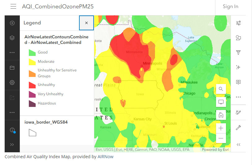 The D-N-R’s air quality measurements show air quality concerns only in a small area in the northwest and southwest corners of the state.
Today: Mostly sunny, with a high near 86. West wind around 6 mph.
Tonight: Partly cloudy, with a low around 59. Southwest wind around 6 mph.
Tomorrow: Sunny, with a high near 89. Southwest wind 3 to 8 mph.
Friday: Mostly sunny w/a 30% chance of showers and thunderstorms in the afternoon. High near 87.
Friday Night: A 50% chance of showers and thunderstorms. Low around 63.
Saturday: A 60% chance of showers and thunderstorms, otherwise partly sunny, with a high near 82.
Tuesday’s High in Atlantic was 84. The Low was 57. Last year on this date, the High in Atlantic was 96 and the Low was 66. The Record High was 97in 1987, and the Record Low was 41in 1933. Sunrise is at 5:45. Sunset is at 8:55.


