
The Freese-Notis weather forecast for the KJAN listening area, and weather data for Atlantic.

Podcast: Play in new window | Download (1.0MB)
Subscribe: RSS
347 AM CDT FRI MAY 9 2014
EARLY THIS MORNING…MOSTLY CLOUDY. BREEZY. MUCH COLDER. NORTHWEST WIND 10 TO 20 MPH WITH GUSTS TO AROUND 30 MPH.
TODAY…PARTLY SUNNY UNTIL LATE AFTERNOON THEN CLEARING. COOLER. HIGH IN THE MID 60S. WEST WIND 10 TO 15 MPH.
TONIGHT…PARTLY CLOUDY. LOW AROUND 50. SOUTHWEST WIND 5 TO 10 MPH SHIFTING TO THE SOUTH AFTER MIDNIGHT.
SATURDAY…PARTLY SUNNY. A CHANCE OF LIGHT SHOWERS AND ISOLATED THUNDERSTORMS IN THE MORNING…THEN A CHANCE OF THUNDERSTORMS IN THE AFTERNOON. WARMER. HIGH IN THE UPPER 70S. SOUTH WIND 5 TO 15 MPH WITH GUSTS TO AROUND 25 MPH. CHANCE OF PRECIPITATION 30 PERCENT.
SATURDAY NIGHT…PARTLY CLOUDY THROUGH MIDNIGHT THEN BECOMING MOSTLY CLOUDY. A 20 PERCENT CHANCE OF THUNDERSTORMS. LOW IN THE MID 50S. WEST WIND 5 TO 10 MPH SHIFTING TO THE NORTH AFTER MIDNIGHT.
SUNDAY…MOSTLY CLOUDY WITH A 50 PERCENT CHANCE OF THUNDERSTORMS. HIGH IN THE UPPER 60S. NORTHEAST WIND 5 TO 15 MPH.
SUNDAY NIGHT…LIGHT SHOWERS LIKELY AND ISOLATED THUNDERSTORMS. LOW IN THE LOWER 50S. CHANCE OF PRECIPITATION 60 PERCENT.
MONDAY…LIGHT SHOWERS LIKELY. BREEZY. HIGH IN THE LOWER 60S. CHANCE OF SHOWERS 60 PERCENT.
THE NATIONAL WEATHER SERVICE HAS CANCELLED TORNADO WATCH 130 FOR THE FOLLOWING AREAS: IN IOWA THIS CANCELS 2 COUNTIES… POTTAWATTAMIE and SHELBY. THIS INCLUDES THE CITIES OF…COUNCIL BLUFFS AND HARLAN.
TORNADO WATCH 130 REMAINS IN EFFECT UNTIL 900 PM CDT FOR THE FOLLOWING COUNTIES IN THE KJAN LISTENING AREA….
ADAIR ADAMS AUDUBON CARROLL CASS CRAWFORD DALLAS GUTHRIE MADISON MONTGOMERY RINGGOLD SAC TAYLOR UNION.
525 PM CDT THU MAY 8 2014
THE NATIONAL WEATHER SERVICE IN DES MOINES HAS ISSUED A TORNADO WARNING FOR…NORTHERN GUTHRIE COUNTY IN WEST CENTRAL IOWA… UNTIL 600 PM CDT
* AT 525 PM CDT…A SEVERE THUNDERSTORM CAPABLE OF PRODUCING A TORNADO WAS LOCATED 7 MILES WEST OF GUTHRIE CENTER…MOVING NORTHEAST AT 35 MPH.
HAZARD…TORNADO…QUARTER SIZE HAIL AND 60 MPH WIND GUSTS.
SOURCE…RADAR INDICATED ROTATION.
IMPACT…FLYING DEBRIS WILL BE DANGEROUS TO THOSE CAUGHT WITHOUT SHELTER. MOBILE HOMES WILL BE DAMAGED OR DESTROYED. DAMAGE TO ROOFS…WINDOWS AND VEHICLES WILL OCCUR. TREE DAMAGE IS LIKELY.
* LOCATIONS IMPACTED INCLUDE…
GUTHRIE CENTER…LAKE PANORAMA…BAYARD…BAGLEY…YALE… JAMAICA…LAKIN SLOUGH GAME MANAGEMENT AREA AND SPRINGBROOK STATE PARK.
PRECAUTIONARY/PREPAREDNESS ACTIONS…
THIS TORNADO WARNING REPLACES THE SEVERE THUNDERSTORM WARNING ISSUED FOR THE SAME AREA.TAKE COVER NOW! MOVE TO A BASEMENT OR AN INTERIOR ROOM ON THE LOWEST
FLOOR OF A STURDY BUILDING. AVOID WINDOWS. IF IN A MOBILE HOME…A
VEHICLE OR OUTDOORS…MOVE TO THE CLOSEST SUBSTANTIAL SHELTER AND
PROTECT YOURSELF FROM FLYING DEBRIS.
BULLETIN – IMMEDIATE BROADCAST REQUESTED
SEVERE THUNDERSTORM WARNING
NATIONAL WEATHER SERVICE DES MOINES IA
519 PM CDT THU MAY 8 2014
THE NATIONAL WEATHER SERVICE IN DES MOINES HAS ISSUED A
* SEVERE THUNDERSTORM WARNING FOR…NORTHEASTERN AUDUBON COUNTY IN WEST CENTRAL IOWA…NORTHWESTERN GUTHRIE COUNTY IN WEST CENTRAL IOWA…SOUTHWESTERN GREENE COUNTY IN WEST CENTRAL IOWA…* UNTIL 600 PM CDT
* AT 519 PM CDT…A SEVERE THUNDERSTORM WAS LOCATED 10 MILES EAST OF AUDUBON…MOVING NORTHEAST AT 35 MPH.
HAZARD…60 MPH WIND GUSTS AND QUARTER SIZE HAIL.
SOURCE…RADAR INDICATED.
IMPACT…HAIL DAMAGE TO VEHICLES IS EXPECTED. EXPECT WIND DAMAGE TO ROOFS…SIDING AND TREES.
* LOCATIONS IMPACTED INCLUDE…JEFFERSON…GUTHRIE CENTER…COON RAPIDS…LAKE PANORAMA…SCRANTON…BAYARD…BAGLEY…YALE…JAMAICA…LAKIN SLOUGH GAME MANAGEMENT AREA AND SPRINGBROOK STATE PARK.
PRECAUTIONARY/PREPAREDNESS ACTIONS…
A TORNADO WATCH REMAINS IN EFFECT FOR THE WARNED AREA. TORNADOES CAN DEVELOP QUICKLY FROM SEVERE THUNDERSTORMS. ALTHOUGH A TORNADO IS NOT IMMEDIATELY LIKELY…IF ONE IS SPOTTED…ACT QUICKLY AND MOVE TO A PLACE OF SAFETY INSIDE A STURDY STRUCTURE…SUCH AS A BASEMENT OR SMALL INTERIOR ROOM. FOR YOUR PROTECTION MOVE TO AN INTERIOR ROOM ON THE LOWEST FLOOR OF A BUILDING.
SAC-CRAWFORD-CARROLL-AUDUBON-GUTHRIE-DALLAS-CASS-ADAIR-MADISON-ADAMS-UNION-TAYLOR-RINGGOLD COUNTIES
432 PM CDT THU MAY 8 2014
A FRONTAL BOUNDARY WILL PUSH EASTWARD ACROSS IOWA. AHEAD OF THE BOUNDARY WINDS WILL REMAIN STRONG AND GUSTY THROUGH THE LATE AFTERNOON HOURS. WINDS OF 20 TO 25 MPH ARE POSSIBLE WITH GUSTS AS HIGH AS 40 MPH AT TIMES. LOOSE OBJECTS MAY BLOW AROUND…AND TRAVELERS MAY EXPERIENCE DIFFICULTY…ESPECIALLY ON EAST AND WEST ROUTES.
210 PM CDT THU MAY 8 2014
SHELBY IA-MILLS IA-HARRISON IA-POTTAWATTAMIE IA
AT 208 PM CDT…DOPPLER RADAR WAS TRACKING A STRONG THUNDERSTORM NEAR PAPILLION…OR 10 MILES SOUTH OF OMAHA…MOVING NORTHEAST AT 45 MPH. ADDITIONAL THUNDERSTORMS ARE EXPECTED TO DEVELOP THROUGH 300 PM OVER EASTERN PARTS OF THE METRO AREA INTO WESTERN IOWA.
HALF INCH HAIL AND WINDS IN EXCESS OF 40 MPH WILL BE POSSIBLE WITH THIS STORM.
LOCATIONS IMPACTED INCLUDE…
OMAHA…COUNCIL BLUFFS…BELLEVUE…PAPILLION…LA VISTA…RALSTON… MISSOURI VALLEY…LOGAN…SPRINGFIELD…UNDERWOOD…MINDEN…CEDAR CREEK…MILLARD…OFFUTT AFB…CARTER LAKE…NEOLA…BOYS TOWN… CRESCENT…MCCLELLAND AND LAKE MANAWA STATE PARK.
THIS STORM MAY INTENSIFY…SO BE CERTAIN TO MONITOR LOCAL RADIO AND TV STATIONS…AS WELL AS LOCAL CABLE TV OUTLETS…FOR ADDITIONAL INFORMATION AND POSSIBLE WARNINGS FROM THE NATIONAL WEATHER SERVICE.
A TORNADO WATCH REMAINS IN EFFECT UNTIL 900 PM CDT THURSDAY EVENING
FOR .
The Severe Storms Prediction Center in Norman, OK. has issued a TORNADO WATCH, which is in effect until 9-p.m. for the following area Counties: ADAIR ADAMS AUDUBON CARROLL CASS CRAWFORD DALLAS GUTHRIE HARRISON MADISON MONONA MONTGOMERY POTTAWATTAMIE RINGGOLD SAC SHELBY TAYLOR and UNION.
COUNTIES: MONONA-HARRISON-SHELBY-POTTAWATTAMIE-MILLS-MONTGOMERY-FREMONT-PAGE-1224 PM CDT THU MAY 8 2014
THIS HAZARDOUS WEATHER OUTLOOK IS FOR PORTIONS OF SOUTHWEST
IOWA…WEST CENTRAL IOWA…EAST CENTRAL NEBRASKA…NORTHEAST
NEBRASKA AND SOUTHEAST NEBRASKA.
.DAY ONE…THIS AFTERNOON AND TONIGHT
THUNDERSTORMS ARE EXPECTED TO DEVELOP EARLY THIS AFTERNOON ALONG A ALONG A COLD FRONT AS IT MOVES INTO EASTERN NEBRASKA…WITH STORMS MOVING NORTHEASTWARD THROUGH EASTERN NEBRASKA AND WESTERN IOWA DURING THE AFTERNOON. SOME OF THESE STORMS MAY BE SEVERE…WITH DAMAGING WINDS AND LARGE HAIL THE MAIN THREATS. AN
ISOLATED TORNADO IS ALSO POSSIBLE…MAINLY IN WESTERN IOWA.
Large hail, damaging winds, and tornadoes are possible across much of Iowa today. National Weather Service Meteorologist Kevin Skow says virtually the entire state is under the gun. “The greatest threat for severe weather extends across most of the central third of Iowa, with the greatest threat for tornadoes and large hail across northern Iowa, and then primarily large hail and some damaging winds across southern Iowa,” Skow says.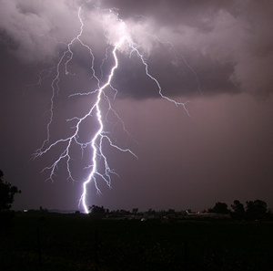
The storms are expected to pop up this afternoon. “It looks like the bulk of the severe weather…will be developing around 2 to 3 p.m. across west-central Iowa and then shifting to the east as the afternoon and evening progress onward,” Skow says.
Storms that rumbled through western and northwest Iowa Wednesday night dropped one-inch diameter hail 8-miles south of Logan in Harrison County, at around 8:53-p.m., and featured winds of up to 55-miles per hour. The storms moved into Carroll County, where winds along Highway 30 were clocked at 64-miles per hour (by the Iowa DOT’s weather station), at around 10:30-p.m.. And, in Sac County, golf ball-sized hail fell just north/northwest of Lytton at around 10-p.m.
High temperatures today are forecast to be between 75 and 85 degrees. Skow says it’ll cool off more tomorrow (Friday). “We’re looking at generally cooler temperatures with a dry start to the weekend, but it looks like showers and thunderstorms return to the forecast on Sunday,” Skow says.
High temperatures on Friday, Saturday, and Sunday are expected to be mainly in the 60s and 70s.
(Radio Iowa)


