
Today: Mostly cloudy w/a 60% chance of late day showers & thunderstorms. High 73. South southwest wind 10 mph becoming west northwest this afternoon.
Tonight: Cloudy & breezy w/a 40% chance of showers and thunderstorms. Low around 62. NW @ 15-25 mph.
Monday: Partly sunny w/a slight chance of showers and thunderstorms. High near 77. N/NW @ 10-20.
Tuesday: Mostly sunny, with a high near 78.
Wednesday: Cloudy & breezy w/an 80% chance of showers and possibly a thunderstorm. High near 76.
Saturday’s high was 84 and the low was 63. We received 1.11 inches of rain at the KJAN studios Saturday into early this (Sunday) morning. This day last year the high in Atlantic was 97 and the low was 75. The all-time record high was 105 set in 1930 and the record low was 46 set in 1974 & 1997. Sunrise is at 6:19 a.m. and sunset is 8:32 p.m.
Today: Patchy fog this morning. Mostly cloudy, w/a 20% chance of showers and thunderstorms after 4pm. High near 83. E breeze @ 5-10 mph.
Tonight: Mo.Cldy w/a 40% chance of showers and thunderstorms. Low around 67.
Tomorrow: Partly sunny w/a 30% chance of showers and thunderstorms. High near 83. SE @ 5-10.
Tom. Night: Mo. Cldy w/a 70% chance of showers and possibly a thunderstorm. Low around 64.
Sunday: Mo. Cldy & breezy w/a 60% chance of showers and possibly a thunderstorm. High near 77.
Sunday Night: Mo. Cldy & windy, w/a slight chance of showers and thunderstorms. Low around 60.
Monday: Mostly sunny & breezy, with a high near 77.
Thursday’s High in Atlantic was 84. Our Low this morning (as of 5-a.m.), was 66. Last year on this date, the High in Atlantic was 89, and the Low was 59. The All-time Record High on August 4th in Atlantic was 110 in 1918. The Record Low was 38 in 1978. Sunrise is at 6:17. Sunset is 8:35.
(Radio Iowa) – The latest Drought Monitor report shows a little deterioration in the conditions in the state in the last week. D-N-R hydrologist Tim Hall says that doesn’t reflect the most recent storms. “The rain that came in southern Iowa over the last two days came after the cutoff for the Drought Monitor,” he says. The monitor shows a large part of eastern Iowa has moved from moderate to severe drought. Hall says the rains we’ve had recently will help.
“Over the last month things have remained relatively stable across the state,” he says. “We ended up behind normal for rainfall in July, although we did get more rain in July than we got in June, so that’s good.” Hall says rainfall in mid July did impact the level of drought, but we haven’t seen consistent enough rain yet to get rid of all the concern. “We’re sort of still on the edge of drought that could become much more significant but it hasn’t gotten appreciably worse,” Hall says. He says the recent rains helped with the much needed soil moisture. 
“The other thing that’s working in our favor is that in about another month or so, we’ll get through the peak demand time of the year. So the demand for water will start to drop as we move from August into September. And that certainly helps to preserve whatever waters in the system,” according to Hall. The weather outlook has indicated we could see more rain in August, which would also help the drought situation.
Today: Patchy fog before 9am. Otherwise, mostly cloudy, with a high near 82. East wind 3 to 6 mph.
Tonight: Partly cloudy, with a low around 67. East wind around 6 mph becoming calm in the evening.
Tomorrow: A 40 percent chance of showers and thunderstorms, mainly after 1pm. Partly sunny, with a high near 84. East wind 5 to 7 mph. New rainfall amounts between a tenth and quarter of an inch, except higher amounts possible in thunderstorms.
Saturday: Showers likely and possibly a thunderstorm before 1pm, then a chance of showers and thunderstorms after 1pm. Partly sunny, with a high near 82. Chance of precipitation is 60%. New rainfall amounts between a tenth and quarter of an inch, except higher amounts possible in thunderstorms.
Sunday: Showers likely and possibly a thunderstorm. Mostly cloudy, with a high near 75. Breezy. Chance of precipitation is 60%.
Wednesday’s High in Atlantic was 78. We received .38″ rain. Our Low was 64. Last year on this date, the High in Atlantic was 92, and the Low was 59. The All-time Record High on August 3rd in Atlantic was 107 in 1930. The Record Low was 42 in 1907. Sunrise is at 6:15. Sunset is 8:35.
Special Weather Statement
National Weather Service Des Moines IA
209 AM CDT Thu Aug 3 2023
…Reduced Visibility in Areas of Fog…
What…Areas of fog with visibilities around or under a mile.
Where…Much of Central Iowa.
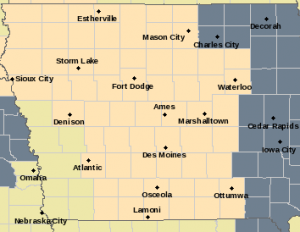
Counties included in the Special Weather Statement are shown in peach/flesh color; Dense Fog Advisory for counties in dark grey.
When…Into the Early Morning Hours Thursday.
Impacts…Drivers should be alert for reduced visibility at times.
Preparedness and Precautionary Actions…If driving overnight into the early morning hours Thursday, please use low beam headlights.
(Radio Iowa) -Many Iowans were awakened by unfamiliar noises this (Wednesday) morning, claps of thunder and raindrops on the rooftop. Some communities that have seen precious little precipitation in weeks — even months — were hit with a deluge. Hydrologist Jeff Zogg, at the National Weather Service, says multiple flash flood warnings were issued early today as rainfall totals reached seven and eight inches in a few locations. “That’s a combination of some radar estimates as well as some rainfall reports that we received,” Zogg says. “The heaviest rainfall fell in a stripe from southwest into south-central Iowa and amounts there were as high as four to six inches with some locally higher amounts.”
Traffic was slowed on many roadways, including Interstate 29 in western Iowa, due to a combination of standing water and a lack of visibility during the downpour. “We’re not hearing a whole lot in terms of major damage from the rainfall,” Zogg says, “mainly just some road closures, maybe some basements with water in them, but in most places, the rainfall was pretty welcome.” The old adage of “When it rains, it pours,” had dual significance today, as drought-stricken areas badly needed the rain, just not quite so much of it over such a short period of time.”The rainfall fell pretty intensely in some locations,” Zogg says, “so while the rainfall was welcome, in some cases it fell a little too fast for it to soak in, and it ran off and caused some of the problems that we were seeing.”
Wide sections of Iowa have been in drought for a few years now, and this precipitation is coming at a crucial time for farmers. “The rainfall that we’ve received will definitely help,” Zogg says. “It won’t end the drought conditions, but as far as for the rest of the day, the chances for showers and storms will be greatest pretty much across the southern half of the state, basically south of Highway 30. It’s kind of winding down in some areas but better chances as you go further south.”
The long-range forecast calls for at least a chance of rain every day through Sunday.
Today: **FLASH FLOOD WARNING for central Cass County (IA) until 11:30-a.m**.; Showers and thunderstorms, mainly before 9am. Some of the storms could produce heavy rainfall. High near 80. SE wind 10-15 mph, with gusts as high as 20 mph.
Tonight: A chance of showers and thunderstorms, mainly after midnight. Low around 69.
Tomorrow: A chance of morning showers and thunderstorms; Partly sunny, with a high near 84. E/NE @ 5-10 mph.
Friday: A chance of showers and thunderstorms, mainly after 1pm. High near 84.
Saturday: Showers & possibly a thunderstorm. High near 80.
Tuesday’s High in Atlantic was 86. Our Low was 68. 24-hour rainfall in Atlantic, ending at 7-a.m. today, amounted to 1.71.” Last year on this date, the High in Atlantic was 95, and the Low was 75. The All-time Record High on August 1st in Atlantic was 103 in 1930. The Record Low was 42 in 1907. Sunrise is at 6:14. Sunset is 8:36.


