
401 AM CDT FRI JUL 4 2014
EARLY THIS MORNING…MOSTLY CLEAR. EAST WIND NEAR 5 MPH.
TODAY…MOSTLY SUNNY. HIGH IN THE LOWER 80S. SOUTH WIND 5 TO 15 MPH.
TONIGHT...PARTLY CLOUDY IN THE EVENING THEN BECOMING MOSTLY CLOUDY. A SLIGHT CHANCE OF THUNDERSTORMS IN THE EVENING…THEN A CHANCE OF THUNDERSTORMS OVERNIGHT. WARMER. LOW IN THE MID 60S. SOUTH WIND 10 TO 15 MPH. CHANCE OF THUNDERSTORMS 50 PERCENT.
SATURDAY…MOSTLY CLOUDY. THUNDERSTORMS LIKELY IN THE MORNING…THEN A CHANCE OF THUNDERSTORMS IN THE AFTERNOON. BREEZY. HIGH IN THE LOWER 80S. SOUTH WIND 10 TO 20 MPH WITH GUSTS TO AROUND 30 MPH. CHANCE OF THUNDERSTORMS 60 PERCENT.
SATURDAY NIGHT…MOSTLY CLOUDY THROUGH MIDNIGHT THEN BECOMING PARTLY CLOUDY. A 20 PERCENT CHANCE OF THUNDERSTORMS. LOW IN THE UPPER 60S. SOUTH WIND 10 TO 15 MPH. GUSTS UP TO 25 MPH THROUGH MIDNIGHT.
SUNDAY…MOSTLY SUNNY. WARMER. HIGH IN THE MID 90S. SOUTHWEST WIND 10 TO 15 MPH. HIGHEST HEAT INDEX READINGS 100 TO 105 IN THE AFTERNOON.
SUNDAY NIGHT…MOSTLY CLOUDY WITH A 40 PERCENT CHANCE OF THUNDERSTORMS. LOW AROUND 70.
MONDAY…MOSTLY SUNNY. HIGH IN THE UPPER 80S.
Wednesday’s High in Atlantic was 70. Our low this (Thursday) morning, 46.
Today -Sunny, with a high near 787. West northwest wind 3 to 5 mph.
Tonight – Mostly clear, with a low around 54. South southeast wind 3 to 5 mph.
Independence Day – Mostly sunny, with a high near 82. Breezy, with a south wind 7 to 17 mph, with gusts as high as 26 mph.
Friday Night- Showers and thunderstorms likely, mainly after 1am. Mostly cloudy, with a low around 65. South southeast wind around 14 mph, with gusts as high as 18 mph. Chance of precipitation is 60%. New rainfall amounts between a tenth and quarter of an inch, except higher amounts possible in thunderstorms.
Saturday – A 40 percent chance of showers and thunderstorms. Partly sunny, with a high near 84. Breezy, with a south wind 13 to 18 mph, with gusts as high as 29 mph. New rainfall amounts between a tenth and quarter of an inch, except higher amounts possible in thunderstorms.
Saturday Night – A 20 percent chance of showers and thunderstorms. Partly cloudy, with a low around 69.
Sunday – Sunny, with a high near 91.
Tuesday’s High in Atlantic was 78. Our low this morning (through 5:15-a.m.) was 56. We had a Trace of rain Tuesday evening in Atlantic and sprinkles early this morning.
(Forecast updated 5:30-a.m.)
Today – Partly to Mo. Sunny w/isolated sprinkles or light rain. High 69. N-NW @ 10-15,
Tonight – Mostly clear. Low 47. North wind 5 to 10 mph becoming calm in the evening.
Thursday – Partly Sunny. High near 77. Winds becoming W-SW @ 5 mph.
Thu. Night – Mostly clear, with a low around 54. S-SE wind around 5 mph.
Independence Day – Partly sunny & breezy. High near 80. S-SE @ 5-15mph w/gusts to near 30.
Fri. Night – Mostly Cloudy w/a 60% chance of showers & thunderstorms. Low 66. New rainfall amounts between a tenth and quarter of an inch, except higher amounts possible in thunderstorms.
Saturday – Partly Cloudy & breezy, w/a 40% chance of showers & thunderstorms. High near 84.
DES MOINES, Iowa (AP) — Officials have confirmed at least three tornadoes hit Iowa during recent severe weather. The National Weather Service says three tornadoes hit Monday in south central and east central Iowa as severe weather packing heavy rain and hail moved across the state. The first tornado was rated an EF-1, with an estimated peak wind speed of 100-miles per hour.
It started at around 12:40-p.m. Monday about four-miles southeast of Casey and traveled almost 8-miles in an intermittent path before ending about 6-miles south-southwest of Stuart. It was an estimated 200-yards wide and produced its worst damage southwest of Stuart, where a house and several outbuildings were damaged or destroyed.
A second tornado in Madison County was also rated an EF-1. It also packed winds of up to 100-mph, but was only 75 yards wide and was on the ground for about 1.2-miles. It formed at around 1:13-p.m. about 6-miles northeast of Winterset and ended shortly thereafter, not far away. Despite being on the ground for such a short period of time, the twister managed to damage a house and several trees before dissipating in an open field.
The third tornado in Tama County was rated EF-2. Its peak wind was estimated at 120-mph. The twister damaged a house, but as with the other tornadoes, no one was hurt or killed. Officials will continue to investigate other reports of tornadoes in the days ahead.
1154 AM CDT TUE JUL 1 2014
…THE FLOOD WARNING IS CANCELLED FOR THE FOLLOWING RIVER…
EAST NISHNABOTNA RIVER AT RED OAK AFFECTING MONTGOMERY COUNTY.
* AT 11:30 AM TUESDAY THE STAGE WAS 16.4 FEET…OR 1.6 FEET BELOW
FLOOD STAGE.
* FLOOD STAGE IS 18.0 FEET.
* FELL BELOW FLOOD STAGE AT 9:20 AM TUESDAY.
* FORECAST…THE RIVER WILL CONTINUE TO FALL TO 11.1 FEET BY TOMORROW MORNING. RIVER STAGES NEAR COBERG WERE STILL AROUND OR A LITTLE ABOVE FLOOD STAGE BUT WILL START TO FALL THIS AFTERNOON. NEAR BANKFULL OR SLIGHTLY OVER CONDITIONS MAY OCCUR DOWNSTREAM TOWARD SHENANDOAH AND FARRAGUT THIS AFTERNOON.
DES MOINES, Iowa (AP) – Preliminary rainfall figures show June was Iowa’s third wettest in the 141 years records have been kept, and all that much rain is damaging crops. It’s too early to tell the extent of damage from rain, hail and wind from the numerous thunderstorms in recent weeks. Farmers in some locations are reporting significant field flooding.
The most recent crop condition report released Monday shows 79 percent of the state’s corn crop in good or excellent condition and another 22 percent is fair. Soybeans are faring nearly as well with 75 percent good or excellent and 19 percent fair. Those conditions likely will change.
Iowa State University agronomist Mark Westgate says Tuesday the yield per acre for corn and soybeans will be reduced. It’s just too early to say how much.
Weather records for the month of June in Atlantic (compiled here at the KJAN studios, the official National Weather Service reporting site), show 8.1-inches of rain fell during the month, which was slightly more than 3-inches above normal. Normal average rainfall is 4.91-inches. The average High for the month was 81.5, which was slightly more than one-degree above normal. The average Low was 59.6, which was also about a degree higher than normal.
The average overall temperature for the month was 71-degrees (an average of the High/Low temps).
After a warm and humid week across Iowa, near-record cold temperatures are slated to move into Iowa for the next few days. The National Weather Service in Des Moines says non-severe, scattered storms are possible mainly north of I-80 this afternoon. Rainfall amounts with these storms should be on the very light side, with totals remaining less than one tenth of an inch. Mostly cloudy skies should help keep temperatures in the 60s and 70s across the area today.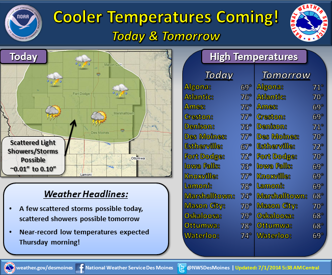
Cooler air will continue to move into the region tomorrow, as highs will be confined to the upper 60s and low 70s. For Thursday morning, the record low in Atlantic is 43 degrees. As of now, it appear the temperature Wednesday night into early Thursday morning we will be very close to that number.
Warmer air and storm chances will return to Iowa for this July 4th weekend, so if you do have outdoor plans Saturday into Monday, make sure to monitor the weather forecast each day, beginning with today.
Monday’s High in Atlantic was 78. Our low this morning: 62. Rainfall yesterday amounted to .26” Massena spotter Ardell McCunn reported .13″ rain there yesterday.
Here’s the Freese-Notis forecast:
Today: P/Cldy to Cldy & breezy, w/a 20% chance of showers this afternoon. High 76. W-NW @ 15-30.
Tonight: Mostly cloudy, with a low around 54. NW @ 10-20.
Wednesday: P/Cldy to Cldy. High 68. N-NW @ 10-15.
Wed. Night: P/Cldy. Low 49.
Thursday: P/Sunny, with a high near 75. S @ 5.
Thu. Night: Partly cloudy, with a low around 56.
Independence Day: Partly sunny, with a high near 80.
Fri. Night: Mo. Cldy w/a 40% chance of showers and thunderstorms. Low around 65. Breezy.
The National Weather Service in Des Moines says Preliminary Storm Surveys will take place today. Two teams will fan out to assess the damage occurring from Monday’s severe storms, and report on their findings. Their assessments will help to determine the type of weather event that occurred (such as a Tornado or straight-line winds, hail and flooding), duration and path. One of the teams will deploy from near Stuart to the Warren County line. The other team will cover an area between Story and Tama Counties.
The results and conclusions of the survey will be completed and uploaded to the National Weather Service website late this afternoon or early evening.


