
1130 AM CDT SUN AUG 31 2014
REST OF TODAY...PARTLY SUNNY. ISOLATED THUNDERSTORMS EARLY IN THE AFTERNOON…THEN SCATTERED THUNDERSTORMS LATE IN THE AFTERNOON. BREEZY. HIGH IN THE UPPER 80S. SOUTH WIND 15 TO 20 MPH. CHANCE OF THUNDERSTORMS 40 PERCENT.
TONIGHT…SHOWERS THROUGH MIDNIGHT. THUNDERSTORMS THROUGH THE NIGHT. SOME THUNDERSTORMS MAY PRODUCE DAMAGING WIND…LARGE HAIL AND HEAVY RAINFALL IN THE EVENING…THEN SOME THUNDERSTORMS MAY BE SEVERE WITH DAMAGING WIND…LARGE HAIL AND HEAVY RAINFALL. SOME THUNDERSTORMS MAY PRODUCE DAMAGING WIND…LARGE HAIL AND HEAVY RAINFALL AFTER MIDNIGHT. LOW IN THE MID 60S. SOUTH WIND 10 TO 15 MPH WITH GUSTS TO AROUND 25 MPH. CHANCE OF PRECIPITATION 90 PERCENT.
LABOR DAY…PARTLY SUNNY WITH A 20 PERCENT CHANCE OF THUNDERSTORMS UNTIL LATE AFTERNOON…THEN MOSTLY SUNNY LATE IN THE AFTERNOON. HIGH IN THE UPPER 70S. WEST WIND 5 TO 10 MPH.
MONDAY NIGHT…MOSTLY CLOUDY THROUGH MIDNIGHT…THEN PARTLY CLOUDY WITH A 20 PERCENT CHANCE OF THUNDERSTORMS AFTER MIDNIGHT. LOW IN THE UPPER 50S. NORTHWEST WIND NEAR 5 MPH.
TUESDAY…SUNNY. HIGH IN THE LOWER 80S. WEST WIND NEAR 10 MPH.
TUESDAY NIGHT AND WEDNESDAY…PARTLY CLOUDY. A 20 PERCENT CHANCE OF THUNDERSTORMS. LOW IN THE LOWER 60S. HIGH IN THE LOWER 80S.
IA COUNTIES: MONONA-HARRISON-SHELBY-POTTAWATTAMIE-MILLS-MONTGOMERY-FREMONT-PAGE…..NE COUNTIES-KNOX-CEDAR-THURSTON-ANTELOPE-PIERCE-WAYNE-BOONE-MADISON-STANTON-CUMING-BURT-PLATTE-COLFAX-DODGE-WASHINGTON-BUTLER-SAUNDERS-DOUGLAS-SARPY-SEWARD-LANCASTER-CASS-OTOE-SALINE- JEFFERSON-GAGE-JOHNSON-NEMAHA-PAWNEE-RICHARDSON-
1137 AM CDT SUN AUG 31 2014
THIS AFTERNOON AND TONIGHT… ISOLATED THUNDERSTORMS WILL AFFECT PARTS OF THE AREA THROUGH EARLY AFTERNOON. THESE STORMS SHOULD REMAIN MOSTLY BELOW SEVERE LIMITS. THUNDERSTORM COVERAGE AND STRENGTH SHOULD INCREASE ACROSS THE AREA LATER THIS AFTERNOON INTO THIS EVENING. CURRENT INDICATIONS SUGGEST SEVERE STORMS COULD DEVELOP BETWEEN 4 AND 6 PM IN EASTERN NEBRASKA WITH THE HIGHEST PROBABILITIES FOR THE STRONGEST STORMS INITIALLY DEVELOPING FROM OMAHA AND TEKAMAH SOUTHWEST THROUGH LINCOLN…DAVID CITY AND COLUMBUS. HOWEVER…SEVERE STORMS REMAIN A THREAT OVER THE ENTIRE REGION. THE THUNDERSTORMS SHOULD THEN DEVELOP OR SPREAD ACROSS THE REST OF THE AREA DURING THE EVENING.
LARGE HAIL…DAMAGING WINDS AND LOCALLY HEAVY RAIN ARE ALL POSSIBLE WITH THE STRONGER STORMS AND SOME OF THE HAIL COULD BE VERY LARGE. ISOLATED TORNADOES CAN NOT BE RULED OUT WITH MORE DISCRETE STORMS THAT MANAGE TO DEVELOP…ALTHOUGH THE ACTIVITY SHOULD BEGIN TO CONSOLIDATE THROUGH EVENING WITH DAMAGING WIND THE PRIMARY THREAT.
MINOR FLOODING SHOULD CONTINUE ALONG SOME SMALL STREAMS IN SOUTHEAST NEBRASKA. THAT FLOODING MAY BE AGGRAVATED OR NEW FLOODING COULD DEVELOP TONIGHT DUE TO LOCALLY HEAVY RAIN THAT MAY FALL. THE THUNDERSTORMS WILL BE THE RESULT OF A LARGE DISTURBANCE TRACKING ACROSS THE PLAINS TODAY WHICH WILL PUSH A COLD FRONT ACROSS EASTERN NEBRASKA BY EVENING AND INTO WESTERN IOWA TONIGHT.
LABOR DAY THROUGH SATURDAY…
THERE IS A CHANCE FOR THUNDERSTORMS MONDAY AND INTO MONDAY NIGHT FOR PARTS OF THE AREA. THE CHANCE OF SEVERE STORMS IN THOSE PERIODS SEEMS LOW AT THIS TIME. THUNDERSTORMS WILL ALSO BE POSSIBLE FOR PARTS OF THE AREA TUESDAY NIGHT…WEDNESDAY NIGHT AND THEN FROM THURSDAY NIGHT INTO SATURDAY AS SEVERAL DISTURBANCES CROSS THE REGION.
SPOTTER INFORMATION STATEMENT…STORM SPOTTERS COULD BE NEEDED LATER THIS AFTERNOON AND THIS EVENING.
AREA COUNTIES: SAC-CRAWFORD-CARROLL-AUDUBON-GUTHRIE-DALLAS-CASS-ADAIR-MADISON-ADAMS-UNION-TAYLOR-RINGGOLD…430 AM CDT SUN AUG 31 2014
TODAY AND TONIGHT – THUNDERSTORMS WILL DEVELOP THIS AFTERNOON AND CONTINUE TONIGHT. SEVERE WEATHER IS POSSIBLE WEST OF U.S. HIGHWAY 169 BY LATE THIS AFTERNOON AND OVER THE AREA ENTIRE AREA THIS EVENING. STRONG WINDS AND HAIL UP TO GOLF BALL SIZE ARE POSSIBLE. AN ISOLATED TORNADO IS POSSIBLE INTO THE VERY EARLY EVENING HOURS. HEAVY RAINFALL IS POSSIBLE WITH SOME STORMS PRODUCING RAINFALL TOTALS AROUND 3 INCHES.
AREA COUNTIES: MONONA-HARRISON-SHELBY-POTTAWATTAMIE-MILLS-MONTGOMERY-FREMONT-PAGE…
TODAY AND TONIGHT – ISOLATED TO SCATTERED SHOWERS AND THUNDERSTORMS SHOULD AFFECT PARTS OF THE AREA THROUGH EARLY AFTERNOON. THESE WILL PROBABLY REMAIN MOSTLY BELOW SEVERE LIMITS.
MORE THUNDERSTORMS ARE FORECAST FOR LATER THIS AFTERNOON AND THIS EVENING. CURRENT INDICATIONS SUGGEST SEVERE STORMS COULD DEVELOP BETWEEN 3 AND 5 PM IN EASTERN NEBRASKA. THE HIGHEST PROBABILITIES IN THAT TIME ARE ACROSS NORTHEAST NEBRASKA. STORMS SHOULD THEN DEVELOP OR SPREAD ACROSS THE REST OF THE AREA DURING THE LATE AFTERNOON AND EVENING.
LARGE HAIL…DAMAGING WINDS AND LOCALLY HEAVY RAIN SHOULD BE THE PRIMARY HAZARDS BUT ISOLATED TORNADOES CAN NOT BE RULED OUT.
Today – Scattered showers and thunderstorms, mainly after 1pm. Patchy fog before 8am. Otherwise, mostly sunny, with a high near 86. Breezy, with a south wind 7 to 16 mph, with gusts as high as 23 mph. Chance of precipitation is 30%. New rainfall amounts between a tenth and quarter of an inch, except higher amounts possible in thunderstorms.
Tonight – Showers and thunderstorms, mainly before 4am. Some storms could be severe, with large hail, damaging winds, and heavy rain. Low around 66. South southeast wind 10 to 13 mph. Chance of precipitation is 80%. New rainfall amounts between 1 and 2 inches possible.
Labor Day – A 20 percent chance of showers and thunderstorms before 1pm. Partly sunny, with a high near 78. West southwest wind around 9 mph becoming northwest in the afternoon.
Monday Night – A 20 percent chance of showers and thunderstorms after 1am. Partly cloudy, with a low around 58. North northwest wind around 6 mph becoming calm after midnight.
Tuesday – Mostly sunny, with a high near 82. West wind 3 to 8 mph.
Wednesday – Mostly sunny, with a high near 85.
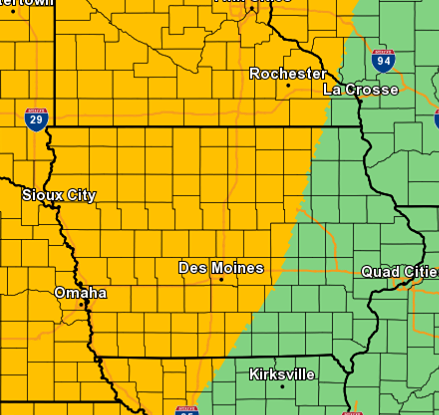
(click on image to enlarge) Area in yellow indicates a “Slight” risk of severe weather.
The National Weather Service in Des Moines reports thunderstorms are expected to develop during peak heating of the day Sunday along a cold front through the Missouri River Valley and then move into Iowa during the late afternoon and early evening hours. Some of the storms may be severe with heavy, potentially flooding rains. Large hail, damaging winds and a few tornadoes are all possible.
Many people will likely have outdoor plans this Labor Day weekend. Keep a close eye on the weather, have your safety plan in place and be ready to seek shelter if threatening weather approaches.
200 PM CDT SAT AUG 30 2014
REST OF TODAY…MOSTLY SUNNY. HIGH IN THE LOWER 80S. WEST WIND AROUND 5 MPH.
TONIGHT...MOSTLY CLEAR. LOW IN THE MID 60S. SOUTH WIND NEAR 5 MPH.
SUNDAY…MOSTLY SUNNY. A 50 PERCENT CHANCE OF THUNDERSTORMS LATE IN THE AFTERNOON. BREEZY. HIGH IN THE UPPER 80S. SOUTH WIND 5 TO 15 MPH INCREASING TO 15 TO 20 MPH IN THE AFTERNOON.
SUNDAY NIGHT…THUNDERSTORMS. LOW IN THE MID 60S. SOUTH WIND 5 TO 15 MPH. GUSTS UP TO 25 MPH THROUGH MIDNIGHT. CHANCE OF THUNDERSTORMS 80 PERCENT.
LABOR DAY...MOSTLY CLOUDY IN THE MORNING THEN BECOMING MOSTLY SUNNY. A 20 PERCENT CHANCE OF THUNDERSTORMS. HIGH AROUND 80. WEST WIND 5 TO 10 MPH.
MONDAY NIGHT…PARTLY CLOUDY. LOW IN THE UPPER 50S.
TUESDAY AND TUESDAY NIGHT…PARTLY CLOUDY. A 20 PERCENT CHANCE OF THUNDERSTORMS. HIGH AROUND 80. LOW AROUND 60.
WEDNESDAY…MOSTLY SUNNY. HIGH IN THE MID 80S.
The (podcast) KJAN listening area forecast & weather information for Atlantic.

Podcast: Play in new window | Download (1.0MB)
Subscribe: RSS
Today Areas of fog before 8am. Otherwise, mostly sunny, with a high near 83. West northwest wind 5 to 7 mph.
Tonight Mostly clear, with a low around 64. Light and variable wind becoming south southeast 5 to 7 mph after midnight.
Sunday A 50 percent chance of showers and thunderstorms after 4pm. Mostly sunny, with a high near 87. Breezy, with a south wind 8 to 17 mph, with gusts as high as 24 mph. New rainfall amounts of less than a tenth of an inch, except higher amounts possible in thunderstorms.
Sunday Night Showers and thunderstorms, mainly after 7pm. Low around 65. South southeast wind 8 to 15 mph, with gusts as high as 21 mph. Chance of precipitation is 80%. New rainfall amounts between three quarters and one inch possible.
Labor Day A 20 percent chance of showers and thunderstorms. Partly sunny, with a high near 80. West southwest wind 8 to 10 mph becoming northwest in the afternoon.
Monday Night Partly cloudy, with a low around 59.
Tuesday A 20 percent chance of showers and thunderstorms. Mostly sunny, with a high near 80
IA COUNTIES: MONONA-HARRISON-SHELBY-POTTAWATTAMIE-MILLS-MONTGOMERY-FREMONT-
PAGE…1130 AM CDT FRI AUG 29 2014
DAY ONE…THIS AFTERNOON AND TONIGHT
SCATTERED THUNDERSTORMS ARE EXPECTED THIS AFTERNOON INTO THIS EVENING MAINLY OVER EXTREME EASTERN NEBRASKA AND SOUTHWEST IOWA AS A WEAK COLD FRONT MOVES THROUGH THE AREA. SOME STORMS MAY PRODUCE LOCALLY HEAVY RAIN…ISOLATED STORMS COULD ALSO BRIEFLY PRODUCE SMALL HAIL.
MINOR FLOODING WILL CONTINUE WITH SOME SMALL STREAMS IN THE LOCAL AREA THIS AFTERNOON. FLOODING WILL ALSO OCCUR ALONG THE MISSOURI RIVER FROM AROUND BROWNVILLE DOWNSTREAM TO PAST RULO.
DAYS TWO THROUGH SEVEN…SATURDAY THROUGH THURSDAY
SCATTERED THUNDERSTORMS COULD AGAIN MOVE INTO NORTHEAST NEBRASKA BY LATE SATURDAY NIGHT. THUNDERSTORM CHANCES WILL INCREASE SUNDAY AND CONTINUE INTO SUNDAY NIGHT AS AN UPPER LEVEL DISTURBANCE AND FRONTAL SYSTEM MOVE THROUGH THE REGION.
SEVERE THUNDERSTORMS WILL BE POSSIBLE SUNDAY…MAINLY IN THE AFTERNOON AND EVENING. DAMAGING WINDS…LARGE HAIL…AND LOCALLY HEAVY RAINFALL ARE EXPECTED TO BE THE PRIMARY HAZARDS. MINOR FLOODING ALONG THE MISSOURI RIVER IS EXPECTED TO CONTINUE AROUND AND DOWNSTREAM FROM BROWNVILLE.
SPOTTER INFORMATION STATEMENT…
SPOTTER ACTIVATION IS NOT EXPECTED TO BE NEEDED THIS AFTERNOON OR TONIGHT. HOWEVER…SPOTTERS ARE ENCOURAGED TO REPORT RAINFALL AMOUNTS OVER ONE INCH TO THE NATIONAL WEATHER SERVICE AT OMAHA. ALSO REPORT HAIL DIME SIZE OR LARGER AND STRONG WINDS IF THEY OCCUR.
A national report on climate change finds even with global warming, we’ll still have plenty of snow in the winters ahead in Iowa and across much of the country’s northern half. State Climatologist Harry Hillaker says climate change is very gradual and snow blowers and shovels will remain necessities. Hillaker says the report from M-I-T didn’t exactly go out on a limb in predicting continued snowy winters for Iowa.
“When you think about it, that’s not really much of a surprise, I guess the basic mechanism on how we get snow is not going to be changing in a warmer world,” Hillaker says. “The number of opportunities may be decreasing but the storms could be just as intense but probably not as frequent as what we’ve been seeing in years past.” The Old Farmers’ Almanac forecasts the winter ahead will be colder than usual, then next summer will be hotter. The publication predicts winter temperatures, precipitation and snowfall will all be below normal, with the coldest period running from early December into the first half of January. Hillaker says it’s an extreme challenge to accurately predict the weather several months in advance.
“Certainly, not very easily and there’s lots of outfits out there like the Farmer’s Almanac and some private forecasters that attempt to do that sort of thing,” Hillaker says. “I don’t know if anyone’s attempted any kind of study of how accurate those prognostications are, but certainly it’s very, very difficult and we’ve got a long ways to go in those longer-range outlooks.” While scientific advancements are making forecasts more on-target, Hillaker says no one can really predict now, at summer’s end, what the weather will be this winter.
“Certainly, the day-by-day forecasts, out a week or two, have gotten far, far better than they used to be just in the last 20 or 30 years, tremendous improvements,” Hillaker says. “On that longer range, say from 30 days on out, there’s some skill there, but still a lot of guess work.” The M-I-T study predicts some regions will see less snowfall, but the snowfall extremes may actually intensify. Hillaker notes, Iowa’s had above-average snowfall in seven of the past eight winters.
(Radio Iowa)


