
Today: Sunny, with a high near 81. South southwest wind 5 to 15 mph, with gusts as high as 20 mph. Elevated fire weather conditions.
Tonight: Mostly clear, with a low around 52. South wind 10-20 mph.
Monday: Sunny & breezy. High near 80. S@ 10-25 mph. Elevated fire weather conditions continue.
Mon. Night: Cloudy to Partly cloudy, w/a 40% chance of showers & thunderstorms late. Low around 53. New rainfall amounts of less than a tenth of an inch, except higher amounts possible in thunderstorms.
Tuesday: Sunny. High near 78. South wind 5 to 10 mph becoming westerly in the afternoon.
Wednesday: Mostly sunny, with a high near 65.
Thursday: Sunny, with a high near 65.
Saturday’s High in Atlantic was 78. The Low was 52. Last year on this date, the High in Atlantic was 77 and the Low was 36. The Record High for Oct. 20th in Atlantic was 87 in 1947 & 2003. The Record Low was 14 in 1960. Sunrise today: 7:38. Sunset: 6:32.
Today: Mostly sunny, with a high near 77. South/southwest winds 10 to 20 mph.
Tonight: Mostly clear, with a low around 52. S/SW winds 10-20.
Tomorrow: Sunny, with a high near 79. S/SW winds 5 to 15 mph, with gusts as high as 20 mph.
Tom. Night: Mostly clear, with a low around 50.
Monday: Mostly sunny w/a slight chance of afternoon showers. High near 77.
Monday Night: A 50% chance of showers, with thunderstorms also possible after midnight. Low around 51.
Tuesday: Sunny, with a high near 75.
Wednesday: Mostly sunny, with a High around 64.
Friday’s High in Atlantic was 75. The Low was 49. Last year on this date, the High in Atlantic was 69 and the Low was 37. The Record High for Oct. 19th in Atlantic was 88 in 2003. The Record Low was 12 in 1972 & 2022. Sunrise today: 7:36. Sunset: 6:33.
(updated) [Radio Iowa] – The latest U-S Drought monitor map is showing more color, which is not what the state needs to see, as that indicates more drought. D-N-R hydrologist Tim Hall says there’s just a small patch of clear area on the map near the Missouri border. “Ninety-eight percent of the state is now at least in abnormal dry, if not drought, conditions. And actually the big change this week is we just about doubled the amount of the states that validated in severe drought in northeastern and northwestern and western Iowa,” Hall says. Hall says the concern level is not very high at this point.
“So the fact that we had eight out of 12 months with above normal rain, going back to a year ago, certainly helps us to not be in a really scary spot we’ve had so far in the month of October, we’ve had seven percent of normal rainfall,” he says. That comes after a September that was the driest in the history of state weather records. “If you put September and October together, we’re coming up on four inches short of rain just in those two months, which are generally pretty dry months to begin with,” Hall says. “So a really, really dry, sudden turn, but it’s not as significantly worrisome as it would have been, had we not had month over month over month rather going back to October of last year.” Hall says precipitation normally drops off each month as we head through fall and into winter, and it usually isn’t a big worry. 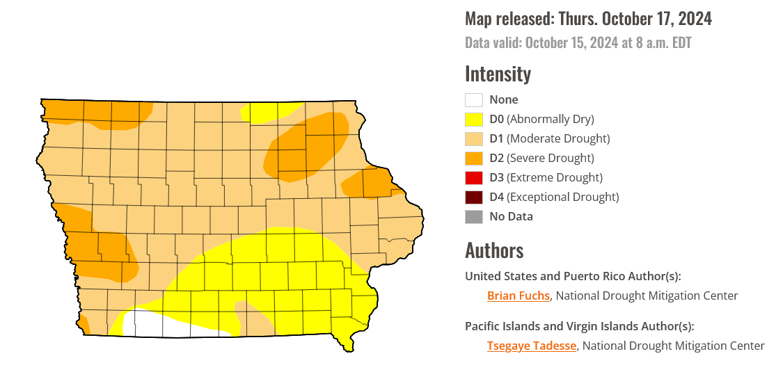
“The water demand is not significant this time of the year, so whatever rain we do get will tend to benefit us. We’re not in the middle of a growing season, and as the temperatures cool, we tend to see less evaporative demand on water,” he says. Hall says the concern will increase if we continue to see dry months into spring.
Today: Sunny & windy. High near 74. South winds 15 to 35 mph. ELEVATED FIRE DANGER due to low humidity, dry surface vegetation and cropland, and strong/gusty winds.
Tonight: Partly cloudy, with a low around 46. South winds 10-20 mph.
Tomorrow: Mostly sunny, with a high near 74. S/SW winds 10-20 mph.
Tom. Night: Mostly clear, with a low around 48. South southwest wind around 5-10 mph.
Sunday: Sunny, with a high near 77.
Sunday Night: Partly cloudy, with a low around 49.
Monday: Partly sunny w/a 30% chance of afternoon showers. High near 74.
Monday Night: A 40% chance of showers. Low around 50.
Tuesday: Sunny, with a high near 74.
Thursday’s High in Atlantic was 70. The Low was 43. Last year on this date, the High in Atlantic was 68 and the Low was 49. The Record High for Oct. 18th in Atlantic was 86 in 2003. The Record Low was 13 in 2022. Sunrise today: 7:35. Sunset: 6:35.
316 AM CDT Fri Oct 18 2024
…Elevated Fire Danger Today…
WHAT…Stronger winds from the south at 15 to 20 mph with gusts around 25 to 35 mph, dry surface vegetation and cropland, and low relative humidity between 25 and 30 percent will lead to elevated fire danger today.
WHERE…Across all of central Iowa. 
WHEN… From 11am to 7pm today.
IMPACTS…Any fires that ignite will spread rapidly and become very difficult to control, especially in cropland.
PREPAREDNESS AND PRECAUTIONARY ACTIONS…Burning is strongly discouraged under these conditions. Also, take extra care to prevent the start of accidental fires when smoking or operating vehicles around dry vegetation or crops.
Today: **RED FLAG WARNING 11-a.m. to 7-p.m. for critical fire weather conditions** Sunny & windy. High near 71. South winds 15 to 25 mph, with gusts as high as 40 mph.
Tonight: Clear & windy. Low around 45. S @ 15-30 mph.
Tomorrow: Sunny & windy. High near 74. S @ 15-35 mph.
Tom. Night: Partly cloudy & breezy. Low around 46. S @ 10-25 mph.
Saturday: Mostly sunny, with a high near 74.
Sunday: Sunny, with a high near 75.
Monday: Partly sunny w/a 50% chance of showers. High near 69.
Wednesday’s High in Atlantic was 61. Our Low this morning was 20. That 24-hour temperature tied the record low previously set in 1976 & 1977. Last year on this date, the High in Atlantic was 70 and the Low was 31. The Record High for Oct. 17th in Atlantic was 87, in 1947 & 2016. The Record Low was 12 in 1976. Sunrise today: 7:33. Sunset: 6:36.
Today: FREEZE WARNING until 9-a.m. – Widespread frost this morning; Elevated Fire Danger! Sunny & breezy. High near 60. S/SW winds 10-25 mph.
Tonight: Clear, with a low around 35. South winds 10-20.
Tomorrow: Sunny & windy. High near 71. FIRE WEATHER WATCH from 11-a.m. until 7-p.m. Winds South at 20-40 mph.
Tom. Night: Mostly clear & windy. Low around 45. S @ 20-35 mph.
Friday: Sunny & windy. High near 73.
Fri. night: Partly cloudy & breezy. Low around 47.
Saturday: Mostly sunny, with a high near 72.
Sunday: Sunny, with a high near 74.
Tuesday’s High in Atlantic was 58. The Low this morning (& 24-hour low [7-a.m. to 7-a.m.]), was 20. As of 7:05-a.m., Atlantic tied the 24-hour Record Low for Oct. 16th. That temperature was previously set in 1976 & 1977. Last year on this date, the High in Atlantic was 65 and the Low was 31. The Record High for Oct. 16th in Atlantic was 87, in 1921. Sunrise today: 7:33. Sunset: 6:38.
The northern part of the state saw freezing temperatures overnight, and the rest of the state is expected to get them tonight.
National Weather Service meteorologist Dylan Dodson says central and southern Iowa are under a freeze warning, and the north will be cold again. “Since we already reached those freezing temperatures in the north last night, the growing season has ended up there. So there’s not a freeze warning for that we issue it for for plant and sensitive stuff like that,” he says. “Since we’ve already reached that hard freeze, there’s not a freeze warning up there, but they will still be reaching temperatures as low as the mid 20s.”
Dodson says this is about that time of year when we start seeing these freezing temperatures, and he says the freezing cold is making a short visit for now. “You know, tonight and tomorrow morning will get pretty cold, and then you’ll see temperatures steadily warming through the week. Tomorrow night’s lows are in the mid to upper 30s, maybe even 40,” Dodson says. “And temperatures during the day, we’ll see highs in the 60s tomorrow, and then 60s, so maybe even the 70s on Thursday, and then by Friday and Saturday, we’ll be back well into the 70s.” 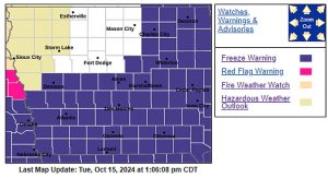
He says we shouldn’t have to worry about the cold again for a while. “Our forecast Friday through the rest of the end of the forecast is in those 70s. And I know that the Climate Prediction Center, their graphics have us for the six to 10-day outlook and then the eight to 14-day outlook are both above normal temperatures,” Dodson says.
While the cold is a concern for most of the state, the far northwest corner of the state remains in a Fire Weather Watch as conditions are right so any fires that develop would likely spread rapidly.
Today: FROST ADVISORY in effect until 8-a.m.; Mostly cloudy through mid morning, then gradual clearing, with a high near 55. NE wind 10-20 mph.
Tonight: Widespread frost after 11pm. FREEZE WARNING from 1-a.m. until 9-a.m. Wednesday; Clear, with a low around 26.
Tomorrow: Widespread frost, mainly before 9am; Sunny, with a high near 62. S winds 10-20 mph.
Tom. Night: Clear, with a low around 39. S winds 10-25 mph.
Thursday: Sunny & windy, with a high near 69.
Friday: Sunny & windy, with a high near 73.
Monday’s High in Atlantic was 60. The Low 30. We received a few sprinkles in Atlantic early this morning. Last year on this date, the High in Atlantic was 53 and the Low was 37. The Record High for Oct. 15th in Atlantic was 89, in 1892. The Record Low was 17 in 1952. Sunrise today: 7:31. Sunset: 6:39.
Today (Columbus Day): Widespread frost, mainly before 9am. Sunny, with a high near 58. Calm wind becoming north northwest 5 to 10 mph this afternoon. Freeze Advisory until 9-a.m.
Tonight: Increasing clouds, with a low around 28. NE winds 10-20 mph. Frost Advisory until 9-a.m. Tuesday.
Tomorrow: Sunny, with a high near 54. NE 10-20 mph.
Tom. Night: Widespread frost. Mostly clear, with a low around 25.
Wednesday: Widespread frost, mainly before 9am. Otherwise, sunny, with a high near 60. Freeze Watch in effect until 9-a.m.
Wednesday Night: Mostly clear, with a low around 38.
Thursday: Sunny, with a high near 69. Windy.
Sunday’s High in Atlantic was 61. Our Low this morning was 31. Last year on this date, the High in Atlantic was 50 and the Low was 45. The Record High was 88 in 1897. The Record Low was 16 in 1937. Sunrise today: 7:30. Sunset: 6:41.


