
State Climatologist Justin Glisan says the month that just ended will be one of the warmer Septembers in the state weather book. “So we’re about 67 degrees as the average temperature for the state, and that’s almost four degrees above average,” Glisan says. “So looking at the preliminary record going back 151 years, looks like we’ll be in the top 20 warmest September’s on record.” Glisan says the final week of September really impacted the final number. “The last seven days we averaged almost 10 degrees above average,” he says. Glisan says September’s precipitation total didn’t do a lot to help pull the state out of the drought.
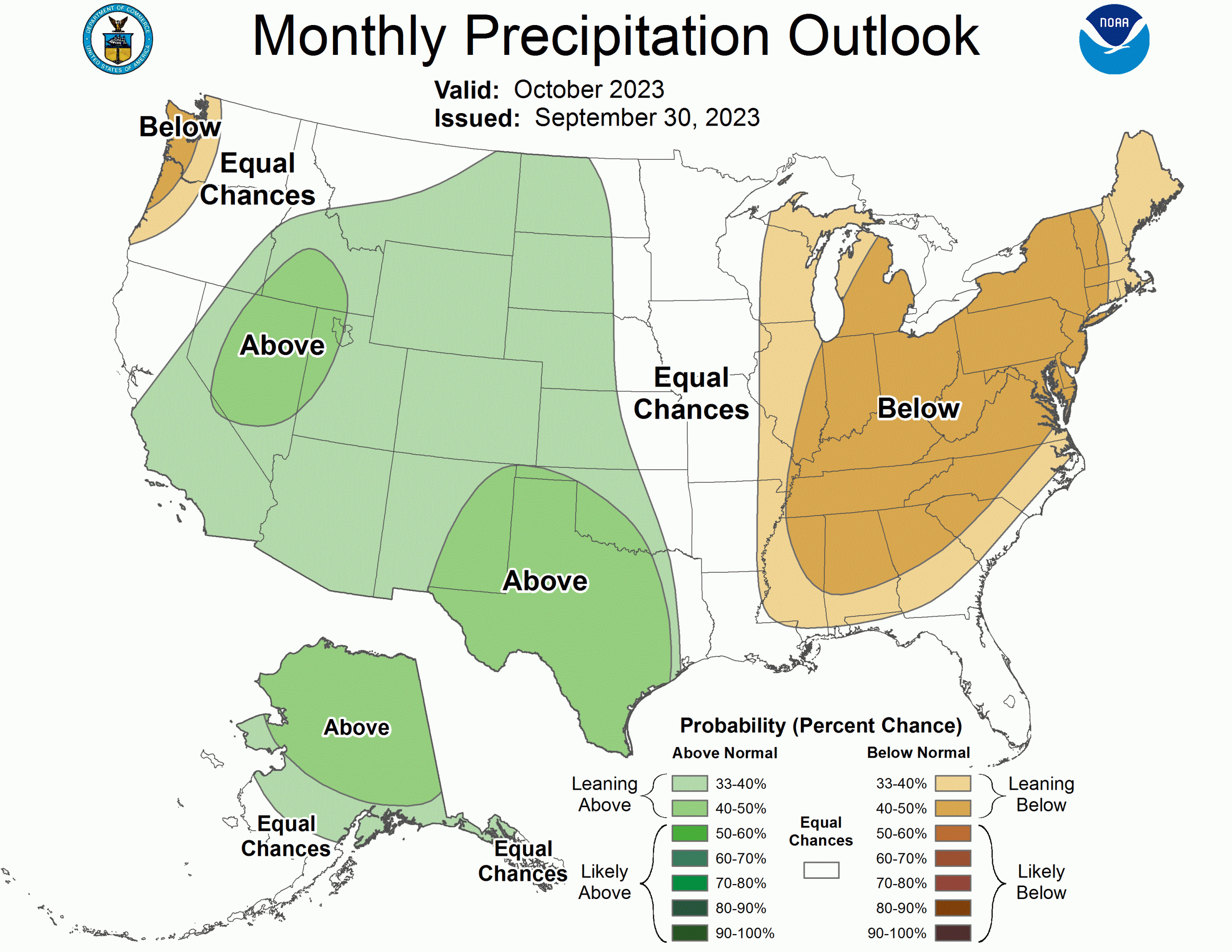
“We’re about one-point-four-two (1.42) inches below average on the precipitation side. Typically we’re about three and a half inches and we were about two inches over the last 30 days,” he says. Glisan says the short-term forecasts are signaling continued dry weather. “And then with that warmer temperature signal, a dry signal as well for the first half of the month. Looking at the overall climate prediction center outlooks, we see above average chances for warmer conditions for the entire month — but equal chances — we’re right in between wetter chances to our west and very dry conditions possible in the eastern part of the Corn Belt, right in the middle. So equal chances of above below or near average,” Glisan says.
He says that outlook is for the next seven to ten days.
Today: Partly sunny & windy, w/a slight chance of showers & thunderstorms late this afternoon. High 82. S @ 10-20 w/gusts to near 30 mph.
Tonight: Cloudy w/showers & thunderstorms after midnight. Low around 59. S/SW @ 10-20 w/gusts to near 30.New rainfall amounts between a tenth and quarter of an inch, except higher amounts possible in thunderstorms.
Tomorrow: Mostly sunny, with a high near 72. W/NW winds 10 mph.
Thursday: Sunny, with a high near 71.
Friday: Mo. Sunny & windy w/a slight chance of showers. High near 55.
Monday’s High in Atlantic was 88. The Low was 62. Last year on this date, the High in Atlantic was 79 and the Low was 43. The Record High for Oct. 3rd in Atlantic was 95 in 1997, and the Record Low was 23, in 2010. Sunrise is at 7:18. Sunset at 7:00.
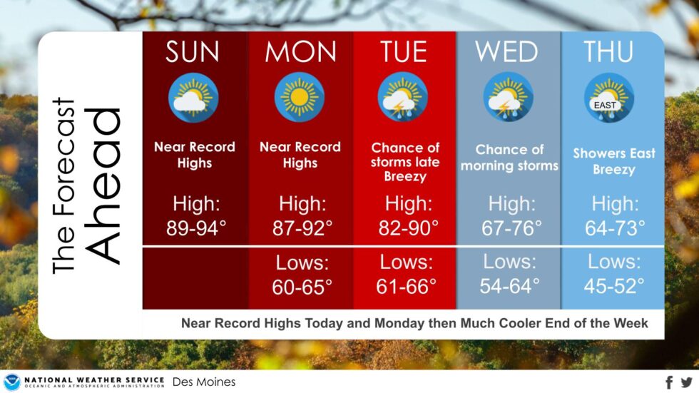
(Radio Iowa) – Forecasters say it may be one of “those” weeks in Iowa where we have to run the air conditioner one day and the furnace on the next to stay comfy. Meteorologist Marvin Percha, at the National Weather Service, says it’s been unseasonably hot and very un-October-like, with record highs that have stood for decades broken over the weekend. “Temperature records, many of them in the low 90s, were either tied or broken, 92 at Des Moines, 91 at Waterloo,” Percha says. “It’s been impressive, especially the number of days in a row since we’re at day three or four in all of this now.” Percha says he expects more near-records today (Monday) with the forecast calling for highs in the upper 80s and low 90s across much of Iowa.
“And then tomorrow will be slightly cooler with temperatures falling in the mid to upper 80s, but relief is on the way,” Percha says. “We’re going to have a front that’s going to be moving in Tuesday into Wednesday, certainly it will drop temperatures much closer to normal and give us at least a chance for some rainfall.” Within a few days, Iowans may be wishing for the warmer weather we now have as the chill of fall will settle in soon enough.
National Weather Service graphic
“We’re going to have a series of cold fronts moving in, in the latter part of the week and into the weekend,” Percha says. “As a matter of fact, we looking at our first chance for frost and freezing temperatures by the end of the week, especially into Saturday morning. Many areas, certainly looking at lows likely falling into the 30s and there’s a chance that they might be approaching freezing levels as well.” Keep up with the changing forecast at weather-dot-gov.
Today: Sunny, with a high near 90. South wind 10-20 mph.
Tonight: Mostly clear, with a low around 65. South wind 10-20 mph.
Tomorrow: Partly sunny & windy w/a chance of afternoon showers. High near 85. S @ 15-30 mph.
Tom. Night: Showers & thunderstorms. Low around 59. S @ 15-30 mph. New rainfall amounts between a tenth and quarter of an inch, except higher amounts possible in thunderstorms.
Wednesday: Mostly sunny, with a high near 73.
Thursday: Sunny, with a high near 71. Breezy.
Sunday’s High in Atlantic was 91. Our Low this morning, 67. Last year on this date, the High in Atlantic was 78 and the Low was 44. The Record High for Oct. 2nd in Atlantic was 93 in 1892, and the Record Low was 18, in 1974. Sunrise is at 7:17. Sunset at 7:02.
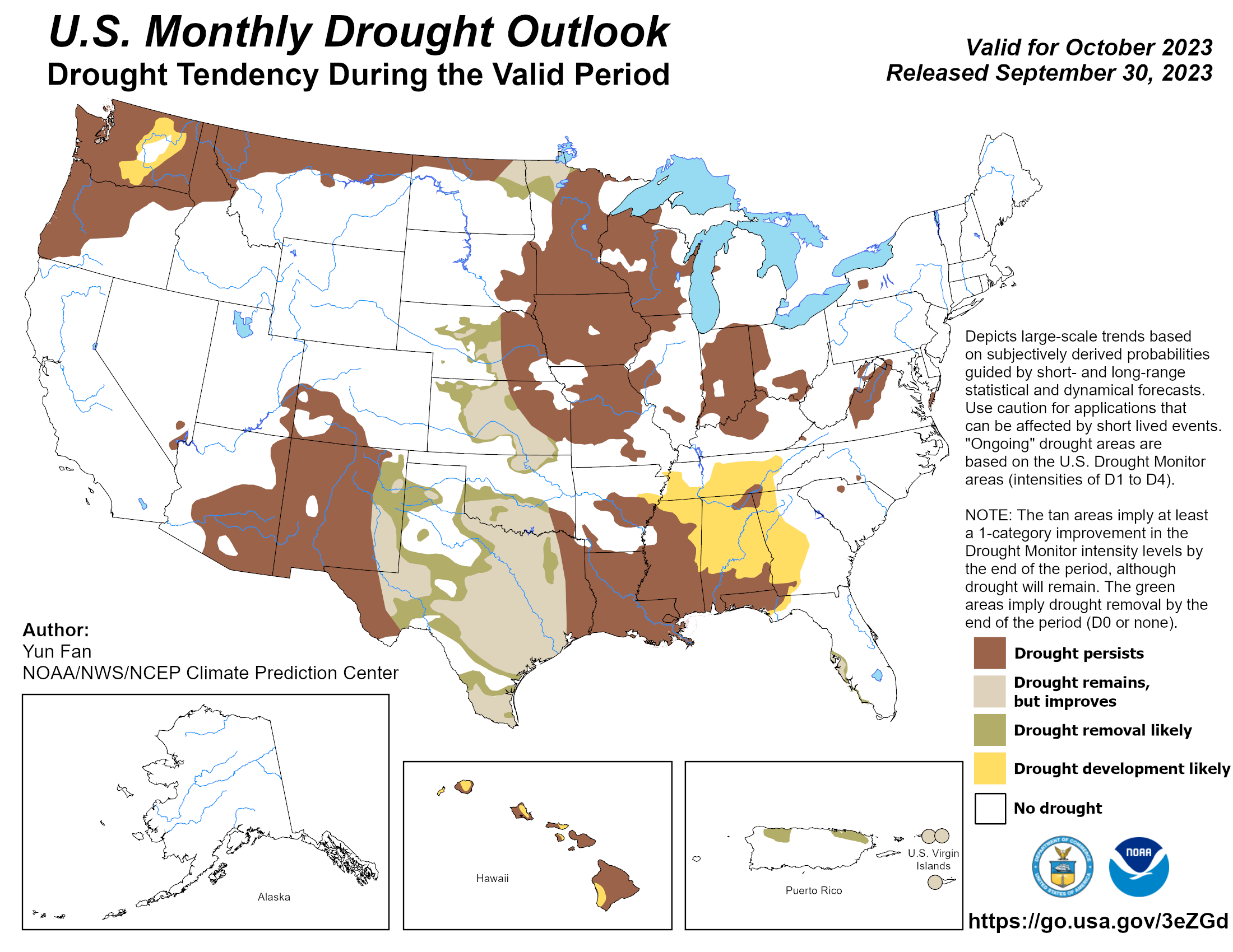
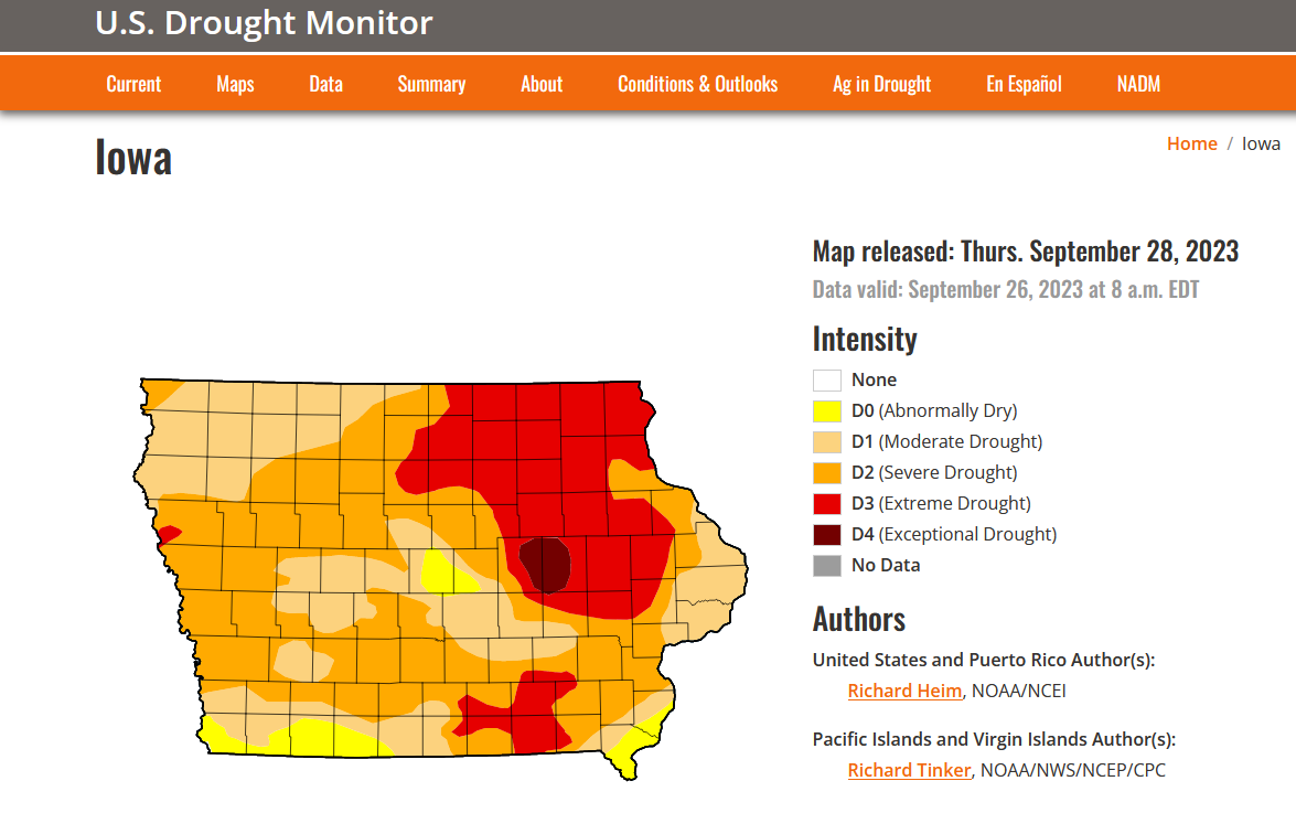
(College Park, MD) – NOAA’s Climate Prediction Center released its latest monthly drought outlook for October 2023, showing where drought is expected to improve, worsen, or remain the same over the next month: Atlantic, Iowa is currently in Moderate Drought (D1), according to the U.S. Drought Monitor, and conditions are expected to persist over the next month.
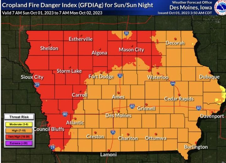
(Southwest Iowa) – In response to a rash of recent field and ditch fires having taken place, another southwest Iowa County has been placed under a Burn Ban. No open burning is allowed in Audubon County by Order of the State Fire Marshall, per a request from Audubon County Emergency Management Director Tyler Thygesen, acting on behalf of the fire department chiefs in Audubon County.
The Audubon County Burn Ban is in effect now (Oct. 1st) until further notice (when conditions are such that a danger to life and/or property does not exist from opening burning, and at the discretion of the Fire Marshal). Any violation of the proclamation is a simple misdemeanor, punishable by a $200 fine. 
A burn ban does not prohibit the following: supervised, controlled burn for which a permit has been issued by the fire chief of the fire district where the burn will take place, the use of outdoor fireplaces, barbecue grills, properly supervised landfills, or the burning of trash in incinerators or trash burners made of metal, concrete, masonry, or heavy one-inch wire mesh, with no openings greater than one square inch.
Previously, officials in Shelby County announced a Burn Ban was in effect beginning Oct. 1st, and until further notice. Harrison and Crawford Counties have also instituted a ban on opening burning over the past 10-days.
Weather data for the month of Sept. 2023 in Atlantic show the Average High for the month was 83 and the Average Low was 52. Rainfall for the month amounted to 2.64. The normal average high in Atlantic during the month of September is 76 and the Low is 51, so Sept. 2023 was about 7 degrees warmer than the norm, and the Low was almost on track for the month. Precipitation for September typically amounts to 3.81, so our deficit was 1.17-inches.
Looking ahead, we find the Average High for the month of October is 64, the Low is 39, and precipitation (rain & or melted snow) is around 2.76 inches.
Hazardous Weather Outlook
National Weather Service Omaha/Valley NE
441 AM CDT Sun Oct 1 2023
Monona-Harrison-Shelby-Pottawattamie-Mills-Montgomery-Fremont-
Page Counties…
Today and Tonight: High to very high fire danger is expected this afternoon and early evening. High to very high fire danger will be possible again on Monday afternoon and evening. Please refrain from any open burning.
Today: Sunny, with a high near 91. South wind 9 to 14 mph, with gusts as high as 20 mph.
Tonight: Mostly clear, with a low around 63. South southeast wind 8 to 10 mph.
Monday: Sunny, with a high near 89. South wind 8 to 14 mph, with gusts as high as 18 mph.
Monday Night: Partly cloudy, with a low around 65. South wind 9 to 14 mph, with gusts as high as 21 mph.
Tuesday: A 30 percent chance of showers after 1pm. Mostly cloudy, with a high near 86. Breezy, with a south wind 13 to 20 mph, with gusts as high as 29 mph. New precipitation amounts of less than a tenth of an inch possible.
Tuesday Night: Showers and possibly a thunderstorm. Low around 57. Windy. Chance of precipitation is 80%. New rainfall amounts between a quarter and half of an inch possible.
Wednesday: A slight chance of showers and thunderstorms. Partly sunny, with a high near 72. Breezy. Chance of precipitation is 20%.
Saturday’s High of 92 in Atlantic tied the Record High for Sept. 30th, set in 1994. Our Low this morning, was 68. Last year on this date, the High in Atlantic was 77 and the Low was 41. The Record High for Oct. 1st in Atlantic was 96 in 1892, and the Record Low was 23, in 1984. Sunrise is at 7:16. Sunset at 7:02.
Today: Sunny & breezy, with a high near 92. Winds out of the south at 15-25 mph.
Tonight: Mostly clear, with a low around 67. South southeast wind 15-25 mph.
Sunday: Sunny, with a high near 89. South wind 10-20 mph.
Sunday Night: Partly cloudy, with a low around 61. South southeast wind around 10 mph.
Monday: Sunny, with a high near 87.
Monday Night: Partly cloudy & breezy, with a low around 64.
Tuesday: Cloudy & windy w/a 30% chance of showers during the afternoon. High near 82.
Friday’s High in Atlantic was 92. The Low was 65. Last year on this date, the High in Atlantic was 75 and the Low was 40. The Record High for Sept. 30th in Atlantic was 92 in 1994, and the Record Low was 21, in 1894. Sunrise is at 7:15. Sunset at 7:04.


