
AREA COUNTIES: DALLAS-ADAIR-MADISON-ADAMS-UNION-TAYLOR-RINGGOLD
WINTER STORM WATCH IN EFFECT FROM SATURDAY EVENING THROUGH SUNDAY AFTERNOON.
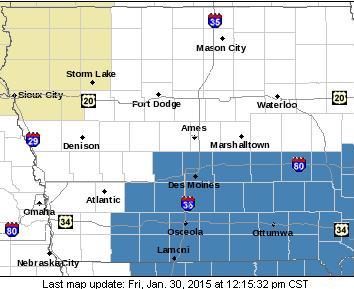
Winter Storm Watch covers the counties in blue.
THE NATIONAL WEATHER SERVICE IN DES MOINES HAS ISSUED A WINTER STORM WATCH…WHICH IS IN EFFECT FROM SATURDAY EVENING THROUGH SUNDAY AFTERNOON.
* TIMING…SNOW WILL PICK UP IN INTENSITY SATURDAY EVENING AND CONTINUE AT LIGHT TO MODERATE RATES INTO SUNDAY.
* STORM TOTAL SNOW…ACCUMULATIONS OF 5 TO 9 INCHES ARE EXPECTED WITH LOCALLY HIGHER AMOUNTS. HIGHEST AMOUNTS APPEAR TO BE MOST LIKELY IN THE EASTERN SIDE OF THE WATCH AREA.
* WINDS/VISIBILITY…NORTH WINDS WILL INCREASE SATURDAY NIGHT AND PERSIST INTO SUNDAY AT 15 TO 20 MPH WITH GUSTS TO 30 MPH.
* IMPACTS…ROADS WILL BECOME SLICK AND HAZARDOUS. DRIFTING SNOW WILL CREATE LOW VISIBILITIES SUNDAY AND MAY MAKE IT DIFFICULT FOR ROAD CREWS TO KEEP ROADS CLEAR…ESPECIALLY IN OPEN AREAS.
PRECAUTIONARY/PREPAREDNESS ACTIONS… A WINTER STORM WATCH MEANS THERE IS A POTENTIAL FOR SIGNIFICANT SNOW…SLEET…OR ICE ACCUMULATIONS THAT MAY IMPACT TRAVEL. CONTINUE TO MONITOR THE LATEST FORECASTS.
LINCOLN, Neb. (AP) – Parts of Iowa, Missouri and other Midwest states are teetering close to drought status. The National Drought Mitigation Center on Thursday classified a large swath of southern Iowa, areas along the northern Missouri border and the region east toward Illinois and Wisconsin as abnormally dry. This is one level below its moderate drought category. The label comes just a week after the center categorized the area as normal.
The Omaha World-Herald reports much of the Plains, including Minnesota, the Dakotas and southern Nebraska, were already near drought or in drought, and most of the region remains unchanged from last week. Much of the country has experienced a warmer and drier winter than normal. The drought center is located at the University of Nebraska-Lincoln.
The Freese-Notis weather forecast for Atlantic & the KJAN listening area, and weather data for Atlantic.

Podcast: Play in new window | Download (1.2MB)
Subscribe: RSS
Today: Sunny, with a high near 37. Light and variable wind becoming south southwest 8 to 13 mph in the morning.
Tonight: Partly cloudy, with a steady temperature around 33. South wind 7 to 10 mph.
Saturday: A chance of snow before noon, then rain likely between noon and 3pm, then rain and snow likely after 3pm. Cloudy, with a high near 38. Southwest wind 5 to 10 mph becoming southeast in the afternoon. Chance of precipitation is 70%. New snow accumulation of less than a half inch possible.
Saturday Night: Snow. Low around 23. East southeast wind 6 to 13 mph becoming north northeast after midnight. Winds could gust as high as 21 mph. Chance of precipitation is 80%. New snow accumulation of 1 to 3 inches possible.
Sunday: Snow likely, mainly before noon. Cloudy, with a high near 23. Windy, with a north wind 15 to 23 mph, with gusts as high as 32 mph. Chance of precipitation is 70%. New snow accumulation of around an inch possible.
Sunday Night: Mostly cloudy, with a low around 3. Blustery.
Monday: A 20 percent chance of snow. Partly sunny, with a high near 23
401 AM CST THU JAN 29 2015
…WIND ADVISORY IN EFFECT UNTIL 9 AM CST THIS MORNING…
EARLY THIS MORNING…CLOUDY…BREEZY. NORTHWEST WIND 20 TO 25 MPH WITH GUSTS TO AROUND 35 MPH.
TODAY…CLOUDY IN THE MORNING THEN BECOMING PARTLY SUNNY. BREEZY… COLDER. HIGH IN THE UPPER 30S. NORTHWEST WIND 15 TO 25 MPH WITH GUSTS TO AROUND 35 MPH.
TONIGHT…PARTLY CLOUDY. COLDER. LOW AROUND 20. NORTH WIND NEAR 15 MPH. GUSTS UP TO 25 MPH THROUGH MIDNIGHT.
FRIDAY...SUNNY. HIGH AROUND 40. SOUTHEAST WIND NEAR 5 MPH SHIFTING TO THE SOUTH IN THE AFTERNOON.
SATURDAY…CLOUDY. A SLIGHT CHANCE OF LIGHT SNOW IN THE MORNING… THEN A CHANCE OF LIGHT RAIN AND LIGHT SNOW IN THE AFTERNOON. HIGH AROUND 40. WEST WIND 5 TO 10 MPH SHIFTING TO THE NORTHWEST IN THE AFTERNOON. CHANCE OF PRECIPITATION 40 PERCENT.
SATURDAY NIGHT…CLOUDY WITH A 50 PERCENT CHANCE OF SNOW. COLDER. LOW 15 TO 20.
SUNDAY…CLOUDY. A 30 PERCENT CHANCE OF SNOW IN THE MORNING. BREEZY…COLDER. HIGH IN THE MID 20S.
SAC-CRAWFORD-CARROLL-AUDUBON-GUTHRIE-DALLAS-CASS-ADAIR-MADISON-ADAMS-UNION-TAYLOR-RINGGOLD COUNTIES….A WIND ADVISORY REMAINS IN EFFECT UNTIL 9 AM. HARRISON-SHELBY-POTTAWATTAMIE-MILLS-MONTGOMERY-FREMONT-PAGE-COUNTIES….A WIND ADVISORY REMAINS IN EFFECT UNTIL 7 AM.
* TIMING…STRONG WINDS WILL CONTINUE EARLY THIS MORNING.
* WINDS…EXPECT SUSTAINED NORTHWEST WINDS OF 25 TO 35 MPH WITH GUSTS TO 40 MPH THROUGH MID MORNING.
* IMPACTS…LOSE OBJECTS WILL BE BLOWN AROUND. DRIVING HIGH PROFILE VEHICLES WILL BE DIFFICULT.
PRECAUTIONARY/PREPAREDNESS ACTIONS...
A WIND ADVISORY MEANS THAT WINDS GREATER THAN 30 MPH ARE EXPECTED. WINDS THIS STRONG CAN MAKE DRIVING DIFFICULT…ESPECIALLY FOR HIGH PROFILE VEHICLES. USE EXTRA CAUTION.
DES MOINES, Iowa (AP) – The Iowa Transportation Department is testing a new system that could help motorists drive more safely on icy roadways. Des Moines television station KCCI says the testing is underway on an 11-mile stretch of Interstate 35 north of Des Moines. During and after storms, some drivers go too fast, some too slow.
The system being tested comes up with a limit that, if observed, would smooth out traffic flow and make travel safer. The system includes sensors that use lasers to detect the ice, snow or slush on the pavement. Engineer Willy Sorenson says the system uses the data to determine what he calls an “advised” lower speed limit. That safer speed limit is sent to four digital speed limit signs along the roadway.
It’s feeling more like March, rather than late January, across much of Iowa this week. National Weather Service meteorologist Craig Cogill says today (Wednesday) will be even warmer with many locations likely to break record highs for January 28. “Forecast highs around Des Moines are for the mid to upper 50s, so it certainly looks possible that we break a record — with the old record being 56-degrees back in 1931,” Cogill said. Some sections of western Iowa are expected to post temperatures in the 60’s. More winter-like weather will return to the state soon, as a cold front pushes in tomorrow night and snow could be falling this weekend.
“We’ll have cooler temperatures Thursday and Friday, but still above normal for this time of year, with highs in the 30s for much of the state,” Cogill said. “Into the weekend, we’re going to see a storm system move up from the Southwestern United States with a good chance of snow especially over central and southern Iowa with a few inches of snow possible by Sunday.”
(Radio Iowa)
Today Mostly sunny, with a high near 58. Southeast wind 10 to 14 mph becoming west southwest in the afternoon. Winds could gust as high as 20 mph.
Tonight Increasing clouds, with a low around 33. Windy, with a west wind 9 to 14 mph becoming north northwest 19 to 29 mph in the evening. Winds could gust as high as 40 mph.
Thursday Mostly cloudy, then gradually becoming sunny, with a high near 40. Windy, with a north northwest wind 23 to 28 mph decreasing to 15 to 20 mph in the afternoon. Winds could gust as high as 39 mph.
Thursday Night Mostly clear, with a low around 20. North northwest wind 8 to 13 mph becoming light north northeast after midnight. Winds could gust as high as 20 mph.
Friday Sunny, with a high near 38. Light and variable wind becoming south 5 to 10 mph in the morning.
Friday Night Mostly cloudy, with a low around 26.
Saturday A slight chance of snow before noon, then a chance of rain. Cloudy, with a high near 41. Chance of precipitation is 40%.
Today – Mostly sunny, with a high near 47. Light and variable wind becoming southeast 5 to 8 mph in the afternoon.
Tonight – Mostly clear, with a low around 32. South southeast wind 8 to 11 mph.
Wednesday – Mostly sunny, with a high near 54. South southeast wind 9 to 15 mph becoming west southwest in the afternoon. Winds could gust as high as 22 mph.
Wednesday Night – Mostly cloudy, with a low around 32. Breezy, with a north northwest wind 9 to 14 mph increasing to 15 to 20 mph after midnight. Winds could gust as high as 28 mph.
Thursday – Partly sunny, with a high near 39. Windy, with a north northwest wind 17 to 22 mph, with gusts as high as 31 mph.
Thursday Night – Partly cloudy, with a low around 20.
Friday – Mostly sunny, with a high near 38.


