
Today: A 30 percent chance of showers and thunderstorms, mainly after 1pm. Partly sunny, with a high near 68. East southeast wind 6 to 11 mph, with gusts as high as 20 mph.
Tonight: Showers and possibly a thunderstorm. Low around 54. East wind 10 to 14 mph, with gusts as high as 22 mph. Chance of precipitation is 80%. New rainfall amounts between three quarters and one inch possible.
Tomorrow: Showers likely and possibly a thunderstorm. Cloudy, with a high near 68. Breezy, with an east southeast wind 11 to 18 mph, with gusts as high as 26 mph. Chance of precipitation is 70%. New rainfall amounts between a tenth and quarter of an inch, except higher amounts possible in thunderstorms.
Tom. Night: Showers and possibly a thunderstorm. Some of the storms could produce heavy rainfall. Low around 50. Windy, with an east southeast wind 16 to 22 mph, with gusts as high as 33 mph. Chance of precipitation is 90%. New rainfall amounts between 1 and 2 inches possible.
Friday: Showers likely and possibly a thunderstorm. Mostly cloudy, with a high near 56. Windy. Chance of precipitation is 70%. New rainfall amounts between a tenth and quarter of an inch, except higher amounts possible in thunderstorms.
Friday Night: A 40 percent chance of showers. Cloudy, with a low around 42. Windy.
Saturday: A 20 percent chance of showers before 1pm. Mostly cloudy, with a high near 52. Windy.
Tuesday’s High in Atlantic was 70. Our low was 29. We received .04″ rain early this morning at KJAN. Last year on this date, the high in Atlantic was 80 and the low was 50. The record high for Oct. 11th in Atlantic was 93 in 1893. The record low was 17 in 1987. Sunrise is at 7:27. Sunset is at 6:45.
Today: Frost Advisory until 9-a.m. Areas of frost before 9am. Otherwise, sunny, with a high near 68. Calm wind becoming west southwest around 5 mph in the afternoon.
Tonight: A slight chance of showers, then a chance of showers and thunderstorms after 4am. Partly cloudy, with a low around 48. East southeast wind 3 to 7 mph. Chance of precipitation is 30%. New rainfall amounts of less than a tenth of an inch, except higher amounts possible in thunderstorms.
Tomorrow: A chance of showers and thunderstorms before 1pm, then a chance of showers between 1pm and 4pm, then a chance of showers and thunderstorms after 4pm. Partly sunny, with a high near 68. East southeast wind 8 to 13 mph, with gusts as high as 20 mph. Chance of precipitation is 40%. New rainfall amounts of less than a tenth of an inch, except higher amounts possible in thunderstorms.
Thursday: Showers and thunderstorms likely before 10am, then showers likely and possibly a thunderstorm after 10am. Mostly cloudy, with a high near 68. Breezy. Chance of precipitation is 70%. New rainfall amounts between a quarter and half of an inch possible
Friday: Showers likely and possibly a thunderstorm. Mostly cloudy, with a high near 58. Breezy. Chance of precipitation is 70%.
Monday’s High in Atlantic was 64. Our low this morning, 29. Last year on this date, the high in Atlantic was 80 and the low was 32. The record high for Oct. 10th in Atlantic was 96 in 1893. The record low was 17 in 1906. Sunrise is at 7:26. Sunset is at 6:47.
Today (Columbus Day): Patchy frost between 7am and 8am. Otherwise, sunny, with a high near 65. North northeast wind 3 to 8 mph.
Tonight: Patchy frost after 4am. Otherwise, mostly clear, with a low around 35. North northwest wind around 6 mph becoming calm in the evening.
Tomorrow: Patchy frost before 9am. Otherwise, sunny, with a high near 68. Calm wind becoming west around 6 mph in the afternoon.
Tom. Night: A 40 percent chance of showers and thunderstorms after 1am. Partly cloudy, with a low around 46. East southeast wind 5 to 10 mph. New rainfall amounts of less than a tenth of an inch, except higher amounts possible in thunderstorms.
Wednesday: A 40 percent chance of showers and thunderstorms. Partly sunny, with a high near 66. New rainfall amounts between a quarter and half of an inch possible.
Thursday: Showers likely and possibly a thunderstorm. Mostly cloudy, with a high near 66. Windy. Chance of precipitation is 70%.
Sunday’s High in Atlantic was 73. Our low this morning, 34. Last year on this date, the high in Atlantic was 77 and the low was 29. The record high for Oct. 9th in Atlantic was 87 in 1930, 1938, & 2020. The record low was 14 in 2000. Sunrise is at 7:25. Sunset is at 6:49.
Today: Sunny, with a high near 71. Southwest wind 5 to 7 mph becoming north northwest in the afternoon.
Tonight: Mostly clear, with a low around 36. Northeast wind around 7 mph.
Columbus Day: Patchy frost before 8am. Otherwise, sunny, with a high near 60. Light and variable wind becoming northwest 5 to 10 mph in the morning.
Monday Night: Patchy frost after 2am. Otherwise, mostly clear, with a low around 33. North wind 3 to 6 mph.
Tuesday: Areas of frost before 8am. Otherwise, sunny, with a high near 65. Calm wind becoming south southeast around 6 mph in the morning.
Tuesday Night: A 30 percent chance of showers and thunderstorms after 1am. Partly cloudy, with a low around 46. New rainfall amounts of less than a tenth of an inch, except higher amounts possible in thunderstorms.
Wednesday: A 50 percent chance of showers and thunderstorms. Mostly cloudy, with a high near 66. Breezy.
Saturday’s High in Atlantic was 62. The low was 34. Last year on this date, the high in Atlantic was 65 and the low was 34. The record high for Oct. 8th was 93 in 1893, and the record low was 19 in 1908 & 2000. Sunrise is at 7:24. Sunset is at 6:50.
Sac-Crawford-Carroll-Greene-Audubon-Guthrie-Cass-Adair-Adams-Union-Taylor-Ringgold-Harrison-Shelby-Pottawattamie-Mills-Montgomery-Fremont-Page Counties
231 AM CDT Fri Oct 6 2023
…FROST ADVISORY IN EFFECT FROM EARLY SATURDAY MORNING THROUGH 9 AM SATURDAY…
* WHAT…Temperatures near or just above freezing will promote frost formation.
* IMPACTS…Frost could kill sensitive outdoor vegetation if left uncovered.
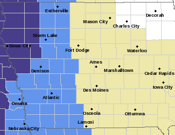
Frost Advisory for counties in light blue; Freeze Warning for counties in purple.
PRECAUTIONARY/PREPAREDNESS ACTIONS…
Take steps now to protect tender plants from the cold.
Today: Scattered showers, mainly before 8am. Cloudy through mid morning, then clearing, with a high near 55. Windy, with a northwest wind 20 to 25 mph, with gusts as high as 37 mph. Chance of precipitation is 30%.
Tonight: **Frost Advisory overnight** Areas of frost after 5am. Otherwise, mostly clear, with a low around 34. Northwest wind 7 to 14 mph, with gusts as high as 23 mph.
Saturday: **Frost Advisory through 9-a.m** Sunny, with a high near 59. West northwest wind 6 to 11 mph.
Saturday Night: Mostly clear, with a low around 37. Southwest wind around 6 mph.
Sunday: Sunny, with a high near 70.
Sunday Night: Mostly clear, with a low around 36.
Columbus Day: Sunny, with a high near 59.
Thursday’s High in Atlantic was 71. The Low was 43. We received .03″ of rain this morning (as of 7-a.m.). Last year on this date, the High in Atlantic was 69 and the Low was 38. The Record High for Oct. 6 in Atlantic was 91in 1963 & 1997, and the Record Low was 15, in 2012. Sunrise is at 7:22. Sunset at 6:54.
Today: Sunny, with a high near 71. Windy, with a northwest wind 5 to 10 mph increasing to 16 to 21 mph in the afternoon. Winds could gust as high as 28 mph.
Tonight: Mostly clear, with a low around 42. West wind 7 to 13 mph, with gusts as high as 20 mph.
Tomorrow: A 20 percent chance of showers before 11am. Mostly sunny, with a high near 53. Windy, with a northwest wind 14 to 24 mph, with gusts as high as 32 mph.
Tom. Night: Patchy frost after 3am. Otherwise, mostly clear, with a low around 32. Northwest wind 7 to 15 mph, with gusts as high as 22 mph.
Saturday: Areas of frost before 9am. Otherwise, sunny, with a high near 58.
Sunday: Areas of frost before 7am. Otherwise, sunny, with a high near 68.
Wednesday’s High in Atlantic was 71. The Low was 43. Last year on this date, the High in Atlantic was 75 and the Low was 43. The Record High for Oct. 5 in Atlantic was 93 in 1963, and the Record Low was 22, in 2012. Sunrise is at 7:20. Sunset at 6:55.
Today: Mostly sunny, with a high near 72. West northwest wind around 10 mph.
Tonight: Mostly clear, with a low around 48. West southwest wind 5 mph.
Tomorrow: Sunny, with a high near 71. Breezy, with a west southwest wind at 10-20 becoming northwesterly.
Friday: Mostly sunny & windy, w/a 30% chance of showers. High near 55.
Friday Night: Mostly clear & breezy, with a low around 34.
Saturday: Sunny, with a high near 57.
Tuesday’s High in Atlantic was 83. The Low was 61. We received .52″ rain overnight Tuesday into this (Wed.) morning. Last year on this date, the High in Atlantic was 83 and the Low was 50. The Record High for Oct. 4 in Atlantic was 90 in 1938 & 2005, and the Record Low was 20, in 1968. Sunrise is at 7:19. Sunset at 6:57.


