
MONONA-HARRISON-SHELBY-POTTAWATTAMIE-MILLS-MONTGOMERY-FREMONT- PAGE COUNTIES…354 AM CDT MON MAR 30 2015 …
RED FLAG WARNING IN EFFECT FROM NOON TODAY TO 7 PM CDT THIS EVENING DUE TO WIND AND LOW RELATIVE HUMIDITY FOR EASTERN NEBRASKA AND SOUTHWEST IOWA…
THE NATIONAL WEATHER SERVICE IN OMAHA/VALLEY HAS ISSUED A RED FLAG WARNING DUE TO WIND AND LOW RELATIVE HUMIDITY…WHICH IS IN EFFECT FROM NOON TODAY TO 7 PM CDT THIS EVENING.
* WINDS…WEST 10 TO 20 MPH WITH GUSTS AROUND 30 MPH. * RELATIVE HUMIDITY…AS LOW AS 16 PERCENT.
* IMPACTS…CONDITIONS THIS AFTERNOON WILL BE FAVORABLE FOR EXTREME FIRE BEHAVIOR WITH A HIGH POTENTIAL FOR OUT OF CONTROL BURNS.
PRECAUTIONARY/PREPAREDNESS ACTIONS…
A RED FLAG WARNING MEANS THAT CRITICAL FIRE WEATHER CONDITIONS ARE EITHER OCCURRING NOW…OR WILL SHORTLY.
Today: Wind Advisory from 10-a.m. thru late this afternoon/evening. Mostly Cloudy this morning; Gradually becoming sunny & windy. High near 62. S/SW winds 15-30 w/gusts to around 45 mph.
Tonight: Mostly clear & breezy. Low around 33. NW-W winds @ 15-25 diminishing to around 5-10 after midnight.
Monday: Sunny & breezy. High near 72. SW winds @ 10-20 mph gusting to near 30.
Monday Night: Mostly clear, with a low around 39. SW wind 5 to 15 mph becoming west northwest after midnight & gusting up to 20 mph.
Tuesday: Sunny, with a high near 73. North wind around 5-10 mph.
Tuesday Night: Mostly clear, with a low around 45.
Wednesday: A 40 percent chance of showers & thunderstorms after 1-pm, otherwise. Mostly sunny & windy. High near 75.
Saturday’s High in Atlantic was 50. Our Low was 32. We received .03″ rain overnight thru early Sunday morning, here at the KJAN studios. Last year on this date we reached 53 for a High, 26 was our Low. The All-Time Record High in Atlantic on March 29th was 90 in 1896. The Record Low was 5 in 1969. Sunrise today is at 7:09 and Sunset will be at 7:42.
Weather experts have been spending this past week preparing Iowans for springtime threats such as tornadoes, hail and lightning. National Weather Service meteorologist Todd Heitkamp is also trying to dispel the many myths associated with severe weather. For instance, lightning can strike twice in the same spot. “There’s no doubt that’s a myth,” Heitkamp says. “Lightning can strike as often as it wants to and more often than not, lightning will strike the same place multiple times.”
Some Iowans might believe it’s a good idea to open windows and seek shelter in the southwest corner of a home in event of a tornado. That’s not the best advice, according to Heitkamp.”We want people to seek shelter underneath something sturdy or in a small, interior room. Stay out of the corners because the corners are actually the worst possible places to be during a tornado,” Heitkamp says.
“Opening the windows — it makes no difference. If the tornado wants the windows open, believe me, it is going to open them whether you like it or not. You better utilize that time to get yourself and your family members to your place of safety.” Another common falsehood about tornadoes is they’ll never cross a body of water.
“Nothing stops a tornado other than the tornado itself,” Heitkamp says. “Tornadoes can cross bodies of water — lakes, rivers and streams.” Heitkamp says knowing the difference between weather myths and weather facts may help save your life. The past week was designated as Severe Weather Awareness Week.
(Radio Iowa)

Podcast: Play in new window | Download (775.7KB)
Subscribe: RSS
Today: Scattered flurries, mainly before 7am. Cloudy, then gradually becoming mostly sunny, with a high near 49. East southeast wind 5 to 14 mph.
Tonight: A slight chance of rain, mainly between 4am and 5am, then a chance of showers after 5am. Increasing clouds, with a low around 37. Breezy, with a south southeast wind 14 to 18 mph, with gusts as high as 26 mph. Chance of precipitation is 30%. New precipitation amounts of less than a tenth of an inch possible.
Sunday: A 40 percent chance of showers, mainly before 8am. Mostly cloudy, then gradually becoming sunny, with a high near 60. Windy, with a south southwest wind 15 to 25 mph becoming northwest in the afternoon. Winds could gust as high as 36 mph. New precipitation amounts of less than a tenth of an inch possible.
Sunday Night: Mostly clear, with a low around 35. Breezy, with a west northwest wind 13 to 18 mph decreasing to 6 to 11 mph after midnight. Winds could gust as high as 25 mph.
Monday: Sunny, with a high near 70. Breezy, with a southwest wind 7 to 16 mph, with gusts as high as 22 mph.
Tuesday: Sunny, with a high near 71.
Today: Increasing cloudiness. High near 45. North winds 5-10 becoming light and variable in the afternoon.
Tonight: A 50 percent chance of snow, mainly after 11pm. Low 29. SW wind around 5 mph becoming light and variable. New snow accumulation of less than a half inch possible.
Saturday: Cloudy w/a 10% chance of snow before 7am. Gradually becoming mostly sunny, with a high near 48. E/SE @ 5-15mph, with gusts as high as 20.
Sat. Night: Partly Cloudy w/a 40% chance of showers after midnight. Low 38. S @ 10-20. New precipitation amounts of less than a tenth of an inch possible.
Sunday: Partly Sunny & windy w/a 30% chance of showers. High near 58. S/SW @ 15-30. New precipitation amounts of less than a tenth of an inch possible.
Sunday Night: Mostly clear, with a low around 35.
Monday: Mostly sunny, with a high near 68.
Thursday’s High in Atlantic was 46. Our Low this morning, 19. We received a Trace of rainfall at the KJAN studios Thursday evening. Last year on this date we topped at 53 for our High and 32 was our Low. The All-Time Record High in Atlantic on March 27th, was 85 in 1895. The Record Low was 6 in 1894. Our sunrise today is at 7:11. Sunset will be at 7:39.
346 AM CDT FRI MAR 27 2015
EARLY THIS MORNING…PARTLY CLOUDY. NORTH WIND 5 TO 10 MPH.
TODAY…MOSTLY SUNNY UNTIL LATE AFTERNOON THEN BECOMING MOSTLY CLOUDY. HIGH IN THE LOWER 40S. NORTHWEST WIND NEAR 10 MPH.
TONIGHT…CLOUDY. A SLIGHT CHANCE OF LIGHT SNOW IN THE EVENING… THEN A CHANCE OF LIGHT SNOW OVERNIGHT. LOW AROUND 30. SOUTHEAST WIND NEAR 10 MPH. CHANCE OF SNOW 50 PERCENT.
SATURDAY…MOSTLY CLOUDY UNTIL LATE AFTERNOON THEN BECOMING MOSTLY SUNNY. HIGH AROUND 50. SOUTHEAST WIND 5 TO 15 MPH.
SATURDAY NIGHT…PARTLY CLOUDY THROUGH MIDNIGHT…THEN MOSTLY CLOUDY WITH A 40 PERCENT CHANCE OF LIGHT RAIN SHOWERS AFTER MIDNIGHT. LOW IN THE UPPER 30S. SOUTH WIND 10 TO 15 MPH WITH GUSTS TO AROUND 25 MPH.
SUNDAY…PARTLY SUNNY WITH A 30 PERCENT CHANCE OF LIGHT RAIN SHOWERS. BREEZY. HIGH AROUND 60. NORTHWEST WIND 10 TO 20 MPH WITH GUSTS TO AROUND 30 MPH.
MONDAY…MOSTLY SUNNY. HIGH IN THE UPPER 60S.
The Shelby County Emergency Management Agency says the Fire Danger Index will remain in the “Moderate” category, through next Monday. Officials say if you have a large burn, please notify your Fire Chief, prior to ignition. If you call the Emergency Mgmt. Agency at 712-755-2124 for assistance, if needed. 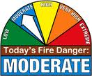
The EMA says you should “Always have a plan, Never leave a burning pile unattended , be aware of the direction and speed of the wind, and avoid smoking out neighbors or those who may have respiratory problems.”
Emergency Manager Bob Seivert says they expect the fire danger conditions to worsen next week.
The Freese-Notis forecast for the KJAN listening area and weather info. for Atlantic.
Podcast: Play in new window | Download (946.5KB)
Subscribe: RSS
404 AM CDT THU MAR 26 2015
EARLY THIS MORNING…MOSTLY CLEAR. NORTHWEST WIND 5 TO 10 MPH.
TODAY…MOSTLY SUNNY. HIGH IN THE UPPER 40S. NORTHWEST WIND 5 TO 15 MPH.
TONIGHT…MOSTLY CLOUDY THROUGH MIDNIGHT THEN BECOMING PARTLY CLOUDY. LOW IN THE LOWER 20S. NORTH WIND 5 TO 15 MPH.
FRIDAY…MOSTLY SUNNY UNTIL LATE AFTERNOON THEN BECOMING MOSTLY CLOUDY. HIGH IN THE MID 40S. NORTH WIND 5 TO 10 MPH.
FRIDAY NIGHT…CLOUDY WITH A 40 PERCENT CHANCE OF SNOW. LOW IN THE UPPER 20S. EAST WIND 5 TO 10 MPH.
SATURDAY…MOSTLY CLOUDY IN THE MORNING THEN BECOMING MOSTLY SUNNY. HIGH IN THE LOWER 50S. SOUTHEAST WIND 10 TO 15 MPH.
SATURDAY NIGHT…MOSTLY CLOUDY. A 20 PERCENT CHANCE OF RAIN AFTER MIDNIGHT. BREEZY. LOW IN THE MID 30S.
SUNDAY…PARTLY SUNNY WITH A 20 PERCENT CHANCE OF RAIN. BREEZY. HIGH AROUND 60.


