
Today: Partly sunny & windy. High near 65. S/SW winds @ 10-20 this morning gusting to near 40 this afternoon.
Tonight: Mostly cloudy w/a slight chance of rain this evening, then gradual clearing. Low around 29. W/SW winds 10-20 mph w/gusts as high as 25 mph. Chance of precipitation is 20%.
Tomorrow: Sunny, with a high near 47. North wind @ 5-10 mph becoming W/SW in the afternoon.
Tom. Night: Clear, with a low around 28. South southwest wind around 5 mph.
Saturday: Sunny, with a high near 58.
Saturday Night: Mostly clear, with a low around 32.
Sunday: Mo. Cldy w/a slight chance of rain after noon. High near 56.
Wednesday’s High in Atlantic was 69. The Low was 30. This day last year the high was 27 and the low 14. The record high for Nov. 16th in Atlantic was 73 in 2001. The record low was 1 in 1955. Sunrise is at 7:09 am and sunset is at 4:59 pm.
Today: Sunny, with a high near 69. Calm wind becoming southeast around 6 mph in the morning.
Tonight: Mostly clear, with a low around 45. South wind 6 to 13 mph, with gusts as high as 20 mph.
Tomorrow: Increasing clouds, with a high near 66. Windy, with a south southwest wind 14 to 24 mph, with gusts as high as 34 mph.
Tom. Night: Mostly cloudy, with a low around 29. Blustery, with a west southwest wind 13 to 16 mph becoming north in the evening. Winds could gust as high as 23 mph.
Friday: Sunny, with a high near 48.
Saturday: Sunny, with a high near 58.
Tuesday’s High in Atlantic was 69. The Low was 29. This day last year the high was 32 and the low 20. The record high for Nov. 15th in Atlantic was 75 in 2001. The record low was -7 in 1940. Sunrise is at 7:08 am and sunset is at 5:00 pm.
The National Weather Service issued a statement saying elevated fire weather conditions are expected…due to combination of windy conditions, low relative humidities, and cured agriculture fields and prairie grasses.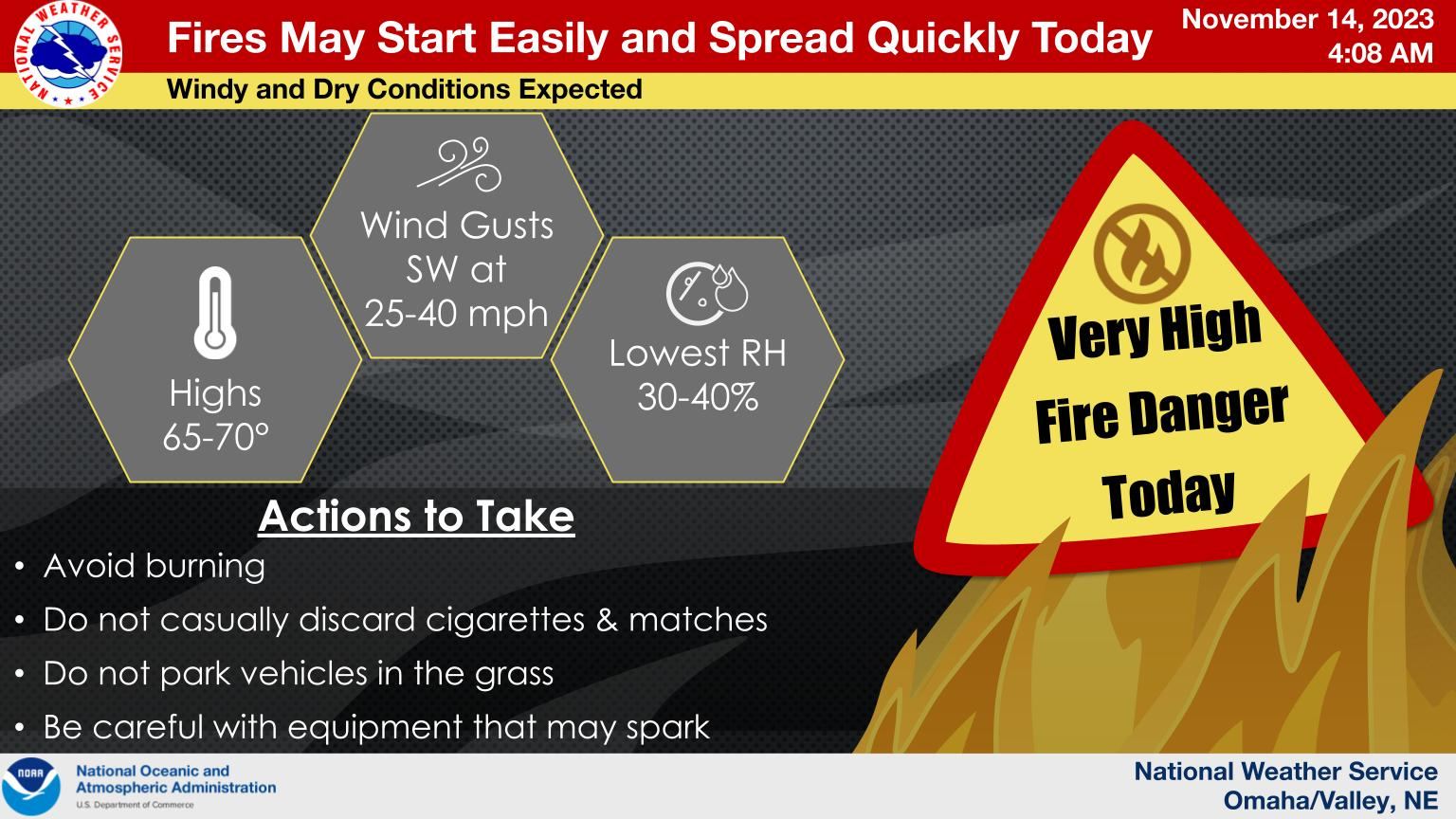 Strong and gusty winds, gusts up to 35 to 45 mph, will be experienced across eastern Nebraska and western Iowa today (Tuesday) through Thursday. Any fire that does start may spread quickly. The gusty winds may cause hazardous travel conditions for high profile vehicles on east west roadways, as well.
Today: Sunny & windy, with a high near 69. S/SW winds 10-20 mph w/gusts to around 30.
Tonight: Mostly clear & breezy, with a low around 40. SW winds @ 10-25 mph.
Tomorrow: Sunny, with a high near 69. South wind around 5-10 mph.
Thursday: Partly sunny & windy, with a high near 67.
Friday: Sunny & breezy, with a high near 50.
Monday’s High in Atlantic was 67. The Low was 24. This day last year the high was 43 and the low 28. The record high for Nov. 14th in Atlantic was 72 in 1897, 1964 & 1990. The record low was -5 in 1940. Sunrise is at 7:07 am and sunset is at 5:01 pm.
Today: Sunny, with a high near 66. Calm wind becoming south southeast 5 to 10 mph this afternoon.
Tonight: Clear, with a low around 38. South southeast wind 5 to 10 mph, with gusts to around 20 mph.
Tomorrow: Sunny & breezy, with a high near 66. S/SW winds 10-30 mph.
Tom. Night: Mostly clear & breezy. Low 41. S/SW @ 10-30 mph.
Wednesday: Sunny, with a high near 69.
Wed. Night: Partly cloudy & breezy, with a low around 45.
Thursday: Partly sunny & windy, with a high near 66.
Sunday’s High in Atlantic was 66. Our Low this morning was 24. This day last year the high was 38 and the low 11. The record high for Nov. 13th in Atlantic was 83 in 1999. The record low was -5 in 1940. Sunrise is at 7:06 am and sunset is at 5:02 pm.
Today: Sunny, with a high near 64. South wind 7 to 14 mph becoming west northwest in the afternoon. Winds could gust as high as 25 mph.
Tonight: Clear, with a low around 33. Northwest wind 3 to 6 mph.
Monday: Sunny, with a high near 63. Calm wind becoming south southeast 5 to 9 mph in the morning.
Monday Night: Clear, with a low around 38. South southeast wind 7 to 10 mph.
Tuesday: Sunny, with a high near 66. Breezy, with a south wind 9 to 14 mph increasing to 15 to 20 mph in the afternoon. Winds could gust as high as 25 mph.
Tuesday Night: Mostly clear, with a low around 42. Breezy.
Wednesday: Sunny, with a high near 66.
Saturday’s High in Atlantic was 53. The Low was 36. This day last year the high was 30 and the low 11. The record high for Nov. 12th in Atlantic was 73 in 2005. The record low was -4 in 1968 & 2019. Sunrise is at 7:05 am and sunset is at 5:03 pm.
Today – Veterans Day: Partly sunny, with a high near 54. Breezy, with a south wind 10 to 18 mph, with gusts as high as 28 mph.
Tonight: Mostly clear, with a low around 36. South wind 11 to 15 mph, with gusts as high as 25 mph.
Sunday: Sunny, with a high near 63. South southwest wind 7 to 13 mph becoming west in the afternoon. Winds could gust as high as 18 mph.
Sunday Night: Clear, with a low around 32. West northwest wind around 6 mph becoming north northeast after midnight.
Monday: Sunny, with a high near 63.
Monday Night: Mostly clear, with a low around 38. Breezy.
Tuesday: Sunny, with a high near 64. Breezy.
Friday’s High in Atlantic was 50. The Low was 22. This day last year the high was 30 and the low 17. The record high for Nov. 11th in Atlantic was 73 in 1964 & 2005. The record low was -10 in 1986. Sunrise is at 7:03 am and sunset is at 5:04 pm.
Today: Sunny, with a high near 49. Northwest wind 5 to 9 mph becoming light north northwest in the afternoon.
Tonight: Partly cloudy, with a low around 31. Light east southeast wind becoming south southeast 5 to 10 mph in the evening.
Veterans Day (Saturday): Mostly cloudy, with a high near 53. Breezy, with a south wind 10 to 16 mph, with gusts as high as 25 mph.
Saturday Night: Partly cloudy, with a low around 35. South wind 11 to 15 mph, with gusts as high as 22 mph.
Sunday: Sunny, with a high near 62.
Sunday Night: Clear, with a low around 32.
Monday: Sunny, with a high near 63.
Thursday’s High in Atlantic was 61. Our Low this morning was 22. This day last year the high was 68 and the low 17. The record high for Nov. 10th in Atlantic was 76 in 1927, and the record low was 3 in 1986. Sunrise is at 7:02 am and sunset is at 5:05 pm.
DES MOINES – October’s above-normal precipitation broke a streak of drier-than-normal months that began in March, according to the latest Water Summary Update.
October’s statewide average precipitation was 3.12 inches, or 0.43 inches above normal. The heavy rainfall in northwest Iowa led to an improvement to “normal” conditions according to the Iowa Drought Plan.
“The wetter-than-normal October was certainly very welcome in Iowa,” said Tim Hall, the DNR’s Hydrology Resources Coordinator. “Despite the above-normal rainfall in October, the state is still more than 7 inches short of moisture for this year, which is concerning as we wind down the fall and head into the winter months. We continue to need normal to above normal rainfall across nearly all of the state to get us into better shape headed into next spring.”
October rains resulted in some improvement in drought conditions for most of the state. However, southwest Iowa moved into the “drought warning” category due to a combination of precipitation deficits and streamflow, along with the current U.S. Drought Monitor designation of moderate to severe drought.
A small area of eastern Jackson, Clinton and Scott counties is the only part of Iowa currently not designated with any classification of dryness or drought.
For a thorough review of Iowa’s water resource trends, visit www.iowadnr.gov/watersummaryupdate.
The report is prepared by technical staff from Iowa DNR, the Iowa Department of Agriculture and Land Stewardship, IIHR—Hydroscience and Engineering, and the U.S. Geological Survey, in collaboration with Iowa Homeland Security and Emergency Management Department.
Today: Sunny & breezy with a high near 57. W @ 5-15 mph w/gusts to near 25 mph.
Tonight: Mostly clear, with a low around 28. West northwest wind 5 to 10 mph.
Tomorrow: Sunny, with a high near 49. W/NW @ 5-10 becoming northerly in the afternoon.
Veterans Day (Saturday): Partly sunny & breezy, with a high near 54.
Sunday: Sunny & breezy, with a high near 61.
Wednesday’s High in Atlantic was 67. Our Low this morning was 25. This day last year the high was 76 and the low 62. The record high for Nov. 9th in Atlantic was 76 in 2022, and the record low was 8 in 1973. Sunrise is at 7:01 am and sunset is at 5:06 pm.


