
Today: Increasing clouds w/a chance of flurries. High near 34. W/NW winds 10-20 mph. Wind chill values as low as 5.
Tonight: Mostly clear, with a low around 11. West northwest wind 5 to 10 mph becoming light and variable after midnight.
Tomorrow: Mostly sunny, with a high near 36. S/SW @ 10-20. Wind chill values as low as 5.
Tom. Night: Mostly clear, with a low around 20. South southwest wind 5 to 10 mph becoming west after midnight.
Wednesday: Sunny, with a high near 45.
Thursday: Mostly cloudy, with a high near 40.
Sunday’s High in Atlantic was 37. Our Low this morning was 6. Last year on this date, the High in Atlantic was 48, and the Low was 13. The Record High on Nov. 27th in Atlantic, was 69 in 1998. The Record Low was 1 in 1898. Sunrise is at 7:22. Sunset is 4:52.
Here are 24-hour reported snowfall amounts in southwest/western Iowa (ending 7-a.m. Sunday, 11/16/23):
Atlantic (KJAN) 2.0″
Atlantic (7 miles N/NE), 1.3″
Logan, .3″
Massena, 2.0″
Minden, 2.2″
Council Bluffs, 3.1″
New Market, 2.2″
Cromwell, 3.1″
Mondamin, .4″
Bagley, 1.0″
Brayton, 1.3″
Today: Partly sunny, with a high near 34. Wind chill values as low as 10. Windy, with a northwest wind 7 to 12 mph increasing to 17 to 22 mph in the afternoon. Winds could gust as high as 30 mph.
Tonight: Mostly clear, with a low around 14. Wind chill values as low as 5. West wind 7 to 14 mph, with gusts as high as 23 mph.
Tomorrow: Sunny, with a high near 34. Wind chill values as low as 5. West northwest wind 7 to 13 mph, with gusts as high as 20 mph.
Tom. Night: Mostly clear, with a low around 11. West northwest wind 3 to 7 mph.
Tuesday: Mostly sunny, with a high near 38.
Tuesday Night: Mostly clear, with a low around 22.
Wednesday: Sunny, with a high near 45.
Saturday’s High in Atlantic was 30. Our Low this morning was 19. We received 2 inches of snow at the KJAN studios from late Saturday morning through early Sunday. That melted into .15″ liquid value. Last year on this date, the High in Atlantic was 57, and the Low was 33. The Record High on Nov. 26th in Atlantic, was 69 in 1960. The Record Low was -9 in 1898. Sunrise is at 7:21. Sunset is 4:53.
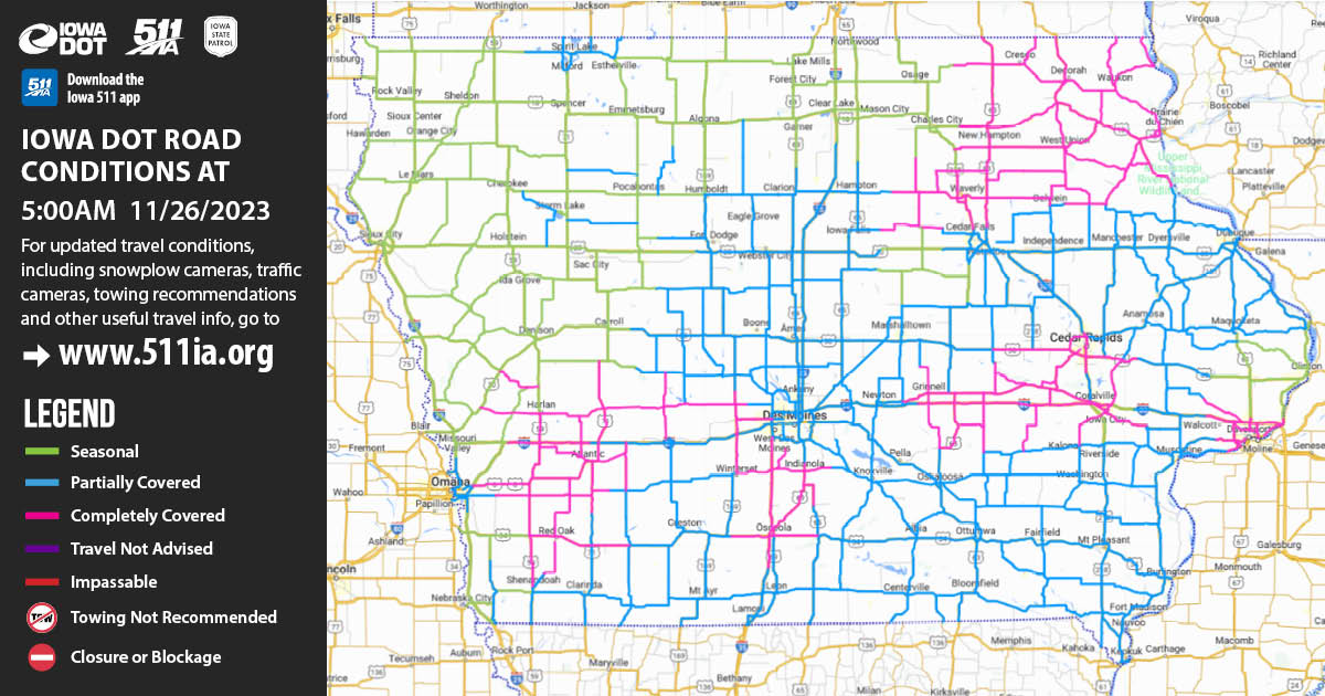
(Iowa DOT Road report, 11-26-23, 5 a.m.) – “We have nearly 300 plows out this morning, but roads are partially to completely covered in many parts of Iowa.
Winter driving skills are a must this morning:
![]() Check www.511ia.org or the Iowa 511 app for current conditions
Check www.511ia.org or the Iowa 511 app for current conditions
![]() Leave space between vehicles
Leave space between vehicles
![]() slow down
slow down
![]() pay attention
pay attention
![]() wear your seat belts.”
wear your seat belts.”
Friday’s High in Atlantic was 29. Our Low this morning, 20. Last year on this date, the High in Atlantic was 53, and the Low was 18. The Record High on Nov. 25th in Atlantic, was 71 in 1960. The Record Low was -6 in 1991. Sunrise is at 7:21. Sunset is 4:543.
Today: Cloudy, with a high near 30. NE winds 10-20 mph. Wind chill values as low as 10 degrees.
Tonight: Cloudy with a chance of flurries after midnight. Low around 22. East wind 5 to 10 mph.
Saturday: Mostly cloudy w/a 20% chance of snow after noon. High near 34. SE wind at around 5-10 mph becoming light and variable in the afternoon.
Sat.night: Mostly cloudy w/a 50% chance of snow. Low around 20. W/SW wind 5-10 mph. New snow accumulation of around an inch possible.
Sunday: Partly sunny & breezy, with a high near 37.
Sunday Night: Mostly clear & blustery, with a low around 11.
Monday: Sunny, with a high near 33.
Thursday’s High in Atlantic was 43. Our Low this morning, 20. Last year on this date, the High in Atlantic was 49, and the Low was 20. The Record High on Nov. 24th in Atlantic, was 68 in 2011. The Record Low was -2 in 1898. Sunrise is at 7:19. Sunset is 4:54.
Today (Thanksgiving Day): Mostly sunny & breezy, with a high near 40. N/NE winds 10-25 mph.
Tonight: Mostly cloudy, with a low around 21. N/NE wind 10-20 mph.
Friday: Mostly cloudy, with a high near 31. NE wind 10-20 mph.
Friday Night: Cloudy, with a low around 20. East wind 5 to 10 mph.
Saturday: Mostly cloudy, with a high near 33. East wind @ 5mph becoming west Saturday afternoon.
Sat. Night: A 30% chance of snow, mainly before midnight. Low around 17.
Sunday: Sunny & breezy, with a high near 37.
Sunday Night: Mostly clear & blustery, with a low around 14.
Monday: Sunny, with a high near 35.
Wednesday’s High in Atlantic was 51. Our Low was 18. Last year on this date, the High in Atlantic was 60, and the Low was 20. The Record High on Nov. 23rd in Atlantic, was 84 in 1953. The Record Low was -6 in 1898. Sunrise is at 7:18. Sunset is 4:54.
Today: Sunny & breezy with a high near 51. S/SW winds @ 10-20 mph w/gusts to near 25.
Tonight: Clear & breezy, with a low around 28. S/SW winds @ 10-20 mph.
Thanksgiving Day: Mostly sunny, with a high near 41. N/NE winds @ 10-20 mph.
Thu. Night: Mostly cloudy. Low around 20. N/NE winds 10-20 mph.
Friday: Mostly cloudy, with a high near 32.
Saturday: Mostly cloudy, with a high near 35.
Tuesday’s High in Atlantic was 43. Our Low this morning was 18. Last year on this date, the High in Atlantic was 60, and the Low was 15. The All-time Record High in Atlantic on Nov. 22nd, was 69 in 1966, and the Record Low was -10, in 1937. Sunrise today is at 7:16. Sunset is at 4:55.
Atlantic (KJAN), .10″
Elk Horn, .17″
Massena, .12″ (Ardelle McCunn reporting)
Cromwell (Union County), .12″
New Market (Taylor County), .17″
(Radio Iowa) – A few days ago, forecasters were warning of the possibility of snow on or around Thanksgiving, but now that we’re closer to the holiday, the foul weather is being removed from the list of likely options. Meteorologist Allan Curtis, at the National Weather Service, says if you’ll be on the road to visit family and friends for Thursday’s big meal, the roads should be dry. “At least for Iowa itself, we’ll say the driving weather is going to be pretty good for the holidays, Wednesday through Friday timeframe,” Curtis says. “There is some still some snow within the region but primarily to our west and maybe even off to our southwest, so think of it as Nebraska, Kansas areas.”
It’s predicted Thanksgiving Day should be mostly sunny in Iowa with highs in the 40s and lows in the 20s. Curtis says it’s expected to cool off this week, but that’s par for the season. “No more 60s or even upper 50s, at least for the coming few days, but all that being said, for entering mid to late November, it really isn’t too bad. It’s about average,” Curtis says. “We’re looking at highs in the mid to upper 40s for most of those travel days, Wednesday might be on the warm side in the 50s, and then after Thanksgiving, we drop down into the 30s for highs.” Many parts of Iowa got rain overnight Monday into Tuesday morning. It’s the first precipitation we’ve had since before Halloween.
“From [Monday] morning through the beginning of the month, we’ve really had zero rain across a lot of the state, so even if it’s light, it’s still the first rain we’ve seen this month,” Curtis says. “I don’t think there’s going to be too many people complaining, although I think many wish we could get a little bit more.” Keep up with the forecast on the kjan.com Weather page, or via the National Weather Service, at weather.gov.


