
Today: Sunny & windy, with a high near 68. South winds 10 to 20 mph.
Tonight: Increasing clouds. Low around 52. South winds 15 to 25 mph.
Monday: Partly sunny & windy, with a high near 77. South winds 15 to 30 mph.
Monday Night: Mostly cloudy & windy, with a low around 66. S @ 15-35 mph.
Tuesday: Mostly sunny & wind, with a high near 82. S @ 20-40 mph.
Tue. Night: A 40% chance of showers & thunderstorms late. Low around 56.
Wednesday: Showers likely along with possible thunderstorms. Windy. High near 68.
Saturday’s High in Atlantic was 62. The Low was 24. Last year on this date, the High in Atlantic was 42 and the Low was 25. The Record High for Oct. 27th in Atlantic was 87 in 1922. The Record Low was 9 in 1997. Sunrise today: 7:46; Sunset: 6:22.
Today: Sunny, with a high near 60. South/southeast wind 5 to 10 mph.
Tonight: Mostly cloudy during the early evening, then gradual clearing. Low around 36. S/SE wind around 5 mph.
Sunday: Sunny & breezy. High near 68. South wind 10 to 2 mph.
Sun.: Partly cloudy. Low around 52. South wind 10 to 25 mph.
Monday: Mostly cloudy & windy. High near 77.
Tuesday: Partly sunny & windy, with a high near 83.
Wednesday: Mostly cloudy w/a 60% chance of showers. High near 70.
Friday’s High in Atlantic was 63. The Low was 26. Last year on this date, the High in Atlantic was 71 and the Low was 38. The Record High for Oct. 26th in Atlantic was 84 in 1956. The Record Low was 14 in 1980. Sunrise today: 7:46; Sunset: 6:23.
Today: Sunny, with a high near 62. North winds 10-to 25-mph.
Tonight: Mostly clear, with a low around 30.
Tomorrow: Sunny, with a high near 60. S/SE winds 5-10.
Tom. Night: Partly cloudy, with a low around 37.
Sunday: Sunny, with a high near 68.
Sunday Night: Partly cloudy, with a low around 52.
Monday: Partly sunny & windy, with a high near 78.
Tuesday: Mostly sunny & windy, with a high near 83.
Thursday’s High in Atlantic was 72. The Low was 31. Last year on this date, the High in Atlantic was 66 and the Low was 57. The Record High for Oct. 25th in Atlantic was 66 in 1891 & 1940. The Record Low was 14 in 1892. Sunrise today: 7:42; Sunset: 6:24.
(Radio Iowa) – A map released this (Thursday) morning by the U-S Drought Monitor shows -all- of Iowa is again experiencing some level of drought. Last week’s map showed about two-and-a-half percent of the state was still in the normal category, but even that’s gone now. The new map indicates about 16-percent of Iowa is abnormally dry, all in south-central Iowa, while almost two-thirds of the state is in moderate drought. That leaves about 19-percent that’s in severe drought, with large patches of that category in northwest, west-central and northeast Iowa. As yet, none of the state’s in the worst two levels of extreme or exceptional drought. 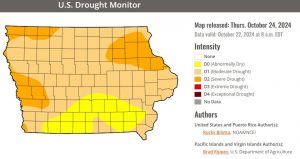
—-
A steady, soaking rain would be welcome, and not hail or high winds, but parts of Iowa may see all of them later today (Thursday). National Weather Service meteorologist Rod Donavon says the majority of Iowa is quite parched, so the expected downpour will be a refreshing change of pace. “We do have actually a pretty strong system coming into the state by later this afternoon, into this evening,” Donavon says. “We are expecting showers and thunderstorms to develop. It looks like in most areas, that development occurs sometime between 6 PM and midnight, and we may have a few strong storms, and we could have some large hail with those as well.”
While some areas are 50-50 for rainfall, parts of eastern Iowa are closer to a 100-percent chance for rain, though he says the quantities that are expected vary. “As you get up into the Webster City and Fort Dodge area, actually parts to the northwest might actually be our lower areas with the precipitation. They’re generally at around a 10th of an inch or so is the main forecast for there,” Donavon says. “Farther to the southeast, as you get south of Highway 30, basically Ames and Marshalltown, and east of I-35, there actually could be some areas that receive over an inch of rain.”
Dry conditions are expected to return for the weekend with highs in the 60s. The latest 6 to 10-day outlook shows a chance for more precipitation late next week.
Today: Partly cloudy to cloudy & breezy, w/a 20% chance of late day showers & thunderstorms. High near 72. S/SE winds 10-20 mph w/gusts to near 30.
Tonight: A 50% chance of showers & thunderstorms mainly before 10pm; Partly cloudy. Low around 44.
Tomorrow: Sunny, with a high near 62. North winds 10-mph.
Tom. Night: Mostly clear, with a low around 32.
Saturday: Sunny, with a high near 61.
Sunday: Sunny & breezy. High near 69.
Monday: Partly sunny & windy with a high near 79.
Wednesday’s High in Atlantic was 63. The Low was 31. Last year on this date, the High in Atlantic was 79 and the Low was 58. The Record High for Oct. 24th in Atlantic was 82 in 1891. The Record Low was 15 in 1999. Sunrise today: 7:42; Sunset: 6:26.
Today: Cloudy to partly cloudy. High near 64. North winds 5-to 10 mph w/gusts to near 20.
Tonight: Mostly clear, with a low around 40. S/SE winds 5-10 mph.
Tomorrow: Mostly sunny & breezy. There is a 40% chance of afternoon showers & thunderstorms. High near 74. S/SE @ 10-20 mph w/gusts to near 30. New rainfall amounts of less than a tenth of an inch, except higher amounts possible in thunderstorms.
Tom. Night: A 70% chance of showers & possibly a thunderstorm. Low around 45. New precipitation amounts between a tenth and quarter of an inch, except higher amounts possible in thunderstorms.
Friday: Sunny, with a high near 62.
Friday Night: Mostly clear, with a low around 32.
Saturday: Sunny, with a high near 62.
Sunday: Sunny, with a high near 66. Breezy.
Tuesday’s High in Atlantic was 75. The Low was 46. Last year on this date, the High in Atlantic was 81 and the Low was 56. The Record High for Oct. 23rd in Atlantic was 84 in 2022. The Record Low was 13 in 1895. Sunrise today: 7:40; Sunset: 6:27.
(Radio Iowa) – It wasn’t exactly a downpour but it was better than a sprinkle, as parts of Iowa saw measurable rainfall early this (Tuesday) morning for the first time in a long time. Meteorologist Brooke Hagenhoff, at the National Weather Service, says some precipitation is better than none, especially with about three-quarters of the state in moderate to extreme drought. “It certainly won’t be a drought buster,” Hagenhoff says, “but any kind of rain that we can see here is certainly a welcome sight.” In most areas of Iowa, the rain came well before dawn and lasted less than a half hour in many locations.
Hagenhoff says, “It looks like things have been light, generally under a 10th of an inch for most of the area, from western into central Iowa.” If you were holding off on washing your car until after the rain, you might want to wait until Friday. “We are looking at another chance of rain coming up on Thursday afternoon, maybe into Thursday night as well,” she says. “The location is a little uncertain at the moment, but it does look like generally central to eastern Iowa will be the big winners on that.”

Far from a ‘drought buster,’ but parts of Iowa see soaking rainfall (RI photo)
The latest U-S Drought Monitor map shows more than 97-percent of the state with at least abnormally dry conditions or some level of drought, and less than two-and-a-half percent in the normal range.
Today: Partly sunny-to sunny. High near 77. South winds 10-20 mph this morning becoming westerly this afternoon.
Tonight: Mostly clear, with a low around 46. W/NW winds 10-20 diminishing to around 5 mph.
Wednesday: Partly sunny-to sunny. High near 65. North wind around 5-10 mph.
Thursday: A 50% chance of afternoon showers & thunderstorms, otherwise mostly sunny & breezy. High 74.
Thu. Night: A 40% chance of showers & thunderstorms. Low around 42.
Friday: Sunny, with a high near 63.
Friday Night: Mostly clear, with a low around 33.
Saturday: Sunny, with a high near 62.
Monday’s High in Atlantic was 82. The Low was 55. We received .29″ rain overnight (Mon.-Tue.) at the KJAN studios Last year on this date, the High in Atlantic was 65 and the Low was 32. The Record High for Oct. 22nd in Atlantic was 87 in 1899. The Record Low was 15 in 1976. Sunrise today: 7:40; Sunset: 6:29.
(Radio Iowa) – Outdoor burning is now banned on 61 Iowa counties and fire departments in western, central and eastern Iowa have battled field fires in the past few days. Investigators have not determined the cause of a Thursday afternoon fire between Lake Park and Spirit Lake. Lake Park Fire Chief Brandon Ehret says luckily no homes or buildings caught fire. “When we got there…it had jumped the gravel road and was moving north at a high rate, probably burned about three-quarters of a mile north,” he says. “…Then we did some back burning to the grasslands to the south of it and basically got it stopped from going any farther north.”
The fire chief says the Little Sioux River was on the northeast side of the fire zone and the fire stopped at the river. “Three farmers had discs, got some fire lines to the north and on each side of it,” Ehret says, “so we were able to contain it that way as well.” The latest National Weather Service forecast indicates it will be dry, warm and breezy today (Monday) and there is a high or very high potential for grassland fires. 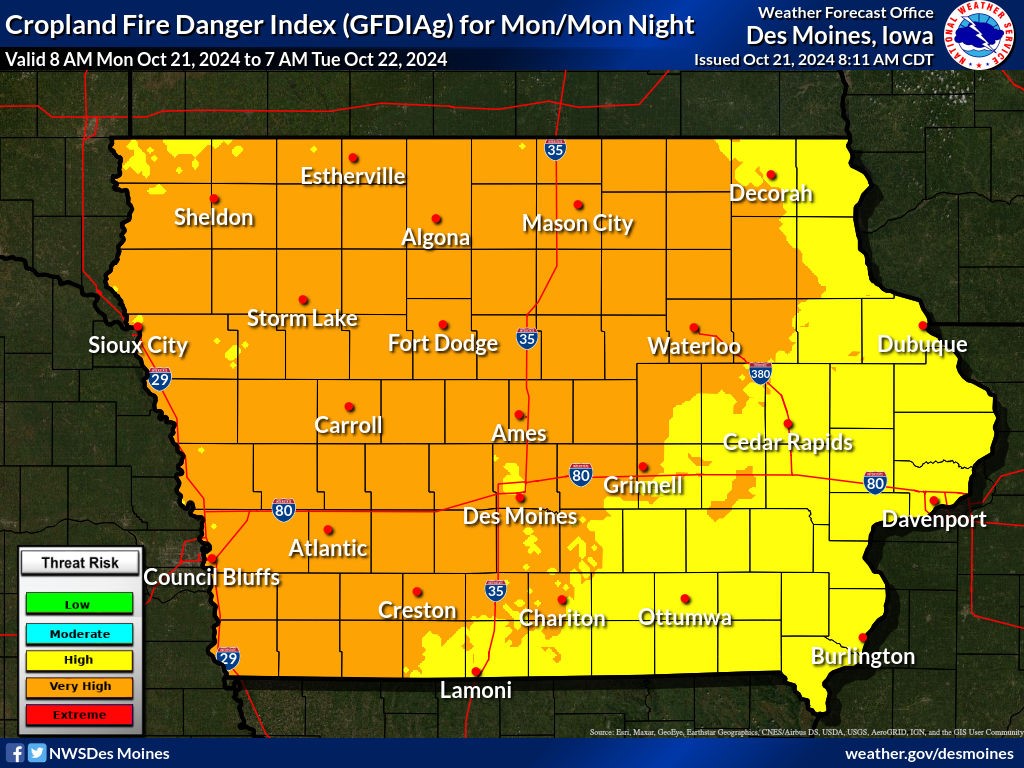
There is a chance for rain late this (Monday) afternoon and evening in some parts of the state.
Today: Sunny & breezy. High near 80. South winds @ 10-to 25 mph.
Tonight: A 50% chance of showers and thunderstorms late. Low around 55. S @ 10-25 mph.
Tomorrow: Partly-to-mostly sunny. High near 77. S/SE winds around 10 mph becoming west in the afternoon.
Tuesday Night: Mostly clear, with a low around 47.
Wednesday: Mostly sunny, with a high near 66.
Thursday: Sunny-to partly sunny, w/a slight chance of afternoon showers. High near 74.
Sunday’s High in Atlantic was 81. The Low was 53. Last year on this date, the High in Atlantic was 70 and the Low was 32. The Record High for Oct. 21st in Atlantic was 87 in 1947. The Record Low was 13 in 1930. Sunrise today: 7:38. Sunset: 6:30.


