
Today: Partly Cloudy. High 63. SE winds @ 10-15.
Tonight: P/Cldy to Cloudy. Low 46. SE @ 5-10.
Tomorrow: Cldy w/rain. High 53. E/SE @ 10-20.
Wednesday: P/Cldy w/a few sprinkles. High 50.
Thursday: P/Cldy. High 55.
Sunday’s High in Atlantic was 64. Our 24-hour Low ending at 7-a.m. today was 29. Last year on this date, our High was 76 and the Low was 46. The All-time Record High in Atlantic on Oct. 26th was 84 in 1956. The All-Time record low was 14 in 1980. Sunrise today is at 7:43, and sunset tonight will take place at 6:23.
342 AM CDT MON OCT 26 2015
EARLY THIS MORNING: MOSTLY CLEAR. SOUTHEAST WIND AROUND 5 MPH.
TODAY: MOSTLY SUNNY. HIGH IN THE MID 60S. SOUTHEAST WIND 5 TO 10 MPH.
TONIGHT: MOSTLY CLOUDY. LOW IN THE MID 40S. EAST WIND 5 TO 10 MPH.
TUESDAY: CLOUDY. A SLIGHT CHANCE OF LIGHT SHOWERS IN THE MORNING. THEN A CHANCE OF SHOWERS IN THE AFTERNOON. HIGH IN THE UPPER 50S. EAST WIND 5 TO 10 MPH. CHANCE OF SHOWERS 50 PERCENT.
TUESDAY NIGHT: MOSTLY CLOUDY WITH A 20 PERCENT CHANCE OF SHOWERS. LOW IN THE LOWER 40S. EAST WIND NEAR 5 MPH SHIFTING TO THE WEST AFTER MIDNIGHT.
WEDNESDAY: MOSTLY SUNNY. BREEZY. HIGH IN THE LOWER 50S. NORTHWEST WIND 10 TO 20 MPH WITH GUSTS TO AROUND 30 MPH.
THURSDAY: SUNNY. HIGH IN THE LOWER 50S.
242 AM CDT SUN OCT 25 2015
EARLY THIS MORNING…CLEAR…COLDER. SOUTHWEST WIND NEAR 5 MPH.
TODAY…SUNNY. HIGH IN THE MID 60S. SOUTH WIND NEAR 10 MPH.
TONIGHT…PARTLY CLOUDY. LOW AROUND 40. SOUTHEAST WIND 5 TO 10 MPH.
MONDAY…MOSTLY SUNNY. HIGH IN THE LOWER 60S. SOUTHEAST WIND 5 TO 10 MPH.
MONDAY NIGHT…MOSTLY CLOUDY. LOW IN THE MID 40S. SOUTHEAST WIND 5 TO 10 MPH.
TUESDAY…MOSTLY CLOUDY WITH A 50 PERCENT CHANCE OF SHOWERS. HIGH IN THE UPPER 50S. SOUTHEAST WIND 5 TO 10 MPH.
TUESDAY NIGHT…CLOUDY WITH A 50 PERCENT CHANCE OF LIGHT SHOWERS. LOW IN THE MID 40S.
WEDNESDAY…PARTLY SUNNY WITH A 20 PERCENT CHANCE OF LIGHT SHOWERS. HIGH IN THE LOWER 50S.
DES MOINES, Iowa (AP) — A band of storms produced some sightings of tornadoes in northwest Iowa Friday night, but there were no reports of injuries or significant damage. Kathy Stodola is duty officer for the Iowa emergency management department. She says that there was a report Friday evening of a roof torn off a building in Cherokee county.
The National Weather service says it received four reports of tornadoes, three in Sioux county and one in Cherokee county. Stodola said she expected the weather service to do an evaluation on the ground after daylight today (Saturday).

Podcast: Play in new window | Download (478.2KB)
Subscribe: RSS
Today: Showers and possibly a thunderstorm. High near 67. S @ 15-25. New rainfall amounts between a tenth and quarter of an inch, except higher amounts possible in thunderstorms.
Tonight: Cloudy to Partly Cloudy w/showers and thunderstorms mainly before 10pm. Low around 47. Winds becoming NW @ 10-15. New precipitation amounts of less than a tenth of an inch, except higher amounts possible in thunderstorms.
Saturday: Mostly sunny & breezy. High near 62. NW @ 15-25.
Sat. Night: Mostly clear. Low around 37.
Sunday: Partly Cloudy. High near 68.
Monday: Partly to Mostly sunny, with a high near 66.
Thursday’s High in Atlantic was 66. Our 24-hour Low (ending today at 7-a.m.), was 50. We received .23” of rain overnight into early this morning (through 7-a.m.) here at the KJAN studios. Last year on this date, our High was 74 and the Low was 43. The All-time record High for Atlantic on Oct. 23rd, was 81 in 1901 & 1991. The All-time record Low of 13 was set in 1895.
Early This Morning: Showers. Southeast wind 10 to 15 mph. Chance of showers 80 percent.
Today: Cloudy. Showers and isolated thunderstorms in the morning… Then scattered showers and isolated thunderstorms in the afternoon. High in the upper 60s. South wind 10 to 15 mph with gusts to around 25 mph. Chance of precipitation 90 percent.
Tonight: Mostly cloudy. A chance of showers and isolated thunderstorms through midnight. Low in the upper 40s. Southwest wind 10 to 15 mph shifting to the northwest after midnight. Chance of precipitation 50 percent.
Saturday: Mostly sunny. High in the lower 60s. Northwest wind 10 to 15 mph with gusts to around 25 mph.
Saturday Night: Mostly clear. Colder. Low in the upper 30s. North wind near 10 mph.
Sunday: Sunny. High in the mid 60s. South wind near 10 mph.
Monday: Partly sunny. High in the lower 60s.
With recent rain and the forecast for showers or light rain in the immediate forecast, the Shelby County Emergency Management Agency is asking local fire departments and businesses in the county who possess “Fire Danger” signs, to place those signs in the “High” category, through the weekend. That’s downgraded from Monday’s “Extreme” rating. Officials say another factor in the decision to lower the danger index, is the number of fields left to harvest, has dwindled.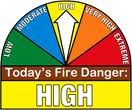
The next update on fire danger conditions will be posted Monday morning.
Today: Isolated sprinkles thru 9-am; A chance of light rain this afternoon, otherwise Cloudy, with a high near 63. East northeast wind 5 to 15 mph.
Tonight: Cloudy w/a 70% chance of showers and possibly a thunderstorm, especially after midnight. Low around 57. E/SE wind 10 to 15mph, with gusts as high as 20.
Friday: An 80% chance of showers & thunderstorms. High near 68. SE @ 15-25.
Friday Night: Mostly cloudy w/a 30% chance of showers through midnight. Low around 48. S/SW winds 10-15mph becoming W/NW after midnight.
Saturday: Mostly sunny, with a high near 64.
Sunday: Sunny, with a high near 68.
Wednesday’s High in Atlantic was 69. Our 24-hour Low ending at 7-a.m. today was 50. We received .10” (one-tenth of an inch) of rain the past 24-hours (.09 yesterday morning, .01 this morning). Last year on this date, our High was 70 and the Low was 50. The All-time Record High in Atlantic on Oct. 22nd was 87 in 1899. The All-Time record low was 15 in 1976. Sunrise today is at 7:40, and sunset tonight will take place at 6:29.


