
SPECIAL WEATHER STATEMENT NATIONAL WEATHER SERVICE DES MOINES IA 1248 PM CST SUN FEB 28 2016
EMMET-KOSSUTH-WINNEBAGO-WORTH-PALO ALTO-HANCOCK-CERRO GORDO- POCAHONTAS-HUMBOLDT-WRIGHT-FRANKLIN-BUTLER-BREMER-SAC-CALHOUN- WEBSTER-HAMILTON-HARDIN-GRUNDY-BLACK HAWK-CRAWFORD-CARROLL-GREENE- BOONE-STORY-MARSHALL-TAMA-AUDUBON-GUTHRIE-DALLAS-POLK-JASPER- POWESHIEK-CASS-ADAIR-MADISON-WARREN-MARION-MAHASKA-ADAMS-UNION– CLARKE-LUCAS-MONROE-WAPELLO-TAYLOR-RINGGOLD-DECATUR-WAYNE- APPANOOSE-DAVIS COUNTIES… …GUSTY NORTHWEST WINDS WILL CONTINUE THIS AFTERNOON…
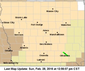
Wind Advisory until 4-p.m. for counties in brown.
NORTHWEST WINDS OF 25 TO 30 MPH WITH GUSTS IN EXCESS OF 40 MPH WILL CONTINUE THIS AFTERNOON AS A COLD FRONT MOVES THROUGH THE STATE. THESE WINDS MAY IMPACT DRIVING CONDITIONS IN RURAL AREAS.
A WIND ADVISORY CONTINUES UNTIL 4-P.M. FOR MONONA-HARRISON-SHELBY-POTTAWATTAMIE-MILLS COUNTIES.
Today: Mostly sunny. Windy…cooler. High in the mid 50s. West wind 10 to 20 mph increasing to northwest 20 to 30 mph in the afternoon. Gusts up to 40 mph.
**Wind Advisory from 8am-4pm for Monona-Harrison-Shelby-Pottawattamie- and Mills Counties**
Tonight: Mostly clear. Colder. Low in the lower 30s. West wind 5 to 10 mph with gusts to around 25 mph shifting to the southwest after midnight.
Monday: Mostly sunny until late afternoon then becoming mostly cloudy. Breezy. High in the upper 50s. Southwest wind 10 to 20 mph shifting to the northwest 10 to 15 mph in the afternoon. Gusts up to 30 mph.
Monday Night: Cloudy. A chance of light rain through midnight… Then a chance of light snow and a slight chance of light rain after midnight. Low in the mid 20s. Northeast wind 10 to 15 mph. Chance of precipitation 40 percent.
Tuesday: Mostly sunny. Much colder. High in the mid 30s. North wind 10 to 15 mph with gusts to around 25 mph.
Wednesday: Partly sunny. Warmer. High in the mid 40s.
MONONA-HARRISON-SHELBY-POTTAWATTAMIE-MILLS COUNTIES: A WIND ADVISORY IS IN EFFECT FROM 8 AM TODAY (SUNDAY) UNTIL 4 PM.
NORTHWEST WINDS WILL BE INCREASING FROM 25 TO 35 MPH, WITH GUSTS UP TO 50 MPH POSSIBLE.
THE STRONG WINDS WILL CREATE POTENTIALLY HAZARDOUS DRIVING CONDITIONS.
PRECAUTIONARY/PREPAREDNESS ACTIONS…
A WIND ADVISORY MEANS THAT SUSTAINED WIND SPEEDS BETWEEN 30 TO
39 MPH OR GUSTS BETWEEN 45 TO 57 MPH ARE EXPECTED. WINDS THIS
STRONG CAN MAKE DRIVING DIFFICULT…ESPECIALLY FOR HIGH PROFILE
VEHICLES. USE EXTRA CAUTION.
The Adair and Guthrie County Emergency Management Agencies will host a joint 2016 Storm Spotter Class at the Menlo Community Center, beginning at 7:00 PM on March 16th. Robert Kempf, Coordinator for the agencies, says the class is free and open to the public.
The following week, March 21st-throught the 25th, is Severe Weather Awareness Week in Iowa. The highlight of Severe Weather Awareness Week is the annual statewide tornado drill scheduled for 10-a.m. Wednesday, March 23rd. Schools, businesses, state and local governments, and individuals are strongly encouraged to participate in the drill. Additional information about the tornado drill can be found on local National Weather Service (NWS) website.
During Severe Weather Awareness Week, the Iowa Department of Homeland Security and Emergency Management will post information on individual and family preparedness at www.BeReady.iowa.gov, including podcasts, public service announcements and videos. The NWS will promote severe weather safety on their websites and by issuing informative public information statements.
Today: Sunny & breezy. High near 65. SW winds 10-20mph w/gusts to near 30.
Tonight: Mostly clear & breezy. Low around 42. S/SW @ 10-25mph.
Sunday: Mostly sunny & windy. High near 55. W/NW @ 15-35 during the afternoon.
Sunday Night: Mostly clear, with a low around 32. NW @ 10-20.
Monday: Partly sunny & breezy. High near 59. S/SW winds @ 10-20 in the morning becoming northerly @ 15-30 during the afternoon
Mon. Night: Cloudy w/a 30% chance rain or snow. Low around 28.
Tuesday: A 30% chance of snow, mainly before noon, otherwise Partly sunny & breezy. High 35.
Friday’s High in Atlantic was 50. The 24-hour Low ending at 7-a.m. today was 21. Last year on this date we reached 20 for a High and -13 was the low. The All-time Record High in Atlantic on this date was 68 in 1976. The Record Low was -16 in 1960.
EARLY THIS MORNING…CLEAR. SOUTHWEST WIND 5 TO 10 MPH.
TODAY…SUNNY…BREEZY…WARMER. HIGH IN THE MID 60S. SOUTHWEST WIND 5 TO 15 MPH INCREASING TO 15 TO 20 MPH IN THE AFTERNOON. GUSTS UP TO 30 MPH.
TONIGHT…MOSTLY CLEAR. NOT AS COOL. LOW IN THE LOWER 40S. SOUTHWEST WIND 10 TO 15 MPH WITH GUSTS TO AROUND 30 MPH.
SUNDAY…MOSTLY SUNNY. BREEZY…COOLER. HIGH IN THE MID 50S. NORTHWEST WIND 10 TO 25 MPH WITH GUSTS TO AROUND 35 MPH.
SUNDAY NIGHT…MOSTLY CLEAR. COLDER. LOW IN THE LOWER 30S. WEST WIND NEAR 10 MPH SHIFTING TO THE SOUTHWEST AFTER MIDNIGHT. GUSTS UP TO 25 MPH.
MONDAY…PARTLY SUNNY. BREEZY. HIGH IN THE UPPER 50S. SOUTHWEST WIND 10 TO 20 MPH SHIFTING TO THE NORTHWEST IN THE AFTERNOON. GUSTS UP TO 30 MPH.
MONDAY NIGHT…CLOUDY. A CHANCE OF LIGHT RAIN THROUGH MIDNIGHT, THEN A CHANCE OF LIGHT RAIN AND LIGHT SNOW AFTER MIDNIGHT. LOW IN THE UPPER 20S. CHANCE OF PRECIPITATION 30 PERCENT.
TUESDAY…CLOUDY. A CHANCE OF SNOW IN THE MORNING…THEN A SLIGHT CHANCE OF SNOW IN THE AFTERNOON. MUCH COLDER. HIGH IN THE MID 30S. CHANCE OF SNOW 30 PERCENT.
Today: Partly Cloudy. High 47. SW @ 10.
Tonight: P/Cldy. Low 28. SW @ 5
Tomorrow: P/Cldy. High 64.
Sunday: P/Cldy to Cldy. High 52.
Monday: P/Cldy. High 59.
Thursday’s High in Atlantic was 36. The 24-hour Low ending at 7-a.m. today was 19. Last year on this date we reached 13for a High and -13 was the low. The All-time Record High in Atlantic on this date was 72 in 1896. The Record Low was -28 in 1963.
Early This Morning: Partly cloudy. Southwest wind near 5 mph.
Today: Mostly sunny. Warmer. High around 50. Southwest wind 5 to 15 mph.
Tonight: Mostly clear. Low in the lower 30s. Southwest wind 5 to 10 mph.
Saturday: Sunny…breezy…warmer. High in the mid 60s. Southwest wind 5 to 15 mph increasing to 15 to 20 mph with gusts to around 30 mph in the afternoon.
Saturday Night: Mostly clear. Breezy. Not as cool. Low in the mid 40s. Southwest wind 15 to 20 mph with gusts to around 30 mph.
Sunday: Partly sunny with a 20 percent chance of light rain. Breezy. High in the mid 50s. Northwest wind 15 to 25 mph with gusts to around 35 mph.
Sunday Night: Partly cloudy. Colder. Low in the lower 30s.
Monday: Mostly sunny. High in the upper 50s.
Today: Mo. Cldy this morning w/a chance of flurries: P/Cldy this afternoon. High 39. N @ 15-25.
Tonight: P/Cldy. Low around 20.
Tomorrow: P/Cldy & breezy. High 46. SW @ 10.
Saturday: P/Cldy & breezy High around 62.
Sunday: P/Cldy & windy. High around 54.
Wednesday’s High in Atlantic was 39. The 24-hour Low ending at 7-a.m. today was 27. Last year on this date we reached 44 for a High and -3 was the low. The All-time Record High in Atlantic on this date was 70 in 1995. The Record Low was -12 in 2014.
EARLY THIS MORNING…PARTLY CLOUDY. ISOLATED FLURRIES. NORTHWEST WIND 10 TO 15 MPH.
TODAY…MOSTLY CLOUDY. BREEZY. HIGH IN THE UPPER 30S. NORTHWEST WIND 10 TO 20 MPH WITH GUSTS TO AROUND 30 MPH.
TONIGHT…PARTLY CLOUDY. LOW IN THE MID 20S. WEST WIND 5 TO 10 MPH.
FRIDAY…MOSTLY SUNNY. WARMER. HIGH IN THE UPPER 40S. SOUTHWEST WIND 5 TO 15 MPH.
SATURDAY…SUNNY…BREEZY…WARMER. HIGH IN THE LOWER 60S. SOUTHWEST WIND 5 TO 15 MPH INCREASING TO 15 TO 20 MPH IN THE AFTERNOON.
SUNDAY…PARTLY SUNNY. BREEZY. HIGH IN THE UPPER 50S.


