
Today: Partly Cloudy. High around 70. SW @ 15-25 this morning becoming NE this afternoon.
Tonight: Mostly cloudy w/light rain, mainly after midnight. Low 48. E @ 10-20.
Tomorrow: Cldy w/a 70% chance of showers. High near 52. E @ 15-30.
Wed. Night: Rain changing over to snow, w/patchy blowing snow. Low 28. N/NW @ 25-40. New snow accumulation of less than one inch possible.
Thursday: Cldy to P/Cldy & windy, w/light snow ending in the morning. High near 40. N/NW winds @ 15-30.
Friday: P/Cldy. High 56.
Monday’s High in Atlantic was 65. The 24-hour Low ending at 7-a.m. today was 26. Last year on this date, our High in Atlantic was 72, and the low was 30. The All-time Record High in Atlantic on this date was 86 in 1910. The Record Low was -6 in 1912.
Early this morning: Partly cloudy. Not as cool. Low in the lower 40s. South wind 10 to 15 mph with gusts to around 25 mph.
Today: Partly sunny. High around 70. South wind 10 to 15 mph with gusts to around 25 mph.
Tonight: Mostly cloudy then becoming partly cloudy before midnight then becoming mostly cloudy. Low in the upper 40s. East wind 5 to 10 mph.
Wednesday: Mostly cloudy. A chance of light showers in the morning…then light showers likely and a chance of thunderstorms in the afternoon. Breezy…cooler. High in the mid 50s. East wind 10 to 15 mph with gusts to around 25 mph shifting to the northeast 15 to 25 mph with gusts to around 35 mph in the afternoon. Chance of precipitation 60 percent.
Wednesday Night: Rain likely with possible thunderstorms and snow through midnight…then a chance of light snow after midnight. Windy…colder. Light snow accumulations possible. Low in the upper 20s. North wind 20 to 30 mph with gusts to around 40 mph. Chance of precipitation 80 percent.
Thursday: Mostly cloudy. Breezy…colder. High in the upper 30s.
Friday: Partly sunny. Warmer. High in the mid 50s.
Officials with the National Weather Service in Des Moines have confirmed the Statewide Tornado Drill Scheduled for Wednesday, March 23rd, has been postponed until Thursday, due to the possibility of severe weather across the state, on Wednesday. The Test Tornado Watch will now be issued at 10-a.m. Thursday, with a Test Tornado Warning issued at 10:20-a.m. Thursday, and the all-clear between 10:30 and 10:30-a.m. The Test Tornado Watch will expire at 11-a.m. Thursday. Again, the Statewide Tornado Drill has been postponed until Thursday.
Bob Seivert, Emergency Management Coordinator in Shelby County, reports the field and grass fire danger category will remain “High” this week. Drying conditions, with minimal precipitation in the forecast, along with increasing daytime winds, means the risk for controlled/planned burns, could quickly spread beyond the intended area. Therefore, any outdoor burns should be conducted during the early morning and late evening hours.
Fire stations and businesses in Shelby County should leave their Fire Danger” signs in the “High” category, through at least Thursday, when the next update on burning conditions will be provided. 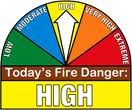
The Shelby County EMA says you should remember to call your controlled burns in to the EMA Communications center at (712) – 755-2124, and, contact your local Fire Chief before igniting any outdoor burns.
Today: Partly Cloudy. High 61. S @ 10-20
Tonight: P/Cldy. Low 42. SW @ 10-15.
Tomorrow: P/Cldy. High near 70. SW winds becoming NE @ 10-20.
Wednesday: Cldy w/showers & possible thunderstorms. High 52.
Thursday: Cldy w/light snow in the morning. High near 40.
Sunday’s High in Atlantic was 45. The 24-hour Low ending at 7-a.m. today was 19. Last year on this date, our High in Atlantic was 62, and the low was 36. The All-time Record High in Atlantic on this date was 88 in 1907. The Record Low was -7 in 1960.
This is the first full day of spring and it’s also the start of Severe Weather Awareness Week. Meteorologist Kelsey Angle, with the National Weather Service, says each day through Friday, they’ll center on a different topic to help Iowans prepare for the stormy seasons ahead. Angle says today’s (Monday) focus will be on severe thunderstorms.
“Tuesday’s more about preparedness and developing a plan,” Angle says. “On Wednesday, it’s executing that plan with a test tornado drill. On Thursday, we’ll talk more about preparedness and then on Friday, we wrap the week up with flash flooding.” Snow, ice and blizzards should be behind us now, with the months ahead being punctuated by hail, high winds, flash flooding, thunderstorms and tornadoes.
Angle says, “This is the time to really think about in case severe weather strikes your area, and it will at some point during the spring or summer, to have a plan and know where you would go to seek shelter and remain safe.” Learn more at www.weather.gov.
(Radio Iowa)
Early This Morning: Mostly clear. South wind near 5 mph.
Today: Sunny…breezy…warmer. High in the lower 60s. South wind 5 to 10 mph increasing to 20 to 25 mph in the afternoon.
Tonight: Mostly clear. Breezy. Not as cool. Low in the mid 40s. Southwest wind 10 to 20 mph with gusts to around 30 mph.
Tuesday: Partly sunny. High around 70. Southwest wind 5 to 15 mph with gusts to around 25 mph.
Tuesday Night: Mostly cloudy. A 20 percent chance of rain after midnight. Low in the upper 40s. East wind 5 to 15 mph.
Wednesday: Mostly cloudy. A chance of showers and isolated thunderstorms in the morning…then showers and isolated thunderstorms in the afternoon. Breezy…cooler. High in the mid 50s. Northeast wind 15 to 25 mph. Chance of precipitation 90 percent.
Today: Partly sunny, with a high near 43. North wind 5 to 10 mph.
Tonight: Mostly clear, with a low around 27.
Monday: Sunny & windy, with a high near 60. S @ 10-20mph with gusts to near 30 mph.
Monday Night: Mostly clear, with a low around 43. South southwest wind 10 to 15 mph.
Tuesday: Partly sunny, with a high near 71. South southwest wind 10 to 15 mph.
Tuesday Night: Mostly cloudy, with a low around 48.
Wednesday: Mostly cloudy & breezy, w/a 50% chance of showers and thunderstorms. High near 63.
Saturday’s High in Atlantic was 41. We received .3” of snow yesterday at the KJAN studios, which melted into .07″ of liquid precipitation. The 24-hour Low ending at 7-a.m. today was 24. Last year on this date, our High in Atlantic was 66, and the low was 24. The All-time Record High in Atlantic on this date was 80 in 1938. The Record Low was -7 in 1906.
Early This Morning: Mostly cloudy. North wind 10 to 15 mph with gusts to around 25 mph.
Today: Partly sunny. High in the lower 40s. Northwest wind 10 to 15 mph.
Tonight: Mostly clear. Low in the upper 20s. West wind near 5 mph shifting to the south after midnight.
Monday: Sunny…breezy…warmer. High around 60. South wind 5 to 15 mph increasing to 15 to 20 mph in the afternoon. Gusts up to 30 mph.
Tuesday: Partly sunny. Warmer. High in the lower 70s. Southwest wind 10 to 15 mph.
Wednesday: Mostly cloudy with a chance of showers and isolated thunderstorms. High in the lower 60s. Chance of precipitation 50 percent.
Today: Cloudy & breezy, w/scattered snow showers thru about noon, then rain and snow showers are likely. High near 39. NW @ 10-20mph, gusting to around 25. Total daytime snow accumulation of less than a half inch possible.
Tonight: Cloudy w/a slight chance of rain & snow showers thru about 9-p.m, then gradually becoming partly cloudy. Low around 25. N/NW @ 10-15.
Sunday: Mostly sunny, with a high near 44. North northwest wind 5 to 10 mph.
Sunday Night: Partly cloudy, with a low around 29.
Monday: Sunny & breezy, with a high near 61. S @ 10-20mpg w/gusts to near 25.
Monday Night: Partly cloudy, with a low around 44.
Tuesday: Partly sunny, with a high near 70.
Friday’s High in Atlantic was 45. The 24-hour Low ending at 7-a.m. today was 26. Last year on this date, our High in Atlantic was 48, and the low was 27. The All-time Record High in Atlantic on this date was 79 in 1976. The Record Low was -14 in 1923.


