
Early This Morning: Cloudy with a 50 percent chance of light rain…light freezing rain and light snow. Windy…colder. Northeast wind 20 to 30 mph with gusts to around 40 mph.
Today: Cloudy with a chance of light snow through mid morning… Then cloudy with a slight chance of light snow before noon. Partly sunny in the afternoon. Windy…colder. High in the upper 30s. North wind 25 to 30 mph decreasing to 15 to 25 mph in the afternoon. Gusts up to 40 mph. Chance of snow 50 percent.
Tonight: Mostly clear. Low in the mid 20s. Northwest wind 5 to 10 mph with gusts to around 25 mph shifting to the southwest after midnight.
Friday: Mostly sunny. Breezy…warmer. High in the mid 50s. South wind 5 to 15 mph increasing to 15 to 20 mph in the afternoon.
Friday Night: Mostly cloudy. A 20 percent chance of light rain after midnight. Not as cool. Low in the upper 30s. South wind 5 to 15 mph.
Saturday: Mostly cloudy. A chance of light rain and a slight chance of light snow in the morning…then a slight chance of light rain in the afternoon. High in the upper 40s. West wind near 10 mph increasing to north with gusts to around 25 mph in the afternoon. Chance of precipitation 40 percent.
Sunday: Partly sunny. High in the upper 40s.
THE NATIONAL WEATHER SERVICE HAS CANCELLED TORNADO WATCH 51 FOR THE FOLLOWING AREAS:
IN IOWA THIS CANCELS 4 COUNTIES…
FREMONT MILLS MONTGOMERY PAGE
MONTGOMERY IA-PAGE IA-635 PM CDT WED MAR 23 2016
…THE SEVERE THUNDERSTORM WARNING FOR SOUTHERN MONTGOMERY AND CENTRAL PAGE COUNTIES WILL EXPIRE AT 645 PM CDT…
THE STORM WHICH PROMPTED THE WARNING HAS WEAKENED BELOW SEVERE LIMITS AND EXITED THE WARNED AREA. THEREFORE THE WARNING WILL BE ALLOWED TO EXPIRE.
A TORNADO WATCH REMAINS IN EFFECT UNTIL 1000 PM CDT FOR SOUTHWESTERN IOWA.
636 PM CDT WED MAR 23 2016
THE NATIONAL WEATHER SERVICE IN DES MOINES HAS ISSUED A
* SEVERE THUNDERSTORM WARNING FOR…
TAYLOR COUNTY IN SOUTHWESTERN IOWA…
SOUTHWESTERN ADAMS COUNTY IN SOUTHWESTERN IOWA…
* UNTIL 715 PM CDT
* AT 636 PM CDT…A SEVERE THUNDERSTORM WAS LOCATED 4 MILES WEST OF
HOPKINS MISSOURI…OR 11 MILES SOUTHWEST OF BEDFORD…MOVING
NORTHEAST AT 45 MPH.
HAZARD…QUARTER SIZE HAIL.
SOURCE…RADAR INDICATED.
IMPACT…DAMAGE TO VEHICLES IS EXPECTED.
* LOCATIONS IMPACTED INCLUDE…
CORNING…BEDFORD…LENOX…LAKE ICARIA…NEW MARKET…CLEARFIELD…
GRAVITY…NODAWAY…SHARPSBURG…CONWAY…CARBON…LAKE ICARIA STATE
PARK…CORNING MUNICIPAL AIRPORT…LAKE OF THREE FIRES STATE PARK AND
BEDFORD MUNICIPAL AIRPORT.
PRECAUTIONARY/PREPAREDNESS ACTIONS…
FOR YOUR PROTECTION MOVE TO AN INTERIOR ROOM ON THE LOWEST FLOOR OF A
BUILDING.
LARGE HAIL AND DAMAGING WINDS AND CONTINUOUS CLOUD TO GROUND
LIGHTNING IS OCCURRING WITH THIS STORM. MOVE INDOORS IMMEDIATELY.
LIGHTNING IS ONE OF NATURES LEADING KILLERS. REMEMBER…IF YOU CAN
HEAR THUNDER…YOU ARE CLOSE ENOUGH TO BE STRUCK BY LIGHTNING.
&&
613 PM CDT WED MAR 23 2016

THE NATIONAL WEATHER SERVICE IN OMAHA HAS ISSUED A

* SEVERE THUNDERSTORM WARNING FOR...
  SOUTHERN MONTGOMERY COUNTY IN SOUTHWESTERN IOWA...
  PAGE COUNTY IN SOUTHWESTERN IOWA...

* UNTIL 645 PM CDT

* AT 613 PM CDT...A SEVERE THUNDERSTORM WAS LOCATED NEAR BLANCHARD...
  OR 13 MILES NORTHEAST OF TARKIO...MOVING NORTH AT 55 MPH.

  HAZARD...QUARTER SIZE HAIL.

  SOURCE...RADAR INDICATED.

  IMPACT...DAMAGE TO VEHICLES IS EXPECTED.

* LOCATIONS IMPACTED INCLUDE...
  CLARINDA...VILLISCA...ESSEX...STANTON...COIN...BLANCHARD...COLLEGE
  SPRINGS...YORKTOWN...NORTHBORO...COBURG...HEPBURN AND VIKING LAKE STATE
  PARK.

THIS INCLUDES HIGHWAY 34 IN IOWA NEAR MILE MARKER 45.

PRECAUTIONARY/PREPAREDNESS ACTIONS...

FOR YOUR PROTECTION MOVE TO AN INTERIOR ROOM ON THE LOWEST FLOOR OF A
BUILDING.
The National Weather Service has issued a Tornado Watch in effect from 3-p.m. today until 10-p.m., for the following Counties:
ADAMS                CLARKE              DECATUR
FREMONT              LUCAS               MILLS
MONTGOMERY           PAGE                RINGGOLD
TAYLOR               UNION               WAYNE

Tornado Watch until 10pm for counties in yellow. Winter Weather Advisory for counties purple. Winter Storm Warning for counties in pink.
Today: Mostly cloudy w/scattered showers this morning; Showers & thunderstorms possible this afternoon. High 57. E @ 15-30.
Tonight: Cloudy w/rain changing to light snow late. Low 33. E/NE @ 15-30.
Tomorrow: Cloudy w/light snow ending in the morning (1” or less total). High 39. N @ 20-40mph.
Tom. Night. Mostly Clear. Low 25.
Friday: P/Cldy & warmer. High 58.
Saturday: Mo. Cldy w/light rain. High 45.
Tuesday’s High in Atlantic was 63. The 24-hour Low ending at 7-a.m. today was 49. Last year on this date, our High in Atlantic was 50, and the low was 30. The All-time Record High in Atlantic on this date was 86 in 1910. The Record Low was 4 in 1974.
357 AM CDT WED MAR 23 2016
EARLY THIS MORNING…MOSTLY CLOUDY WITH A SLIGHT CHANCE OF LIGHT RAIN AND ISOLATED THUNDERSTORMS. EAST WIND 10 TO 15 MPH. CHANCE OF PRECIPITATION 20 PERCENT.
TODAY…CLOUDY…WINDY. A SLIGHT CHANCE OF LIGHT RAIN IN THE MORNING. ISOLATED THUNDERSTORMS THROUGH THE DAY. SHOWERS LIKELY IN THE AFTERNOON. HIGH IN THE UPPER 50S. EAST WIND 10 TO 20 MPH INCREASING TO NORTHEAST 20 TO 30 MPH IN THE AFTERNOON. CHANCE OF PRECIPITATION 70 PERCENT.
TONIGHT…WINDY. MUCH COLDER. RAIN SHOWERS AND ISOLATED THUNDERSTORMS THROUGH MIDNIGHT…THEN LIGHT RAIN WITH LIGHT SNOW LIKELY AFTER MIDNIGHT. AREAS OF BLOWING SNOW EARLY IN THE MORNING. SNOW ACCUMULATION UP TO 1 INCH. LOW IN THE UPPER 20S. NORTH WIND 20 TO 30 MPH WITH GUSTS TO AROUND 45 MPH. CHANCE OF PRECIPITATION 90 PERCENT.
THURSDAY…PATCHY BLOWING SNOW THROUGH MID MORNING. MOSTLY CLOUDY WITH A 20 PERCENT CHANCE OF LIGHT SNOW IN THE MORNING…THEN MOSTLY SUNNY IN THE AFTERNOON. WINDY…COLDER. HIGH IN THE UPPER 30S. NORTH WIND 15 TO 30 MPH. GUSTS UP TO 45 MPH IN THE MORNING.
FRIDAY…MOSTLY SUNNY. BREEZY…WARMER. HIGH IN THE MID 50S. SOUTH WIND 10 TO 20 MPH WITH GUSTS TO AROUND 30 MPH.
SATURDAY…CLOUDY WITH A 50 PERCENT CHANCE OF LIGHT RAIN. HIGH IN THE UPPER 40S.
CRAWFORD-CARROLL and GREENE COUNTIES…
THE NATIONAL WEATHER SERVICE IN DES MOINES HAS ISSUED A WINTER WEATHER ADVISORY FOR SNOW AND BLOWING SNOW. THE ADVISORY IS IN EFFECT FROM 12-A.M. WEDNESDAY THROUGH 9 AM CDT THURSDAY.
TIMING…RAIN WILL CHANGE TO SNOW BY MIDNIGHT WITH PERIODS OF MODERATE SNOWFALL DURING THE EARLY MORNING HOURS ON THURSDAY.

Winter Storm Warning for counties in pink; Winter Weather Advisory for counties in purple. (For more info. go to http://www.weather.gov/dmx/)
* STORM TOTAL SNOW ACCUMULATIONS…4 TO 6 INCHES IN THE NORTHERN PORTIONS OF THE ADVISORY WITH A SHARP CUTOFF IN AMOUNTS TO THE SOUTH.
* WINDS/VISIBILITY…NORTHERLY WINDS OF 20 TO 30 MPH WITH HIGHER GUSTS. VISIBILITY WILL BE REDUCED TO A MILE OR LESS AT TIMES.
* IMPACTS…TRAVEL WILL BE IMPACTED WITH SLICK AND SNOW COVERED ROADS AND PERIODS OF LOWER VISIBILITY.
PRECAUTIONARY/PREPAREDNESS ACTIONS… A WINTER WEATHER ADVISORY FOR SNOW AND BLOWING SNOW MEANS THAT PERIODS OF SNOW COMBINED WITH STRONG WINDS WILL CAUSE PRIMARILY TRAVEL DIFFICULTIES. BE PREPARED FOR SNOW COVERED ROADS AND LIMITED VISIBILITIES…AND USE CAUTION WHILE DRIVING.
Severe thunderstorms and tornadoes are one of Iowa’s most common hazards. That’s why it is important to prepare for these types of emergencies. Do you know what to do when severe weather affects your workplace? How do you know when it is time to seek shelter and where to go? Who gives you the all clear to return to your work area?
These are the types of questions and procedures you can check with the Annual Tornado Drill scheduled for Thursday, March 24, 2016 at 10:00 a.m. The drill is held in conjunction with the National Weather Service’s Severe Weather Awareness Week. It’s a great opportunity for employees, students and guests, to review their weather procedures. This drill is statewide and all persons in Iowa are encouraged to participate.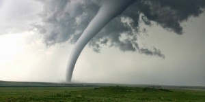
The drill will proceed as follows:
10:00 am: Tornado Watch (drill) given over NOAA Weather Radio. NO SHELTERING REQUIRED.
10:20 am: Tornado Warning (drill) given over NOAA Weather Radio. EVERYONE WILL PROCEED TO DESIGNATED SHELTERS IMMEDIATELY.
10:30 am: All Clear (drill) given over NOAA Weather Radio. EVERYONE RETURN TO WORK STATIONS.
Severe Weather terminology:
Watch: A National Weather Service product indicating that a particular hazard is possible, i.e., that conditions are more favorable than usual for its occurrence. A watch is a recommendation for planning, preparation, and increased awareness (i.e., to be alert for changing weather, listen for further information, and think about what to do if the danger materializes).*
Warning: A product issued by National Weather Service local offices indicating that a particular weather hazard is either imminent or has been reported. A warning indicates the need to take action to protect life and property. The type of hazard is reflected in the type of warning (i.e., tornado warning, blizzard warning, etc.).*
Please make sure you know where your shelter location is prior to this drill. If you are not sure about the workplace or schools procedures you should follow in times of Weather Watches and Warnings, talk to your supervisor. Officials ask you to not take the drill for granted. Use the thirty minutes of this exercise to make sure you know where to go, and the steps to take, when severe weather strikes.


