
118 AM CDT SAT APR 30 2016
EARLY THIS (SATURDAY) MORNING…CLOUDY & BREEZY WITH SCATTERED SHOWERS. LOW IN THE MID 40S. EAST WIND 15 TO 20 MPH WITH GUSTS TO AROUND 30 MPH. CHANCE OF SHOWERS 90 PERCENT.
TODAY…BREEZY. SHOWERS IN THE MORNING. ISOLATED THUNDERSTORMS THROUGH THE DAY. SHOWERS LIKELY IN THE AFTERNOON. HIGH IN THE LOWER 50S. EAST WIND 15 TO 20 MPH WITH GUSTS TO AROUND 30 MPH. CHANCE OF PRECIPITATION NEAR 100 PERCENT.
TONIGHT…SHOWERS LIKELY AND ISOLATED THUNDERSTORMS IN THE EVENING…THEN SHOWERS LIKELY OVERNIGHT. BREEZY. LOW IN THE MID 40S. NORTHEAST WIND 10 TO 20 MPH. GUSTS UP TO 30 MPH THROUGH MIDNIGHT. CHANCE OF PRECIPITATION 70 PERCENT.
SUNDAY...CLOUDY. SHOWERS LIKELY IN THE MORNING…THEN A SLIGHT CHANCE OF SHOWERS IN THE AFTERNOON. HIGH IN THE MID 50S. NORTHEAST WIND 10 TO 15 MPH WITH GUSTS TO AROUND 25 MPH. CHANCE OF SHOWERS 70 PERCENT.
SUNDAY NIGHT…MOSTLY CLOUDY THROUGH MIDNIGHT THEN BECOMING PARTLY CLOUDY. LOW IN THE LOWER 40S. NORTHEAST WIND 5 TO 15 MPH.
MONDAY…PARTLY SUNNY. HIGH IN THE MID 60S.
TUESDAY…MOSTLY SUNNY. HIGH IN THE UPPER 60S.
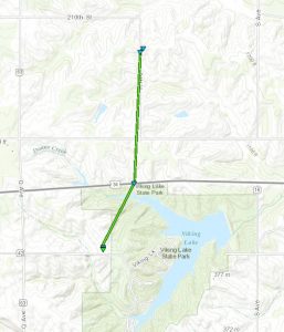
The National Weather Service in Omaha/Valley has confirmed an EF-1 Tornado touched down in rural Montgomery County on Wednesday, April 27th. No injuries were reported and damage was limited.
According to the Weather Service Survey of the event, the twister touched down at 3:14-p.m., three-miles east/southeast of Stanton and ended 5-minutes later three-miles east/northeast of Stanton.
Tornado track
It packed winds of 85-to 90-miles per hour, and was about 25-yards wide. It was on the ground for about one and three-quarters of a mile before dissipating.

Photo of the twister as is crossed Hwy 34 near Viking Lake (Photo credit: Adam Wainwright via the Montgomery County EMA)
Today: Cloudy. A chance of light rain late. High near 58. E/NE @ 10.
Tonight: Showers & thunderstorms, mainly after midnight. Low around 48. E @ 10-20.
Saturday: Showers & occasional thunderstorms. High 58. E @ 15-25.
Sat. Night: A 70% chance of showers. E/NE @ 15-25. Low around 43.
Sunday: Mostly cloudy w/a 40% chance of showers, mainly in the morning. High 58. NE @ 15-25.
Sunday Night: Partly cloudy, with a low around 40.
Monday: P/Cldy. High near 65.
Thursday’s High in Atlantic was 50. Our 24-hour Low thru 7-a.m. today was 42. We received a Trace of precipitation over the 24-hour period, also. Last year on this date, our High in Atlantic was 72 and the low was 34. The All-time Record High in Atlantic on this date was 93 in 1987. The Record Low was 22 in 1958.
346 AM CDT FRI APR 29 2016
EARLY THIS MORNING…CLOUDY. NORTH WIND 5 TO 10 MPH.
TODAY…CLOUDY. HIGH IN THE MID 50S. NORTHEAST WIND 5 TO 15 MPH. GUSTS UP TO 25 MPH IN THE AFTERNOON.
TONIGHT…CLOUDY…BREEZY. A CHANCE OF SHOWERS THROUGH MIDNIGHT…THEN SHOWERS AND ISOLATED THUNDERSTORMS AFTER MIDNIGHT. LOW IN THE MID 40S. EAST WIND 15 TO 20 MPH WITH GUSTS TO AROUND 30 MPH. CHANCE OF PRECIPITATION 80 PERCENT.
SATURDAY…SHOWERS AND ISOLATED THUNDERSTORMS. BREEZY. HIGH IN THE LOWER 50S. EAST WIND 15 TO 20 MPH WITH GUSTS TO AROUND 30 MPH. CHANCE OF PRECIPITATION NEAR 100 PERCENT.
SATURDAY NIGHT…LIGHT SHOWERS LIKELY. BREEZY. LOW IN THE MID 40S. NORTHEAST WIND 15 TO 20 MPH. GUSTS UP TO 30 MPH THROUGH MIDNIGHT. CHANCE OF SHOWERS 70 PERCENT.
SUNDAY…CLOUDY IN THE MORNING THEN BECOMING PARTLY SUNNY. A 40 PERCENT CHANCE OF LIGHT SHOWERS. HIGH IN THE UPPER 50S. NORTHEAST WIND AROUND 15 MPH WITH GUSTS TO AROUND 25 MPH.
MONDAY…MOSTLY SUNNY. HIGH IN THE LOWER 60S.
There are no reports of injuries, but there’s a bit of damage across portions of southern Iowa following a round of severe weather Wednesday. Kevin Skow is a meteorologist with the National Weather Service office in Johnston. “At least three tornadoes we’re aware of, possibly more…generally all confined to southwest Iowa. There was also some small hail with that storm as it moved through southern Iowa,” Skow said.

Stanton Tornado damage 4-27-16 (Photo by Stanton Fire Chief)
The National Weather Service office in Omaha today (Thu.) is sending a storm survey team to an area east of Stanton in Montgomery County. That’s where a tornado damaged an outbuilding and vehicles. Skow says, of the three or so tornadoes, the one near Stanton was probably the most damaging. “They were generally short-lived and generally weak, probably in the neighborhood of EF-0 or EF-1 type damage,” Skow said.
(The Iowa Storm Chasing Network has posted a video of the tornado on the ground near Stanton, on its Facebook page. The link to which is here: https://www.facebook.com/IowaStormChasing/?notif_t=notify_me_page¬if_id=1461699462000718 ) or, on their YouTube page (https://youtu.be/HBf03HDyDG0)
Another tornado passed near Creston in Union County Wednesday afternoon and firefighters reported a brief tornado touchdown with no damage near Hepburn in Page County. Cool and rainy conditions are expected across Iowa through the weekend. “We’re only in April, so these temperatures — highs in the 50s and 60s — are certainly not uncommon this late in the year,” Skow said.
(Radio Iowa)
Today: Mostly cloudy w/a chance of light rain this morning. High 57. N @ 10-20.
Tonight: P/Cldy to Cldy. Low 42. N @ 5.
Tomorrow: P/Cldy to Cldy w/a 20% chance of showers late. High near 60.
Saturday: An 80% chance of Shwrs & tstrms. High 60.
Sunday: Mo. Cldy w/a 40% chance of showers. High 58.
Wednesday’s High in Atlantic was 54. We received .57” of rain over the 24-hour period that ended at 7-a.m. today. The 24-hour Low thru 7-a.m. today was 42. Last year on this date, our High in Atlantic was 75 and the low was 35. The All-time Record High in Atlantic on this date was 94 in 1910. The Record Low was 26 in 1965.
OMAHA, Neb. (AP) – The National Weather Service says a tornado that skipped along a few blocks of northwest Omaha was rated EF1, packing winds of 86 through 110 mph. The service says the tornado stayed on the ground for about eight blocks and seemed to bob up and down after it struck around 3:45 p.m. Wednesday. It toppled a few trees, damaged others and knocked down some fences before dissipating about four minutes later. No injuries have been reported.
Golf ball-size hail fell near Valley and other Douglas County spots. Downpours accompanied the storms that developed Wednesday from the same system that brought rain Tuesday. The service has issued an alert for possible flooding along the Missouri River for Cass and Otoe counties. A flood warning was issued for Nemaha and Richardson counties.
Residents of southwest Iowa saw everything from heavy rain and hail that covered the roadways, to straightline winds and tornadoes that damaged property, but resulted in no injuries that we’re aware of.
In their storm report issued Wednesday night, the National Weather Service says the Stanton Fire Chief saw a tornado four-miles east of Stanton at around 3:15-p.m., that damaged buildings and vehicles at a rural home. Four-miles south of Riverton, in Fremont County, a funnel cloud was seen at around 2:54-p.m.
Stanton Tornado damage 4-27-16 (Photo by Stanton Fire Chief)
A weak, rope-style funnel cloud was reported near Highway 25, 5-miles southeast of Bedford (In Taylor County), at around 5-p.m. About 15-minutes later, damage to a barn was reported to have occurred 2-miles north/northwest of Clearfield.

Large tree branch falls during Wednesday’s storm about 2-miles west of the Hwy 92/71 intersection in Cass County. (Ric Hanson/photo)
At around 5:43-p.m., a tornado was observed 3 miles south/southwest of Creston, near the airport, heading toward Creston. By 5:47-p.m, the twister had become rain-wrapped as it was only about one-mile southwest of town. A few minutes later, law enforcement reported another tornado 3 miles north/northeast of Creston.
Five-miles north of Stanton, flooding was taking place at around 6-p.m., with creeks rising out of their banks. An estimated 4.5-inches had fallen during the day as of 7:45-p.m. Wednesday, with a two-day total of 7-inches of rain.
Heavy rain was also observed in the Griswold area Wednesday afternoon, by KJAN News Director Ric Hanson, who also saw dime-sized hail covering a two-mile stretch of Montgomery County Road H-14, between Highway 48 east to County Road M-63, at around 4:20-p.m. Quarter-size hail was reported 5-miles north of Stanton at around 3:25-p.m.
Quarter-size hail was also reported in Essex at around 3:50-p.m. And, nickel-size hail was observed 5 miles southeast of Bedford, at around 4:35-p.m.
A SMALL STREAM FLOOD ADVISORY CONTINUES UNTIL 9:45-a.m. TODAY (THURSDAY) FOR MONTGOMERY AND NORTHEASTERN PAGE COUNTIES.
DOPPLER RADAR ESTIMATES SHOWED THAT TWO TO FIVE INCHES OF RAIN HAD OCCURRED WEDNESDAY IN THE ADVISORY AREA. A FLASH FLOOD WARNING ISSUED EARLIER WAS ALLOWED TO EXPIRE AT 11-p.m. WEDNESDAY.
SOME LOCATIONS THAT COULD STILL EXPERIENCE FLOODING INCLUDE… RED OAK…CLARINDA…VILLISCA…STANTON…ELLIOTT…GRANT… YORKTOWN… HEPBURN AND VIKING LAKE STATE PARK.


