
Today: P/Cldy to Cldy w/Isolated showers & thunderstorms. High near 80. S/SW @ 10-20. Chance of precipitation is 20%.
Tonight: Cldy w/a 60% chance of showers & thunderstorms, mainly after 11pm. Low around 63. S/SE @ 5-10. New rainfall amounts between three quarters and one inch possible.
Wednesday: Mostly cloudy w/a 50% chance of showers & thunderstorms. High near 80. S/SE @ 10-20. New rainfall amounts between a quarter and half of an inch possible.
Wed. Night: A 40% chance of showers & thunderstorms. Low around 65.
Thursday: P/Cldy w/a 40% chance of showers & thunderstorms. High near 84. S @ 5-10. New rainfall amounts between a tenth and quarter of an inch, except higher amounts possible in thunderstorms.
Thursday Night: A 70% chance of showers & thunderstorms. Low around 64.
Friday: P/Cldy to Cldy w/a 60% chance of shwrs & tstrms. High near 80.
Monday’s High in Atlantic was 77. Our 24-hour Low thru 7-a.m. today was 58. We received .13” of an inch of rainfall early this morning. Last year on this date, our High in Atlantic was 68 and the low was 58. The All-time Record High in Atlantic on this date was 101 in 1939. The Record Low was 33 in 1924.
Today: Mostly cloudy with a 50 percent chance of thunderstorms. High around 80. South wind 5 to 10 mph.
Tonight: Thunderstorms likely. Low in the mid 60s. Southeast wind 5 to 10 mph. Chance of thunderstorms 70 percent.
Wednesday: Mostly cloudy with a 50 percent chance of thunderstorms. High in the mid 80s. South wind 5 to 15 mph with gusts to around 25 mph.
Wednesday Night: Mostly cloudy with a 50 percent chance of thunderstorms. Low in the mid 60s. South wind 5 to 15 mph.
Thursday: Mostly cloudy with a 40 percent chance of thunderstorms. High in the lower 80s.
Thursday Night: Thunderstorms likely. Low in the mid 60s. Chance of thunderstorms 70 percent.
Friday: Thunderstorms likely. High in the upper 70s. Chance of thunderstorms 70 percent.
MILLS IA-POTTAWATTAMIE IA-CASS NE-SARPY NE-
1156 AM CDT MON MAY 23 2016
…SIGNIFICANT WEATHER ADVISORY FOR SOUTHWEST POTTAWATTAMIE…
NORTHWESTERN MILLS…NORTHEASTERN CASS AND EASTERN SARPY COUNTIES UNTIL 1230 PM CDT…
AT 1154 AM CDT…DOPPLER RADAR WAS TRACKING A STRONG THUNDERSTORM NEAR MURRAY…OR 21 MILES SOUTH OF OMAHA…MOVING NORTHEAST AT 30 MPH.
HAIL UP TO NICKEL SIZE AND WINDS IN EXCESS OF 30 MPH WILL BE
POSSIBLE WITH THIS STORM.
LOCATIONS IMPACTED INCLUDE…
SOUTHWESTERN COUNCIL BLUFFS…BELLEVUE…PLATTSMOUTH…PACIFIC JUNCTION…MURRAY…OFFUTT AFB AND CAMP MAHA.
THIS STORM MAY INTENSIFY…SO BE CERTAIN TO MONITOR LOCAL RADIO AND TV STATIONS…AS WELL AS LOCAL CABLE TV OUTLETS…FOR ADDITIONAL INFORMATION AND POSSIBLE WARNINGS FROM THE NATIONAL WEATHER SERVICE.
Forecasters say stormy weather is ahead this week for much of the state along with warmer temperatures and higher humidity levels. Meteorologist Kevin Skow, at the National Weather Service, says some parts of the state were seeing dark clouds already this (Monday) morning.
Skow says, “Today will be just the first of a series of rounds of thunderstorms that will be impacting the state throughout much of the work week.” There’s a chance of severe weather in addition to drenching rains that could bring flash flooding.
“There could be some localized heavy amounts of rainfall,” Skow says. “These storms may be slowly moving at times and total amounts of rainfall could easily be an inch in many locations with localized amounts higher than that.”
After highs across the state last week in the 60s and 70s, this week will be much more summer-like, with highs expected in the 70s and low 80s.
(Radio Iowa)
Today: Mostly cloudy w/a70% chance of showers & thunderstorms. High near 79. S @ 15-25. New rainfall amounts between a quarter and half of an inch possible.
Tonight: Mo. Cldy w/a 50% chance of showers & thunderstorms. Low 62. S @ 5-10 w/gusts to around 20. New rainfall amounts between a quarter and half of an inch possible.
Tuesday: Mo. Cldy w/a 30% chance showers & thunderstorms. High near 79. S @ 10-15. New rainfall amounts between a tenth and quarter of an inch, except higher amounts possible in thunderstorms.
Tuesday Night: A 70% chance of showers & thunderstorms likely, mainly after 8pm. Low around 66.
Wednesday: Mo. Cldy w/showers & thunderstorms, mainly in the morning. High 82. S/SE @ 15-25.
Thursday: Cldy to P/Cldy w/a 40% chance of showers & thunderstorms developing late. High near 79.
Sunday’s High in Atlantic was 79. Our 24-hour Low thru 7-a.m. today was 49. Last year on this date, our High in Atlantic was 66 and the low was 56. The All-time Record High in Atlantic on this date was 97 in 1939. The Record Low was 26 in 1963.
A color-coded rainfall map of Iowa shows the western third of the state in deep purple hues while most of eastern Iowa is multiple shades lighter, in yellow and orange. Jeff Zogg, a hydrologist at the National Weather Service, says parts of water-logged western Iowa have seen 200-percent more rain than average since mid-April, while areas in the much-drier east are only at 50-percent.
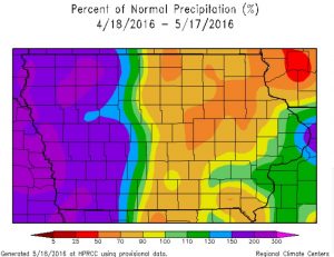 “It’s been much wetter across the western part of the state than the eastern part of the state,” Zogg says. “You get near the Missouri River in western Iowa and rainfall totals over the past month have been twice the normal amount. On the other hand, you get to northeast Iowa, some location have half the normal amounts, so, quite the change across the state.”
While parts of southwest Wisconsin are experiencing near-drought conditions, Zogg does -not- think that’s likely here. “At this point, we’re not expecting drought conditions to materialize across the eastern part of the state,” Zogg says. “We’ve had some persistent wet weather across the western part of the state but we’re seeing an evolution in the weather pattern, especially for the next month or so. It looks like wet weather will be overspreading more of the state. The wetness won’t be confined just to western Iowa.”
Compared to last week, the week ahead is expected to bring big changes in the forecast with warmer temperatures and the likelihood for multiple showers and the potential for heavy rain and severe weather.
(Radio Iowa)
331 AM CDT MON MAY 23 2016
TODAY…MOSTLY CLOUDY. BREEZY. A CHANCE OF THUNDERSTORMS THROUGH MID MORNING…THEN THUNDERSTORMS LIKELY IN THE LATE MORNING AND EARLY AFTERNOON. A CHANCE OF THUNDERSTORMS LATE IN THE AFTERNOON. HIGH IN THE MID 70S. SOUTH WIND 10 TO 20 MPH. CHANCE OF THUNDERSTORMS 70 PERCENT.
TONIGHT…MOSTLY CLOUDY WITH A 50 PERCENT CHANCE OF THUNDERSTORMS. LOW IN THE MID 60S. SOUTH WIND 5 TO 15 MPH.
TUESDAY…MOSTLY CLOUDY. A SLIGHT CHANCE OF THUNDERSTORMS THROUGH MID MORNING. A CHANCE OF THUNDERSTORMS IN THE AFTERNOON. HIGH IN THE UPPER 70S. SOUTH WIND 5 TO 10 MPH. CHANCE OF THUNDERSTORMS 40 PERCENT.
TUESDAY NIGHT…THUNDERSTORMS LIKELY. LOW IN THE MID 60S. SOUTH WIND 5 TO 10 MPH. CHANCE OF THUNDERSTORMS 70 PERCENT.
WEDNESDAY…PARTLY SUNNY WITH A 40 PERCENT CHANCE OF THUNDERSTORMS. BREEZY. HIGH IN THE LOWER 80S. SOUTH WIND 10 TO 20 MPH.
WEDNESDAY NIGHT…MOSTLY CLOUDY WITH A 40 PERCENT CHANCE OF THUNDERSTORMS. LOW IN THE MID 60S.
THURSDAY…MOSTLY CLOUDY WITH A 50 PERCENT CHANCE OF THUNDERSTORMS. HIGH IN THE LOWERS 80S.
Skyscan Forecast for Saturday, May 21, 2016 Richard Garuckas
Today: Mostly Sunny. High 76. E @ 5-10.
Tonight: Partly Cloudy. Low 52. SSE @ 5.
Sunday: Mix of Sun and Clouds. High 80. S @ 10-15 with gusts up to 20.
Sunday Night: Partly Cloudy. Low 59.
Monday: Mostly Cloudy. Moderate chance of Showers and Thunderstorms. High 77.
Tuesday: Partly Sunny. Moderate chance of Showers and Thunderstorms. High 82.
Wednesday: Partly Sunny. Moderate chance of Showers and Thunderstorms. High 84.

Podcast: Play in new window | Download (742.0KB)
Subscribe: RSS
Today: Mostly cloudy w/isolated showers; High near 68. S/SE @ 10-15.
Tonight: Partly cloudy, with a low around 48. SE 5-10mph.
Saturday: Partly cloudy. High near 73. SE @ 5-10.
Sunday: P/Cldy & breezy. High near 78. S/SE @ 10-20 w/gusts to 25.
Sunday Night: A 40 percent chance of showers and thunderstorms developing late. Low around 63. Monday: Showers and thunderstorms likely. Some of the storms could produce heavy rain. High near 74.
Thursday’s High in Atlantic was 69. Our 24-hour Low thru 7-a.m. today was 46. We received .01” (one one-hundredths of an inch) of rainfall early this morning. Last year on this date, our High in Atlantic was 50 and the low was 35. The All-time Record High in Atlantic on this date was 95 in 1925. The Record Low was 26 in 1894.
Today: Isolated showers before 1pm. Mostly cloudy, with a high near 70. South southeast wind 5 to 11 mph. Chance of precipitation is 20%.
Tonight: Partly cloudy, with a low around 49. Southeast wind 3 to 8 mph.
Saturday: Partly sunny, with a high near 74. Light east southeast wind becoming southeast 5 to 10 mph in the morning.
Sunday: Mostly sunny, with a high near 79. Breezy, with a south southeast wind 8 to 17 mph, with gusts as high as 25 mph.
Sunday Night: A 40 percent chance of showers and thunderstorms after 1am. Mostly cloudy, with a low around 63. Breezy. New rainfall amounts between a tenth and quarter of an inch, except higher amounts possible in thunderstorms.
Monday: Showers and thunderstorms likely. Some of the storms could produce heavy rain. Mostly cloudy, with a high near 76. Breezy. Chance of precipitation is 60%.


