
Today: Sunny & breezy. High near 34. West winds @ 10-25 mph. Wind chill values as low as -5.
Tonight: Clear, with a low around 21. W/SW @ 10-20 mph.
Tomorrow: Sunny, with a high near 46. West wind 5 to 10 mph.
Tom. Night: Mostly clear, with a low around 23. W/SW @ 5-10 becoming S/SE.
Monday (Washington’s Birthday): Mostly sunny, with a high near 51.
Monday Night: Partly cloudy, with a low around 24.
Tuesday: Mostly sunny, with a high near 54.
Friday’s High in Atlantic was 30. The Low was 4. We received a Trace of snowfall between 7-a.m. Friday and 7-a.m. today, at KJAN. Last year on this date, the High in Atlantic was 32 and the Low was -9. The Record High for Feb. 17th in Atlantic, was 71 in 2017. The Record Low was -34, in 1958. Sunrise today: 7:13. Sunset: 5:56.
(Radio Iowa) – State Climatologist, Justin Glisan, says Iowa is on pace to have the warmest February on record. “It’s the warmest February to the 16th on record with 152 years of records we’re about 17 degrees above average,” Glisan says. He says the colder temperatures today (Friday) and tomorrow will have some impact, but temperatures are going to warm back up. Glisan says we have two weeks to go before the end of the climatological winter, which he says has been drier than normal.
“Coming off of the third snowiest January on record we’ve really been dry, only three one hundredths of an inch reported statewide as an average so far,” he says. Glisan doesn’t see a lot of change through the end of the month. “This is a function of the strong El Nino that we have set up in the eastern Pacific. warmer ocean waters fire more thunderstorms. Those thunderstorms impact where the jet streams set up over the United States,” Glisan says. So the polar jet is further north. subtropical jet states flatter towards the south metro. We see a lot of precipitation along the Gulf states, and we’re stuck in between so warmer weather and a less active storm track.”
Glisan said early indications is that the warm weather will continue into the first few weeks of March. March 1st begins the three month climatological spring for the northern hemisphere.
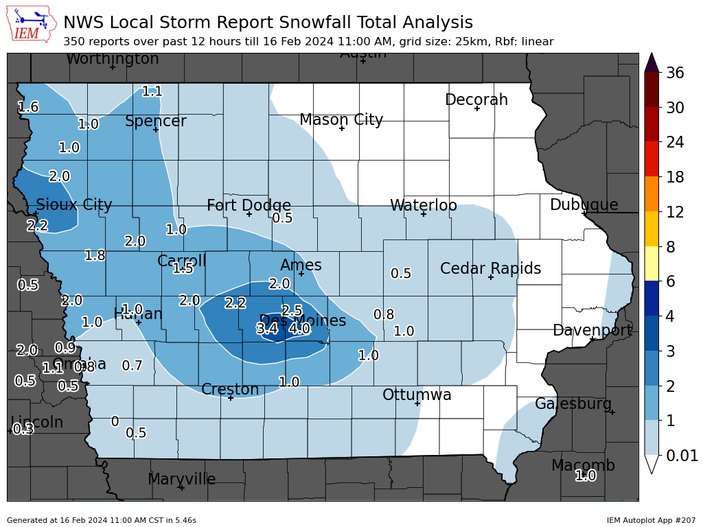
Iowa MesoNet image (11-a.m., 2/16/24)
Today: A 40 percent chance of snow before 8am. Mostly cloudy, with a high near 32. North northeast wind 10 to 15 mph, with gusts as high as 20 mph. New snow accumulation of less than a half inch possible.
Tonight: Mostly cloudy, then gradually becoming clear, with a low around 12. Wind chill values as low as zero. Northwest wind 10 to 14 mph, with gusts as high as 20 mph.
Tomorrow: Sunny, with a high near 37. Wind chill values as low as zero. Breezy, with a west wind 10 to 18 mph, with gusts as high as 24 mph.
Tom. Night: Clear, with a low around 22. West wind 10 to 15 mph, with gusts as high as 23 mph.
Sunday: Sunny, with a high near 48.
Sunday Night: Mostly clear, with a low around 26.
Washington’s Birthday: Mostly sunny, with a high near 53.
Tuesday: Sunny, with a high near 55.
Thursday’s High in Atlantic was 41. The Low was 19. As of 6:50-a.m. (2/16/24) in Atlantic, we had received 1-inch snow, at KJAN. Last year on this date, the High in Atlantic was 23 and the Low was -9. The Record High for Feb. 16th in Atlantic, was 64 in 2017. The Record Low was -33, in 1958. Sunrise today: 7:14. Sunset: 5:54.
The forecast calls for more snow tonight. National Weather Service Meteorologist, Kristy Carter, says it will spread across most of the state.
“It’ll be moving in tonight, for starters in northwest Iowa, but then it will move through the rest of central Iowa into most of Iowa even through the overnight hours, ending tomorrow night in southeast Iowa,” Cart says. She says there will be a band of heavier snow, and it will taper off from there. “Around the Highway 30 to Highway 20 corridors where two to four inches is probably going to be a little more common,” she says. “Elsewhere it’ll be one to two or less than that. If you are close to the band, maybe one to two for areas south and then to far north to northeast it’ll be less than one inch.”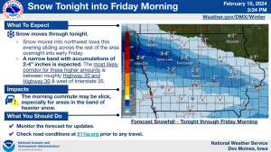
Carter says we won’t have the blowing snow concern that we’ve had with other snowfall. She says the winds will pick up Friday night into Saturday, so they are not concerned about blowing snow. Things will cool off with the snow, but Carter says that won’t last long. She says there will be single digit wind chills Saturday, but the temperatures will move back into the 40s by Sunday. Carter says the snow will melt quickly as the temperatures increase.
Today: Partly to Mostly cloudy skies. High near 40. North wind 5 to 15 mph, with gusts as high as 25 mph.
Tonight: Mo. Cloudy w/a 60% chance of snow after midnight. New Snow accumulation of 1-2 inches is possible. Low around 24. E/NE winds 5-10 mph.
Tomorrow: Mo. Cloudy w/a 30% chance of snow, mainly before 8am. New snow accumulation of less than a half inch possible. High near 32. NE winds at 10-15 becoming N/NW & gusting to near 20 mph.
Tom. Night: Mostly clear, with a low around 13. NW @ 10-20 mph.
Saturday: Sunny & breezy, with a high near 38.
Sat. Night: Clear & breezy, with a low around 21.
Sunday: Sunny, with a high near 47.
Wednesday’s High in Atlantic was 59. The Low was 20. Last year on this date, the High in Atlantic was 30 and the Low was 18. The Record High for Feb. 15th in Atlantic, was 72 in 1921. The Record Low was -31, in 1905. Sunrise today: 7:15. Sunset: 5:53.
Today: Partly cloudy to cloudy & breezy. High near 55. S/SE winds 5-15 mph w/gusts to around 25 mph.
Tonight: Mostly cloudy & blustery w/a slight chance of rain before midnight. Low around 27. SE-N @ 10-30 mph.
Tomorrow: Mostly sunny, with a high near 40. North wind 10-20 mph.
Tom. Night: A 50 percent chance of snow, mainly after midnight. Low around 23. New snow accumulation of less than a half inch possible.
Friday: A 40 percent chance of snow, mainly before noon. High near 33.
Saturday: Sunny & breezy, with a high near 35.
Tuesday’s High in Atlantic was 54. The Low was 21. Last year on this date, the High in Atlantic was 47 and the Low was 27. The Record High for Feb. 14th in Atlantic, was 68 in 1934. The Record Low was -20, in 1936. Sunrise today: 7:17. Sunset: 5:52.
Today: Partly sunny, with a high near 50. Winds E/SE @ 5-10 mph.
Tonight: Mostly clear, with a low around 28. E/NE @ around 5 mph becoming S/SE after midnight.
Wednesday: Increasing clouds, with a high near 54. Southeast wind 5 to 10 mph.
Wed. Night: Mo. Cldy & blustery w/a 40% chance of rain. Low 27. E/SE @10-25.New precipitation amounts between a tenth and quarter of an inch possible.
Thursday: Mostly sunny, with a high near 41. N/NW @ 5-15 w/gusts to near 25.
Thursday Night: A 30% chance of snow, mainly after midnight. Low around 23.
Friday: A 40% chance of snow, mainly before noon; Partly sunny & blustery. High near 31.
Monday’s High in Atlantic was 52. The Low was 19. Last year on this date, the High in Atlantic was 56 and the Low was 21. The Record High for Feb. 13th in Atlantic, was 63 in 1934. The Record Low was -30, in 1905. Sunrise today: 7:18. Sunset: 5:51.
Today: Sunny, with a high near 46. W/SW winds becoming NW @ 5-10.
Tonight: Increasing clouds, with a low around 28.
Tomorrow: Partly sunny, with a high near 48. South wind 5-10 mph.
Wednesday: Partly sunny, with a high near 53.
Wed. Night: A 40% chance of rain before midnight. Mostly cloudy & windy. Low around 26.
Thursday: Mostly sunny & windy, with a high near 40.
Sunday’s High in Atlantic was 40. The Low was 17. Last year on this date, the High in Atlantic was 49 and the Low was 20. The Record High for Feb. 12th in Atlantic, was 72 in 1990. The Record Low was -24, in 1986 & 1988. Sunrise today: 7:20. Sunset: 5:50.
Today: Mostly cloudy, then gradually becoming sunny, with a high near 44. Northwest wind 3 to 8 mph.
Tonight: Clear, with a low around 26. West northwest wind around 5 mph becoming light and variable.
Monday: Sunny, with a high near 48. West wind 5 to 10 mph becoming north northwest in the afternoon.
Monday Night: Mostly cloudy, with a low around 27. North northwest wind around 6 mph becoming calm after midnight.
Tuesday: Partly sunny, with a high near 50. South wind 5 to 10 mph.
Tuesday Night: Partly cloudy, with a low around 28.
Wednesday: Mostly sunny, with a high near 48.
Saturday’s High in Atlantic was 41. The Low was 20. Last year on this date, the High in Atlantic was 47 and the Low was 25. The Record High for Feb. 11th in Atlantic, was 64 in 1951 & 1999. The Record Low was -26, in 1899. Sunrise today: 7:20. Sunset: 5:48.


