
Today: Areas of fog before 9am. Otherwise, sunny, with a high near 70. Light southwest wind becoming south southwest 9 to 14 mph in the morning. Winds could gust as high as 18 mph.
Tonight: Mostly clear, with a low around 38. South southwest wind around 9 mph.
Wednesday: Sunny, with a high near 72. South southwest wind 8 to 13 mph becoming west northwest in the afternoon. Winds could gust as high as 21 mph.
Thursday: A 50 percent chance of rain after noon. Mostly cloudy, with a high near 49. Breezy. New precipitation amounts of less than a tenth of an inch possible.
Thursday Night: Rain before 4am, then rain and snow likely. Some thunder is also possible. Low around 33. Breezy. Chance of precipitation is 90%.
Friday: Rain and snow, becoming all snow after 2pm. High near 36. Windy. Chance of precipitation is 80%.
Monday’s High in Atlantic was 60 degrees, which fell short of the record by just 5 degrees. We received .18” of an inch of rain Monday, for a storm total of .43.” Our low this morning was 29. Last year on this date, our High in Atlantic was 44 and the low was 31. The Record High in Atlantic on this date was 65 in 1977. The Record Low was -19 in 1894.
Officials with the Shelby County Emergency Management Agency say Local Fire Danger Assessments for this spring season have begun, as a result of several, recently experienced grass and brush fires. EMA Coordinator Bob Seivert says with the record breaking and unseasonably high heat , dead vegetation is extremely flammable. The National Weather service is issuing Fire weather watches for tomorrow (Tuesday) for parts of southeast Nebraska.
 Seivert says one change you should be aware of, is that when conditions rapidly change to the very highest category and or the NWS issues a Red Flag Warning, the Shelby County EMA will immediately change the local Fire Danger Boards to Extreme and all burning will be prohibited, unless prior arrangements are made with the local Fire Chief and a burn plan is completed and filed. Fire departments will be notified via “I am responding.”
Seivert says even with the snow in the forecast, once it is gone, drying occurs much more rapidly than most people realize. Their goal, he says is to reduce unnecessary emergency response, by elevating the public’s awareness of conditions favorable to burning, and offering burn plan assistance, for any size burn. The cooperative initiative between the local fire Departments, their Chiefs, and Emergency Management in Shelby County has proven effective in every aspect.
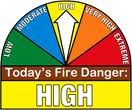
Participating businesses and fire stations should place their Local Fire Danger Signs in the HIGH Category until the next update on Thursday, Feb. 23rd.
As a reminder: The High Fire Danger Category means Burning of any kind is restricted unless approval is received from local Fire Chief. Controlled burns that are not reported will result in Fire Department being dispatched, and Fires extinguished if determined to be un-safe. Call 712-755-2124 if you have any questions.
(Updated 4:45-a.m.)
Today (Washington’s Birthday): Cloudy w/Showers & thunderstorms High 67. S winds 10-20 becoming westerly this afternoon.
Tonight: Showers and light rain ending early. Becoming P/Cldy. Low 34. W @ 10.
Tuesday: Sunny. High near 70. W @10-15 w/gusts to near 25.
Wednesday: P/Cldy. High near 70.
Thursday: Mo. Cldy w/a chance of light rain. High near 47.
Sunday’s High in Atlantic of 71 degrees broke the record High of 66 set in 1930. We received .25” of an inch of rain overnight until 7-a.m. today. Our 24-hour Low ending today at 7-a.m., was 32. Last year on this date, our High in Atlantic was 53 and the low was 29. The Record High in Atlantic on this date was 65 in 1925. The Record Low was -19 in 1978.
Today: Mostly sunny & breezy. High near 71. Winds becoming S @ 15-25.
Tonight: Mostly cloudy w/a 60% chance of scattered showers & thunderstorms. Low around 55. South wind around 10-15 mph. New rainfall amounts of less than a tenth of an inch, except higher amounts possible in thunderstorms.
Monday (Washington’s Birthday): Cloudy & breezy w/a 60% chance showers & possibly a thunderstorm. High near 67. S @ 10-20 w/gusts to 25. New rainfall amounts between a tenth and quarter of an inch, except higher amounts possible in thunderstorms.
Monday Night: Partly cloudy, with a low around 40. West wind 7 to 9 mph.
Tuesday: Sunny, with a high near 73. Southwest wind 7 to 14 mph.
Wednesday: Mostly sunny, with a high near 69
Today: Mostly sunny. High 63. N @ 5-10.
Tonight: Partly cloudy. Low 37. E/SE @ 5-10.
Tomorrow: Mostly cloudy. High 71. S/SE @ 10-15.
Sunday night: Cloudy w/a 50% chance of rain. Low around 53.
Monday: Mo. Cldy w/a 60% chance of rain. High 64.
Tuesday: Mostly sunny. High 67.
Wednesday: Partly Sunny. High 69.
Friday’s High in Atlantic of 71 degrees broke the record High of 67 set in 1981. Our Low this morning ending at 7-a.m. (24-hour Low) was 25. Last year on this date, our High in Atlantic was 62 and the low was 35. The Record High in Atlantic on this date was 66 in 1930. The Record Low was -25 in 1978.
Monona-Harrison-Shelby-Pottawattamie-Mills-Montgomery-Fremont-
Page Counties:
Unseasonably warm temperatures and dry conditions will result in elevated fire weather concern today across much of the area. Relative humidity this afternoon will fall to around 20 percent in southeast Nebraska and southwest Iowa with southwest winds 10 to 20 mph. A cold front will move into northeast Nebraska during the afternoon with humidity there between 25 and 30 percent and northwest winds 10 to 20 mph.
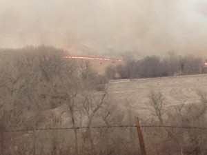
File photo (area field fire March 2014)
Outdoor burning is discouraged due to the increased fire danger today. Use extra caution if using motorized vehicles in grassy areas and handle the disposal of smoking material with care.
Today: Partly cloudy. High 72. SW @ 10-20.
Tonight: P/Cldy. Low 34. NW @ 5.
Tomorrow: P/Cldy. High 63. Winds variable @ 5-10.
Sunday: P/Cldy to cldy. High around 65.
Monday: Mo. Cldy w/light rain. High near 60.
Thursday’s High in Atlantic of 64 degrees broke the record High of 62 set in 1921 & 1961. Our 24-hour Low was 29. Last year on this date, our High in Atlantic was 41 and the low was 29. The Record High in Atlantic on this date was 67 in 1981. The Record Low was -34 in 1958.
Today: Partly cloudy. High 63. SW @ 10-20.
Tonight: P/Cldy. Low 36. SW @ 5-10.
Tomorrow: P/Cldy. High near 70. SW @ 10-20.
Saturday: P/Cldy. High around 60.
Sunday: P/Cldy to Cldy. High near 60.
Wednesday’s High in Atlantic was 47. Our Low was 25. Last year on this date, our High in Atlantic was 34 and the low was 29. The Record High in Atlantic on this date was 62 in 1921 & 1961. The Record Low was -33 in 1958.
Today: Partly cloudy. High 50. NW-W @ 10-15.
Tonight: Fair to P/Cldy. Low 30. SW @ 5-10.
Tomorrow: P/Cldy. High 63. SW @ 10-20.
Friday: P/Cldy. High 68.
Saturday: P/Cldy. High near 60.
Tuesday’s High in Atlantic was 49. Our Low this morning was 25. Last year on this date, our High in Atlantic was 45 and the low was 28. The Record High in Atlantic on this date was 72 in 1921. The Record Low was -31 in 1905.
Today: Partly cloudy. High 48. NW @ 10-20.
Tonight: Mostly clear. Low 21.
Tomorrow: Mostly Sunny. High 48. W @ 10.
Thursday: P/Cldy. High near 60.
Friday: P/Cldy. High 65.
Monday’s High in Atlantic was 49. Our Low this morning was 23.Last year on this date, our High in Atlantic was 31 and the low was 17. The Record High in Atlantic on this date was 68 in 1934. The Record Low was -20 in 1936.


