
Today: Partly sunny w/just a slight chance of showers & thunderstorms this afternoon. High near 70. West wind 5 to 15 mph becoming east in the afternoon.
Tonight: Showers and thunderstorms likely. Low around 52. E winds @ 15-25.
Tomorrow: Showers and thunderstorms. High near 66. E/SE winds 15-25 shifting to the West Thursday afternoon.
Tom. A chance of showers and thunderstorms, otherwise P/Cldy. Low around 42.
Friday: Sunny, with a high near 71.
Saturday: A 40% chance of showers and thunderstorms before 1pm; Partly sunny, with a high near 66.
Tuesday’s High in Atlantic was 75. Our Low this morning, 43. We received just .08″ rain Tuesday. Last year on this date, the High in Atlantic was 64 and the Low was 35. The All-time Record High on May 1st was 90, in 1965. The Record Low was 24, in 1909. Sunrise: 6:17; Sunset: 8:17.
(Des Moines, Iowa) – The National Weather Service office in Des Moines, in it’s latest update on Monday, said based on preliminary reports and completed storm surveys, severe storms that lifted northeast across western into central Iowa late in the afternoon into the evening of Friday, April 26, 2024, numbered at least 19. Damage to trees and homes has been reported in multiple counties from Crawford to Union and Ringgold up to around Polk and Jasper Counties.
Teams continue to evaluate damage. Additional tornado tracks and rating will be added in the coming days. A final tornado count will take days to a few weeks as we review radar data, examine hi-res satellite imagery, and look at videos.
Learn about the other tornadoes covered by the NWS office in Des Moines, HERE.
Today: Showers and thunderstorms likely, mainly after 5pm. High near 79. Southerly winds @ 20-40 mph this afternoon. New rainfall amounts between a tenth and quarter of an inch, except higher amounts possible in thunderstorms. Some of the storms will likely be strong to severe and capable of producing large hail and damaging winds. A few tornadoes are possible as well.
Tonight: Showers and thunderstorms ending, then gradual clearing, with a low around 46. W/SW @ 15-30 mph. New precipitation amounts of less than a tenth of an inch, except higher amounts possible in thunderstorms.
Wednesday: Partly sunny w/a 50% chance of showers and thunderstorms. High near 70. S/SE @ 10-20.
Wed. Night: Showers and possibly a thunderstorm. Low around 52.
Thursday: Showers and possibly a thunderstorm. High near 72.
Friday: A 20 percent chance of showers. Mostly sunny, with a high near 69.
Monday’s High in Atlantic was 66. Our Low this morning, 43. Last year on this date, the High in Atlantic was 63 and the Low was 37. The All-time Record High on April 30th was 92, in 1926. The Record Low was 19, in 1958. Sunrise: 6:19; Sunset: 8:16.
(Omaha, NE) – The National Weather Service in Omaha has released a preliminary report on the storms that passed through eastern Nebraska and parts of western Iowa on April 26th. Officials broke down the data as follows:
(Radio Iowa) – Weather experts say at least 17 tornadoes touched down in Iowa Friday afternoon and evening, including perhaps a half-dozen that are classified as E-F-2s, with winds up to 135 miles an hour. Meteorologist Craig Cogil, at the National Weather Service, says it may be several days before they have a complete tornado tally. Multiple teams are evaluating the damage, which Cogil says includes in-person surveys, as well as reviewing the radar data, satellite imagery, and videos. “These bigger outbreaks do take time to go through and find out all the tracks across the state,” Cogil says. “It’s likely we’ll see a few more added on here before we have the final total for the system. We may get up towards 20 across the state, but right now, we can confirm about 17 across the state.”
The Omaha office issued 42 tornado warnings on Friday for its region of Nebraska and Iowa, while Cogil says the Johnston office issued perhaps another two dozen for western and central Iowa. He says they’re trained to handle such tense situations where seconds can mean a tremendous difference to anyone who may be in harm’s way. “These are the ones that are the most life-threatening and can potentially do the most harm,” Cogil says. “They do stress us quite a bit when we have to go through an event like that, but overall, the thing is, we’re just really trying to get the word out so people can take the appropriate action, and potentially life-saving action.”
There have been situations in recent years where National Weather Service staffers in Iowa had to leave their posts because tornadoes were heading directly for them. “In instances like that in particular, you don’t really want to stop or quit doing what you’re doing but at the same time, you need to take shelter if there’s something that is heading towards the office,” Cogil says. “Fortunately, we have several offices around that can back us up and continue to issue warnings if we do have to take cover. It’s part of the job.”
Friday’s severe weather marks the second tornado outbreak in Iowa this month. On April 16th, there were 13 tornadoes that touched down in the state, so we’ve had roughly 30 twisters so far. Cogil says there’s no way to know what’s coming in the rest of the tornado season ahead. “We do have some years that start out really quickly, and then eventually, it tapers off as you head into May and June,” Cogil says, “but there’s other ones where it starts hot and heavy and it just stays that way through June or July. Every year is a little bit different and we just have to be prepared for what Mother Nature throws at us.”
He cautions, tornadoes can strike any time of the day or night and during any month of the year.
Today: Mostly cloudy, then gradually becoming sunny, with a high near 66. West wind 10 around 20 mph.
Tonight: Mostly clear, with a low around 45.
Tuesday: Mostly sunny & windy, w/a 70% chance of late afternoon showers & thunderstorms. High near 78. S @ 15-30 mph.
Tue. Night: Showers and thunderstorms through midnight, then partly cloudy. Low 45.
Wednesday: P/sunny w/a 70% chance of afternoon showers & thunderstorms. High near 69.
Thursday: Showers and thunderstorms. High near 72.
Sunday’s High in Atlantic was 67. Our Low this morning, 46. We received .29″ rain Sunday into early today. Last year on this date, the High in Atlantic was 63 and the Low was 36. The All-time Record High on April 29th was 93, in 1987. The Record Low was 22, in 1958. Sunrise: 6:20; Sunset: 8:15.
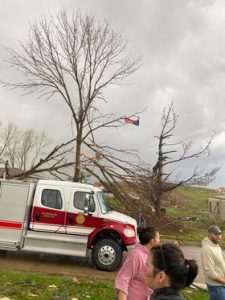
Pottawattamie County, Iowa– A state of emergency remains in effect for Pottawattamie County and in the City of Minden, following severe weather that occurred on Friday, April 26th, when several confirmed tornado activity in the areas. Affected areas include western portions of Council Bluffs, northeast of Crescent, east of McClelland, southwest of Treynor, and the city of Minden. In total, the NWS Omaha issued 42 tornado warnings for its coverage area, which includes parts of western Iowa.
Iowa Governor Kim Reynolds issued a proclamation of disaster emergency for Pottawattamie County Friday night. Officials think about half the town of Minden – with a population of about 600 – was destroyed. Four storm-related injuries have been reported. Three individuals were treated and released, while one remains hospitalized in stable condition. Saturday morning, the city opened for residents to be able to start their cleanup and recovery.
“We signed a disaster proclamation last night, which opened up state resources and individual assistance for the community,” Reynolds said Saturday. She said emergency responders are on the ground and were working to remove debris. She said “then we’ll just assess what we need to do next, what next steps are.”
Minden’s mayor broke down in tears at one point during the governor’s tour of the damage. The Mayor sustained damage to his home and business in 1976 and now in 2024. Community members are hopeful that they will recover. A curfew of 10-p.m. until 6-a.m. remains in until further notice for the City of Minden.
Preliminary information indicates varying degrees of damage to approximately 120 homes and businesses in Pottawattamie County. American Red Cross established two shelters in the county that were not needed as displaced residents were able to arrange overnight accommodations, according to the Pott. County EMA.
The most concentrated damage from these weather events occurred in Minden. Gas and power utilities services have been disrupted, and access to the city of Minden has been closed to outside traffic. Due to the hazardous conditions, only residents of Minden will be granted access at this time.
Ongoing disaster information can be found on Emergency Management Agency website at https://pcema-ia.org. Community-specific information for Minden can be found on the City of Minden Facebook page, as well as the Tri-Center Community School District Facebook page. Damage to residential and business properties should be reported at the Emergency Management Agency website.
The NWS office in Des Moines says, based on preliminary reports, at least 10 tornadoes occurred in their central/southern Iowa warning area of responsibility. Damage to trees and homes has been reported in multiple counties from Crawford to Union and Ringgold up to around Polk and Jasper Counties. Teams continue to evaluate damage.
Twisters in the Creston and Afton areas were rated as EF-2’s, with with speeds estimated at between 125-130 mph, and were on the ground anywhere from 6-10 miles. They ranged from 150 to 350 yards wide. A tornado near Mount Ayr was rated an EF-1, with winds of up to 110-mph. It was on the ground for 26.5 miles, and was 300 yards wide.
Today: Showers and thunderstorms. Some severe weather is possible this afternoon & evening. High near 69. East wind 10 to 15 mph becoming south southwest in the afternoon. Winds could gust as high as 20 mph. New rainfall amounts between a quarter and half of an inch possible.
Tonight: A chance of showers and thunderstorms ending late. Low around 42. West winds 10-20 mph.New precipitation amounts of less than a tenth of an inch, except higher amounts possible in thunderstorms.
Monday: Partly sunny, with a high near 65. West wind 15 to 25 mph mph.
Monday Night: Mostly clear, with a low around 47.
Tuesday: Mostly sunny in the morning; Showers & or thunderstorms possible during the afternoon. Some severe storms are possible. High near 78.
Tuesday Night: Showers and thunderstorms likely, otherwise partly cloudy, with a low around 47.
Wednesday: Partly sunny w/a chance of showers and thunderstorms, especially during the afternoon. High near 71.
Saturday’s High in Atlantic was 63. Our Low this morning was 52. We received .32″ of rain in Atlantic Saturday. Last year on this date, the High in Atlantic was 62, and the Low was 34. The All-Time Record High on April 28th in Atlantic, was 94, in 1910. The Record Low was 26, in 1965. Sunrise: 6:21. Sunset: 8:14.
**Massena reports .3″ rain from 7-a.m. Saturday through 7-a.m. today**
Pottawattamie County, Iowa– On April 26 th , Pottawattamie County experienced severe weather, with confirmed
tornado activity in several areas. Affected areas include western portions of Council Bluffs, northeast of Crescent, east
of McClelland, southwest of Treynor, and the city of Minden.
The City of Minden has declared a state of emergency. Pottawattamie County has declared a state of emergency, and
Iowa Governor Kim Reynolds has issued a proclamation of disaster emergency for Pottawattamie County.
At the time of this release, four storm-related injuries have been reported. Three individuals were treated and
released, while one remains hospitalized in stable condition.
Preliminary information indicates varying degrees of damage to approximately 120 homes and businesses in Pottawattamie County. American Red Cross established two shelters in the county that were not needed as displaced residents were able to arrange overnight accommodations.

Photos of Minden, courtesy of Zach Ploen.


Pott. County EMA
The most concentrated damage from these weather events occurred in Minden. Gas and power utilities services have
been disrupted, and access to the city of Minden has been closed to outside traffic. A curfew has been issued for the
city of Minden between 10:00PM and 6:00AM and will remain in effect until further notice.
Beginning at 8:00AM on April 27 th , impacted residents seeking a return to Minden will be allowed admission. The
check-in location for admission will be at the Minden United Church of Christ at 106 Lincoln Street. Due to the
hazardous conditions, only residents of Minden will be granted access at this time. Officials are not currently seeking
outside volunteer assistance but will announce those opportunities in the coming days.
Ongoing disaster information can be found on Emergency Management Agency website at https://pcema-ia.org.
Community-specific information for Minden can be found on the City of Minden Facebook page, as well as the Tri-
Center Community School District Facebook page.
Damage to residential and business properties should be reported at the Emergency Management Agency website.


