
Today: Showers and thunderstorms, mainly before 9am. Some of the storms could produce heavy rainfall. High near 62. Breezy, with a west wind 15 to 20 mph becoming north northwesterly & gust as high as 25 mph. New precipitation amounts between a tenth and quarter of an inch, except higher amounts possible in thunderstorms.
Tonight: Mostly clear, with a low around 41.
Sunday: Sunny, with a high near 66. E/SE winds 5-10.
Sunday Night: Partly cloudy, with a low around 48.
Monday: A 50% chance of showers & thunderstorms. High near 74.
Monday Night: Showers & thunderstorms. Low around 51.
Tuesday: A slight of chance of showers and thunderstorms, otherwise sunny & breezy, with a high near 74.
Friday’s High temperature in Atlantic was 71. The Low was 37. We received .56″ rain ( 7-a.m. Friday thru 7a.m. today), in Atlantic. Last year on this date, the High was 82 and the Low was 36. The Record High set on May 4th in Atlantic was 91 in 1918. The Record Low was 18 in 1907. Sunrise: 6:14. Sunset: 8:21.
(Des Moines, Iowa; via the Iowa Capital Dispatch) – Drought conditions in the state continue to retreat amid abundant rainfall, according to the U.S. Drought Monitor. A Thursday report shows the biggest moisture gains in western and southern Iowa. Less than half of the state now has drought for the first time since June 2023. That’s down from about 96% of the state in October.
Last week’s statewide precipitation averaged 1.32 inches, according to the U.S. Department of Agriculture. That’s about 45% more than is normally expected. The highest reported rainfall was 4.72 inches in Little Sioux in far western Iowa, whereas the least was one-tenth of an inch near Guttenberg in far northeast Iowa.
A wide area of severe drought remains in eastern Iowa, although it has been shrinking. Much of that area had previously suffered from extreme drought — the second-to-worst classification issued by the Drought Monitor — but its presence has greatly diminished. About 2% of the state has extreme drought, down from 35% at the start of the year.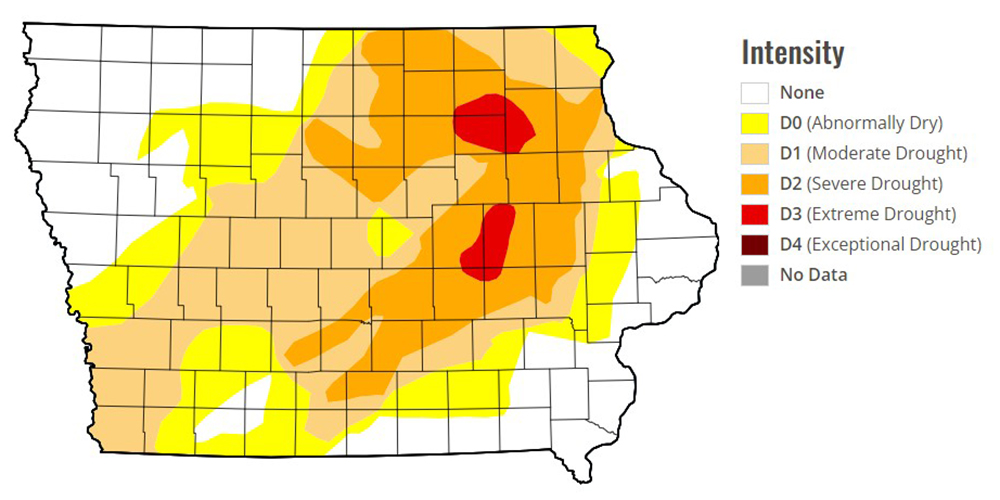
Drought conditions might lift from about a quarter of the state in the coming months, according to a recent report by the U.S. Climate Prediction Center. Drought is expected to remain, but improve, in the worst-affected areas. A USDA report on Monday said about 78% of cropland has adequate or surplus soil moisture, which is slightly better than a year ago.
Crop planting has been several days ahead of the five-year average. As of Sunday, about 39% of corn and 25% of soybeans had been planted.
Today: Areas of fog before 8am. Otherwise, mostly sunny, with a high near 71. SE/S-SE winds @ 10-20.
Tonight: Showers likely and possibly a thunderstorm developing late. Low around 48. SE @ 10-20.
Tomorrow: Showers & possible thunderstorms; Gradually becoming mostly sunny. High near 64. N @ 15-25.
Tom. Night: Mostly clear, with a low around 41.
Sunday: Mostly sunny w/only a 20% chance of showers after 1pm. High near 69.
Sunday Night: A slight chance of showers & thunderstorms. Low around 52.
Monday: Windy w/a 70% chance of showers & thunderstorms. High near 75.
Thursday’s High temperature in Atlantic was 62. Our Low this morning was 37. We received .04″ rain Thursday (after 7-a.m.), in Atlantic. Last year on this date, the High was 73 and the Low was 29. The Record High set on May 3rd in Atlantic was 87 in 1895, 1949 & 1968. The Record Low was 25 in 1900. Sunrise: 6:14. Sunset: 8:19.
DES MOINES – Governor Kim Reynolds has requested an expedited Presidential Disaster Declaration for nine Iowa counties where significant damage was sustained from severe weather that occurred on April 26, 2024. The governor requested funding under the Federal Emergency Management Agency’s (FEMA) Individual Assistance Program and the activation of the U.S. Small Business Administration (SBA) Disaster Loan Program for Clarke, Crawford, Harrison, Mills, Polk, Pottawattamie, Ringgold, Shelby, and Union Counties.
Funding under the Federal Emergency Management Agency’s (FEMA) Individual Assistance Program provides disaster-affected homeowners, renters, and businesses access to programs and services to maximize recovery, including assistance with housing, personal property replacement, medical expenses, and legal services. 
The U.S. Small Business Administration (SBA) Disaster Loan Program provides homeowners, renters, businesses, and most nonprofit organizations in the affected counties whose property was damaged or destroyed by this disaster, the ability to apply for low-interest disaster loans from the SBA. In addition, the governor requested funding to conduct hazard mitigation activities for the entire state.
‘The letter can be read in its entirety here.
(Radio Iowa) – State Climatologist Justin Glisan says April brought the showers the state needs. “We’re actually about eight-tenths of an inch above average and particularly wet across southeastern Iowa and northwestern Iowa, where we’ve seen drought removal and drought improvement,” Glisan says. April was also warmer than normal. “Two degrees above the normal average that we would expect for April,” he says. The April average temperature is around 48 degrees. Glisan says the storms that brought the rain also gave us some severe weather. “Almost 40 tornadoes reported across the state and that’s approaching the April record,” he says.
Glisan says the immediate outlook for this month shows the same trends as April. “We’re trending towards warmer to near normal temperatures, but we’re also seeing a wetter signal for the first two weeks of May,” Glisan says. “And May being the second wettest month of the year for Iowa climatologically, we could expect a lot of thunderstorm potential, and a lot of rainfall potential across the state.” Glisan says the rain is welcome to combat the drought, but farmers also need a little dry time to plant. “We do need to get planted, we do need to get that field work completed, and we’ve been wet over the last two weeks,” he says.
Corn and soybean planting were slightly ahead of schedule heading into this week.
Today: Showers and thunderstorms, mainly before 11am. High near 69. East southeast wind 10 to 15 mph becoming west northwest in the afternoon. Winds could gust as high as 20 mph.
Tonight: Partly cloudy, with a low around 43.
Friday: Sunny, with a high near 72. Light east wind becoming southeast 5 to 10 mph in the morning.
Friday Night: A slight chance of showers and thunderstorms developing late. Low around 48.
Saturday: A chance of showers and thunderstorms, otherwise Partly sunny, with a high near 66.
Sunday: Mostly sunny w/a slight chance of showers during the afternoon. High near 70.
Monday: P/Sunny & windy, w/a 60% chance of showers and/or thunderstorm during the afternoon. High near 76.
Wednesday’s High in Atlantic was 66. Our Low was 45. 24-hour Rainfall at KJAN (ending at 7-a.m. today), was .78.” Last year on this date, the High in Atlantic was 66 and the Low was 27. The All-time Record High on May 2nd was 91, in 1968. The Record Low was 17, in 1908. Sunrise: 6:15; Sunset: 8:18.
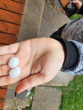
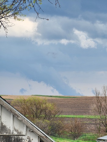
A KJAN listener sent us photo of a tornado on the ground and hail that fell, Tuesday evening, near Elliott. Thank you!
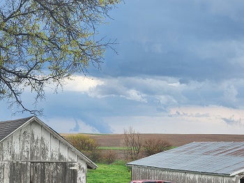
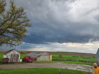
(Atlantic, Iowa – KJAN) – Weather data for the month of April, 2024, in Atlantic, shows we were slightly warmer and drier than average. The Average High last month was 66 (4 degrees warmer than average), while the average Low was 37 (which was typical for April ). Precipitation amounted to 2.53 inches last month, which was nine-tenths (.9″) of an inch below the norm. The data was compiled at KJAN, the official National Weather Serving reporting site for Atlantic.
Looking ahead, we find the Average High for the month of May in Atlantic, is typically 73 degrees, while the Low should average out to be around 49. Precipitation is typically amounts to 4.32 inches.
The National Weather Service in Des Moines reports several locations in southwest Iowa were hit by severe storms that caused some damage, Tuesday. In the KJAN listening area, egg-size hail (2 inches in diameter) was reported six-miles southwest of Massena in CASS COUNTY at around 4:37-p.m. Other hail reports show Quarter-size hail (1″ in diameter) fell near in or near Orient and Cromwell, while hail the size of pennies fell in Corning, lasting about 20-minutes, and causing some minor tree damage.
Other reports:
Large hail was reported from Council Bluffs to Indianola, as well as north of the metro from Carroll to Ames. One confirmed tornado was reported near Millerton, south of Chariton.