
(Radio Iowa) – We’re just past the halfway point for Iowa’s tornado season, and while twisters can strike during any month of the year, April, May and June are considered the three prime months for tornadic activity. Meteorologist Mike Fowle, at the National Weather Service in Johnston, says it’s been a very active season so far. “Our preliminary numbers suggest we have seen 43 tornadoes,” Fowle says. “Interestingly enough, all of those have occurred in the month of April. We are still investigating some reports back from our previous events, say from April 26th, we’re still investigating so it’s possible we could still add a tornado or two from some of these events.” While the tornado tally doesn’t set an Iowa record, Fowle says it -is- an impressive number.
“For 43 tornadoes for a month, that’s pretty darn high,” Fowle says. “We go back generally to about 1950 and forward as our more accurate trend of record, so that would have been the fourth highest number of tornadoes we’ve seen in any month, the highest being May of 2004 with 57.” We do live in tornado alley and some years they’re plentiful, while we’re spared in others. “In 2023, we had a total for the whole year in the state of Iowa of 72, while in 2022, we only had 42 for the entire year, so we obviously surpassed that in one month this year,” Fowle says, “and then if we go back even just one more year to 2021, we had a total of 114 tornadoes.”
The bulk of the 2021 tornadoes occurred on December 15th of that year, in a highly unusual late year outbreak. There were 63 tornadoes in Iowa that day, along with the first-ever December derecho anywhere in the U-S.
Today: Mostly cloudy with isolated showers and thunderstorms. High near 80. Southwest wind 5 to 10 mph.
Tonight: A 50% chance of showers and thunderstorms late. Some of the storms could produce heavy rainfall. Low 61.
Tuesday: Showers & possible thunderstorms. Some of the storms could produce heavy rainfall. High near 80. SE @ 15-35 mph.
Tue. Night: A slight chance of showers and thunderstorms. Low around 49.
Wednesday: Mostly sunny, with a high near 71.
Thursday: Mostly sunny, with a high near 76.
Sunday’s High in Atlantic was 71. The Low was 56. We received .26″ rain at KJAN, Sunday. Last year on this date, the High in Atlantic was 73 and the Low was 37. The Record High for May 20th was 95 in 1925. The Record Low was 26 in 1894. Sunrise: 5:56. Sunset: 8:36.
(Massena, Iowa) – Volunteer Firefighter Levi Lank captured video of a tornado located three-miles southwest of Massena off of Victoria Road, this (Sunday) evening. The twister touched down at around 7:58-p.m. There were no reports of damage or injuries. (Still frame images from the video, Photo credit: Levi Lank). While the National Weather Service had issued a Severe Thunderstorm Warning for southeastern Cass and southwestern Adair Counties just before 8-p.m., there was NO TORNADO WARNING issued. The Cass County Communications Center set-off the sirens in Cumberland and Massena when spotters observed the twister.
The Weather Service one quarter-size hail (1″ diameter) was observed by emergency management at around 8:46-p.m., south of Stuart, and five-miles southeast of Greenfield, at around 8:36-p.m. The NWS in Omaha reports thunderstorm winds of 53-mph were recorded at 10:15-p.m. two-miles S/SE of Clarinda. Thunderstorm wind damage was reported five-miles East of Hepburn, in Page County, at around 8:05-p.m., along with golf ball-size hail (1.75″).
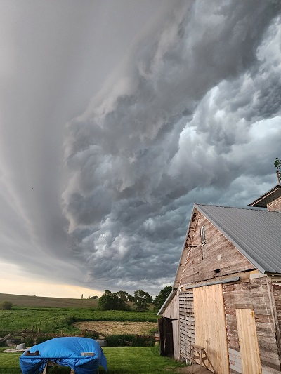
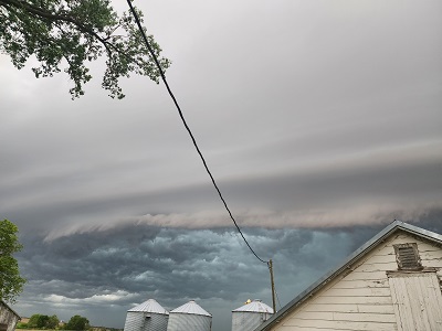
Shelf cloud near Elliott (3 photos) – Submitted to KJAN by Megan Glasgo.
58-mph winds were recorded in Villisca at 7:41-p.m., Sunday. Ping-pong ball size hail fell one-mile SE of Clarinda at 7:55-p.m. Half-dollar size hail (1.25″) fell in Clarinda at 7:49-p.m.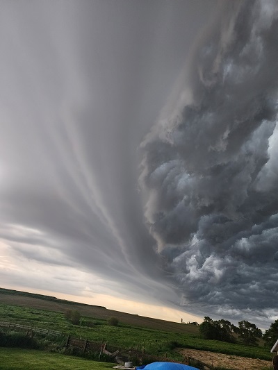

Tornado dissipating
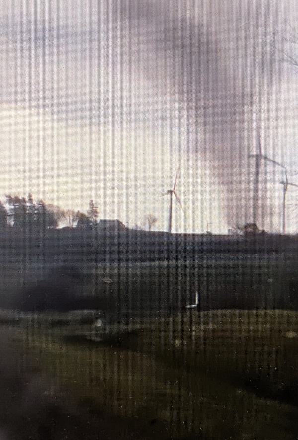
Tornado on the ground
Today: Mostly cloudy with scattered showers & thunderstorms, mainly after 5pm. High near 80. E/NW winds 10-20 mph. A few storms this afternoon and evening may be strong to severe, especially over southern Iowa. Strong winds, hail and locally heavy rainfall will be the primary concerns, but a tornado can`t be ruled out.
Tonight: Mostly cloudy w/a 60% chance of showers & thunderstorms. Low around 62.
Monday: Cloudy to partly cloudy, w/a 40% chance of showers and thunderstorms. high near 81. S/SW @ 5-10 mph. There is the potential for more strong to severe storms in the afternoon and evening hours. Main threats will again be strong winds, hail and locally heavy rainfall, with the potential for a tornado or two as well.
Monday Night: Showers and thunderstorms likely. Low around 62.
Tuesday: Windy. Showers and possibly a thunderstorm. High near 82. SW winds 15-30 mph. Severe storms with damaging winds, large hail, heavy rainfall and tornadoes are possible, but more details on this system will be provided in the coming days.
Tuesday Night: A chance of showers and thunderstorm. Low around 49. Breezy.
Wednesday: Mostly sunny, with a high near 70.
Saturday’s High in Atlantic was 85. Our Low this morning, was 51. Last year on this date, the High in Atlantic was 67 and the Low was 34. The Record High for May 19th was 94 in 1934 & 1975. The Record Low was 22 in 1894. Sunrise: 5:58. Sunset: 8:36.
Today: Sunny, with a high near 84. South wind 5 to 15 mph, with gusts to around 20 mph.
Tonight: Clear, with a low around 57.
Tomorrow: Sunny & breezy. High near 83. South winds becoming N/NW @ 10-20.
Tom. Night: Mostly clear, with a low around 54.
Sunday: Partly sunny & breezy w/a 40% chance of showers & thunderstorms. High near 82.
Sun. Night: Showers and possible thunderstorms. Low around 59.
Monday: P/Sunny w/a 50% chance of shwrs & tstrms. High near 81.
Tuesday: P/Sunny w/a 70% chance of shwrs & tstrms. High near 77.
Thursday’s High in Atlantic was 78. Our Low this morning, was 49. Last year on this date, the High in Atlantic was 84 and the Low was 49. The Record High for May 17th was 92 in 1908 & 1939. The Record Low was 32 in 1912 & 1973. Sunrise: 6:00. Sunset: 8:34.
(Radio Iowa) – The latest report out today shows the amount of drought in Iowa continues to shrink.
The U.S. Drought Monitor shows nearly 53% of the state is now drought free. That compares to September when the entire state was in some sort of drought, and the start of this year when only about three percent of the state had no drought conditions. 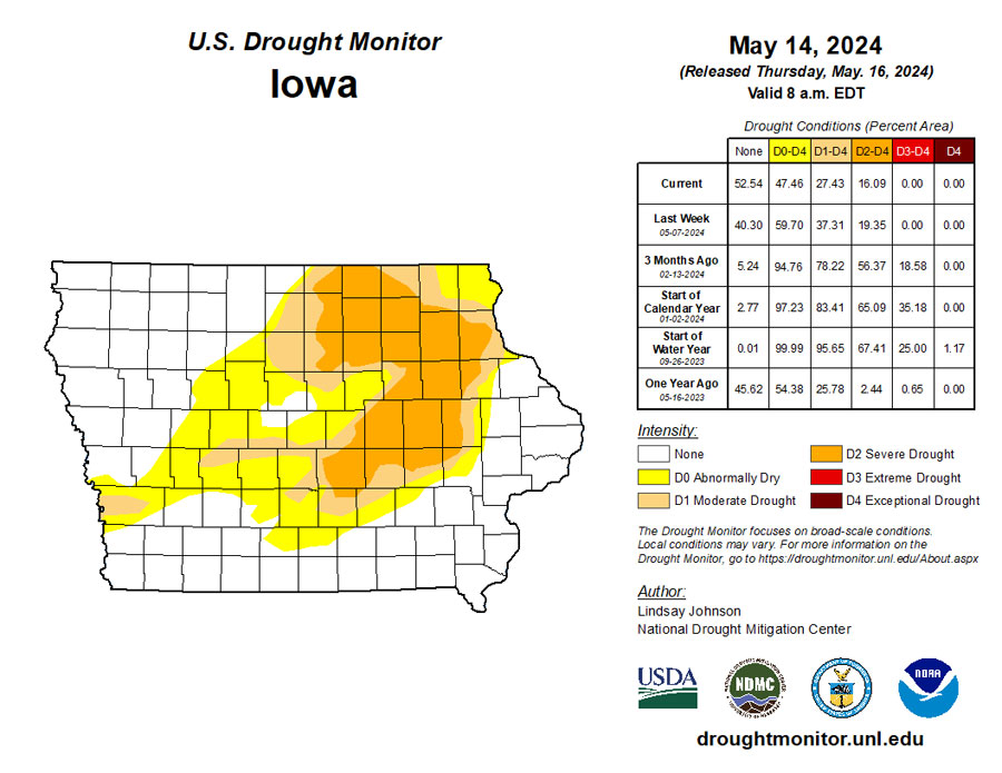
The driest conditions remain in a line from Mitchell County at the northern border down through 23 other counties in northeast and central Iowa. Those counties all have some level of severe drought.
Today: Patchy fog before 9am. Otherwise, partly sunny to sunny. High near 76. West northwest wind 5 to 10 mph.
Tonight: Clear, with a low around 52. .
Tomorrow: Sunny, with a high near 80. South winds 5-to 10-mph in the morning.
Saturday: Sunny, with a high near 83.
Sunday: Partly Sunny w/a 40% chance of showers and thunderstorms, mainly after 1pm. High near 79.
Wednesday’s High in Atlantic was 70. Our Low this morning, 56. We received .32″ rain Wednesday, at KJAN. Last year on this date, the High in Atlantic was 80 and the Low was 48. The Record High for May 16th was 93 in 1939. The Record Low was 25 in 1907. Sunrise: 6:01. Sunset: 8:33.
(Atlantic, Iowa) – KJAN News Director Ric Hanson, today (May 15, 2024), received recognition from the National Weather Service, for 25-years of service in reporting weather observations. KJAN is the OFFICIAL National Weather Service reporting site for Atlantic. Our records (some of which date back to the 1800’s, and were passed-on from previous Cooperative Observers), have been kept at KJAN since the 1950’s.
A Cooperative Weather Observer gathers information with regard to rainfall, accumulated snow, hail and other weather phenomenon. That information is sent daily to the NWS, and is used other media as a reference point, and for historical data.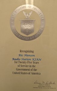

Ric Hanson (Left) receives a 25-year Service Award from NWS Observing Program Leader Marvin Percha.