(Radio Iowa) – When Iowa’s weather gets warmer, the risks rise of a child dying of heatstroke after accidentally being left in a vehicle by a parent or caregiver. It’s a rare tragedy in the state, but it still happens far too often, according to Laura Dunn, a highway safety specialist with the National Highway Traffic Safety Administration. “Unfortunately, seven children have died from heatstroke in Iowa since 1988,” Dunn says, “and the national per capita death rate is about 16.3, and Iowa falls kind of in the mid range at 11.8.” Iowa may not get as hot as Arizona during the summer, but the danger is still significant here. While the risk of hot car deaths is highest when temperatures are hottest, heatstroke can be fatal at any time of year — and at outside temperatures as low as 60 degrees.
“In just about 10 minutes, a car can heat up by about 20 degrees, and that keeps increasing exponentially as time goes on,” Dunn says. “Cracking a window, parking in the shade, it really does very little to help. It’s kind of like what you would call a greenhouse effect.” An average of 37 children die in hot vehicles nationwide every year, and during the summer months, Dunn says it’s roughly two each week.
“We’re launching a new campaign with the Ad Council to remind parents when they park to ‘Stop. Look. Lock.’ and with that, we are hoping to prevent one of the primary ways that hot car deaths happen,” she says, “from a parent or caregiver forgetting their child in a vehicle.” Forgotten children make up about 53-percent of hot car deaths, while some 26-percent of the deaths are from a child getting into a car but they can’t get out. About 20-percent of hot car deaths come from a parent intentionally leaving a child in the car without realizing how quickly it will heat up. Studies show a child’s body temperature rises three-to-five times faster than an adult’s, and when a child’s body temperature reaches 107 degrees or higher, it can lead to death.
“When you park, look in the backseat before locking and leaving the car,” Dunn says. “When you’re driving with your child, make sure that your child’s been dropped off where they’re supposed to be at school or childcare. Keep an item in your vehicle, like a child’s toy, and put that toy up front with you when your child’s in the car seat.” She also suggests leaving something you need during the day — like your phone, a purse or a briefcase — in the back seat with the child.
The NHTSA says heatstroke from hot cars is the leading cause of non-crash, vehicle-related death for kids 14 and younger.
Today: Sunny, with a high near 75.W/NW winds 10-25 mph.
Tonight: Mostly clear, with a low around 47.
Tomorrow: Sunny, with a high near 74. East wind 5 to 10 mph.
Thursday: Partly sunny & breezy, w/a 50% chance of showers & thunderstorms during the afternoon. High near 76.
Friday: Mostly cloudy w/a 50% chance of showers and thunderstorms. High near 69.
Monday’s High in Atlantic was 78. Our Low this morning, was 48. We received .01″ rain Monday (from 7-a.m. to 8-a.m.), at KJAN. Last year on this date, the High in Atlantic was 82 and the Low was 47. The record High for May 28th was 97 in 2018. The record Low was 29 in 1894. Sunrise: 5:50. Sunset: 8:44.
Memorial Day (Monday): Sunny & breezy. High near 75. NW winds @ 15-20 this morning, gusting to near 30 this afternoon.
Tonight: Mostly clear, with a low around 50. NW winds @ 10-25 mph.
Tomorrow: Sunny, with a high near 74.W-NW @ 10-25 mph.
Wednesday: Sunny, with a high near 73.
Thursday: Partly sunny & breezy w/a slight chance of afternoon showers & thunderstorms. High near 75.
Friday: A 50% chance of showers and thunderstorms. High near 72.
Sunday’s High in Atlantic was 81. The Low was 54. Last year on this date, the High in Atlantic was 80 and the Low was 44. The record High for May 27th was 100 in 2018. The record Low was 31 in 1907. Sunrise: 5:51. Sunset: 8:43.
(Omaha/Valley, NE) – Officials with the National Weather Service in Omaha, Sunday, said they had confirmed 12 EF-0 spin-up tornadoes associated with the derecho that moved through the region on Friday, May 24th. The Weather Service says “Quasi-Linear Convective System (QLCS) moved acrossthe area during the late night hours where several scattered tornado spin-ups were reported. QLCS tornadoes tend to be weaker and shorter-lived on average than those associated with supercell thunderstorms.”
In southwest Iowa, tornadoes occurred Friday south of Treynor, 3-miles east of Henderson, and two-miles north of Westphalia. Details are posted below:
..South of Treynor Tornado…
Survey Summary:
This very brief spin up remained near Aspen Road and 300th street south of Treynor. Three grain bins were destroyed as well as numerous trees.
Rating: EF0
Estimated Peak Wind: 83 mph
Path Length /statute/: 0.25 miles
Path Width /maximum/: 60 yards
Fatalities: 0
Injuries: 0
Start Date: 05/24/2024
Start Time: 03:00 AM CDT
Start Location: 4 S Treynor / Pottawattamie County / IA
Start Lat/Lon: 41.175 / -95.6151
End Date: 05/26/2024
End Time: 03:01 AM CDT
End Location: 3 S Treynor / Pottawattamie County / IA
End Lat/Lon: 41.1782 / -95.613
..Henderson Tornado…
Survey Summary:
This brief spin up tornado damaged trees at a farmstead as well as outbuildings.
Rating: EF0
Estimated Peak Wind: 74 mph
Path Length /statute/: 2.09 miles
Path Width /maximum/: 60 yards
Fatalities: 0
Injuries: 0
Start Date: 05/24/2024
Start Time: 03:10 AM CDT
Start Location: 3 E Henderson / Montgomery County / IA
Start Lat/Lon: 41.1316 / -95.3649
End Date: 05/24/2024
End Time: 03:10 AM CDT
End Location: 4 ENE Henderson / Montgomery County / IA
End Lat/Lon: 41.1582 / -95.3457
..Westphalia/Earling Tornado…
Survey Summary:
This brief spin-up tornado damaged roofs off an outbuilding and downed several trees.
Rating: EF0
Estimated Peak Wind: 80 mph
Path Length /statute/: 0.09 miles
Path Width /maximum/: 40 yards
Fatalities: 0
Injuries: 0
Start Date: 05/24/2024
Start Time: 03:13 AM CDT
Start Location: 2 N Westphalia / Shelby County / IA
Start Lat/Lon: 41.7524 / -95.3859
End Date: 05/24/2024
End Time: 03:13 AM CDT
End Location: 2 N Westphalia / Shelby County / IA
End Lat/Lon: 41.7531 / -95.3844
*********
EF Scale: The Enhanced Fujita Scale classifies tornadoes into the following categories:
EF0…Weak……65 to 85 mph
EF1…Weak……86 to 110 mph
EF2…Strong….111 to 135 mph
EF3…Strong….136 to 165 mph
EF4…Violent…166 to 200 mph
EF5…Violent…>200 mph
NOTE:
The information in this statement is preliminary and subject to change pending final review of the events and publication in
NWS Storm Data.
These are 24-hour rainfall totals (7-a.m. Saturday, May 25th through 7-a.m. Sunday, May 26th), from around the listening area:
KJAN, .4″
Anita, .20″
Audubon, .52″*
Carroll, .01″
Clarinda Airport, .43″*
Corning, .34″
Creston Municipal Airort, .32″*
Denison, .56″
Elk Horn, .25″
Harlan, .15″
Massena, .35″
Red Oak, .23″
Shenandoah Municipal Airport, .08″
Stanton, .12″
Wiota, .21″
Greenfield, 3.00″
DES MOINES, Iowa [KCCI] — The line of severe storms that swept across Iowa Friday morning was in fact a derecho (pronounced “duh-RAY-cho”). That confirmation came from the Storm Prediction Center, which determined the powerful system met its criteria after plowing through the Midwest from Nebraska all the way to Illinois.
In simple terms, a derecho is a complex of thunderstorms that produces straight-line wind damage over a very long path. That damage path has to exceed 400 miles in length and must be at least 60 miles wide. Wind gusts have to exceed 58 mph (severe thunderstorm criteria) over most of the path, with occasional gusts above 75 mph.
The derecho that walloped Iowa Friday morning checked all those boxes. Reports of 60-70 mph gusts first came out of southwest Nebraska Thursday night. By 3 a.m. Friday, severe winds had arrived in western Iowa and would persist all the way into Illinois.
In Iowa, gusts above the 58 mph threshold were reported as far north as Estherville, and as far south as Highway 92, making the damage swath well over 100 miles wide. Finally, the system produced multiple high-end wind gusts (75+ mph) along its path, including an 83 mph gust in Monona County, 75 mph winds in Greenfield, and an 84 mph gust recorded near Newton.
Many Iowans hadn’t heard of derechos until a particularly powerful one struck Aug. 10, 2020.
Derechos actually happen with some regularity but are rarely as strong as the 2020 storm.
Historically, part of Iowa experiences a derecho every 1-2 years. Since 2010, a total of 14 derechos have hit somewhere in the state.
TODAY: Mostly cloudy with 30% chance of showers & thunderstorms, mainly this afternoon. High around 74. Winds East at 5-to 10-mph this morning, shifting to the North this afternoon.
TONIGHT: A slight chance of showers this evening. Gradually becoming mostly clear overnight. Low around 53.
TOMORROW [MEMORIAL DAY]: Sunny & windy, with a high near 75. W/NW winds @ 10-20 w/afternoon gusts to near 30 mph.
TOM. NIGHT: Clear, with a low around 49.
TUESDAY: Sunny, with a high near 75.
WEDNESDAY: Sunny, with a high near74.
THURSDAY: Partly sunny w/a 40% chance of showers and thunderstorms during the afternoon. High near 78.
Saturday’s High in Atlantic was 77. The Low was 51. We received .4 (four-tenths) of an inch of rain early this morning at KJAN. Last year on this date, the High in Atlantic was 79 and the Low was 41. The record High for May 26th was 100 in 2018. The record Low was 30 in 1901. Sunrise: 5:52. Sunset: 8:42.
Today: Partly cloudy to cloudy. High near 75. S/SW winds 10-25 mph.
Tonight: Showers & thunderstorms developing. Low around 56.
Sunday: Mostly cloudy w/a60% chance of showers & thunderstorms. High 73. SE winds becoming N/NW @ 10-20 mph.
Sunday Night: Cloudy to partly cloudy w/a30% chance of showers & thunderstorms. Low 50.
Memorial Day: Sunny to Partly sunny, w/ slight chance of afternoon showers & thunderstorms. High 75.
Tuesday: Sunny, with a high near 74.
Wednesday: Sunny, with a high near 76.
Friday’s High in Atlantic was 71. The Low was 44. Last year on this date, the High in Atlantic was 82 and the Low was 58. The record High for May 25th was 98 in 1967. The record Low was 30 in 1925. Sunrise: 5:53. Sunset: 8:40.

 *Note, this is from the parent storm of the Greenfield tornado, as the storm cycled in northeast Adair County.
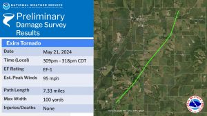
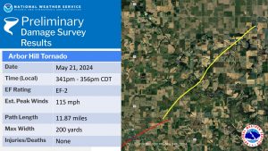
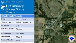
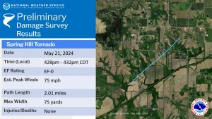
 3) Martensdale Tornado – EF-0 – northwest Warren County
 As post-event analysis continues, results above remain preliminary and are subject to change and refinement.