
(Radio Iowa) — While it was slow to develop, it appears the effects of the current El Nino weather pattern will hang around the region for a while — likely several months. Meteorologist Dennis Todey, director of the U-S-D-A’s Midwest Climate Hub, based in Ames, says they expect a longer-than-average El Nino, which typically means warmer, wetter weather for Iowa. “March, April, May, all the way to June, July, August and September,” Todey says. “The probability of El Nino is the highest staying above 60% most of the way through the summer, so, we’re expecting that to be with us.”
An El Nino occurs when Pacific Ocean surface temperatures rise, which in turn impacts weather across North America. An El Nino can last just nine to 12 months or sometimes as long as seven years. Todey says the center is predicting warmer-than-normal temperatures at least through early summer. “The chances for May temperatures lean slightly towards the warm side over most of the eastern part of our region,” Todey says. “Parts of Kansas and Colorado have a slightly increased chance of below-average temperatures and the warm extends through the Northern Plains. None of these probabilities are very high, a little bit in the eastern part of the Corn Belt.”
Todey says the long-range outlooks calls for above-normal rainfall for most of the summer. “It is an interesting contrast when we look at the precipitation probabilities,” he says. “This is a 50% chance of above-average precipitation. That’s fairly high and this whole area is actually fairly high, given we’re in a May-to-July, more convective time of season. It’s not often you see this from the climate prediction center.” It follows a snowy winter and a rainy early spring which led to record flooding on the Missouri River and significant flooding on the Mississippi and elsewhere, with billions of dollars damage in Iowa and several neighboring states.
The National Weather Service says thunderstorms are likely across much of Iowa on Wednesday and into early Wednesday night. There will be a threat of severe weather with some of the storms, especially from late in the day through the evening. Large hail and damaging winds will be the primary threats, but there is a possibility of isolated tornadoes as well. The primary threat seems to have shifted further east (Des Moines and southeast/southern Iowa), but the risk of severe weather in the KJAN listening area cannot be ruled out.
Now is a good time to review your severe weather plan, and be sure to monitor the latest forecast updates leading up to Wednesday!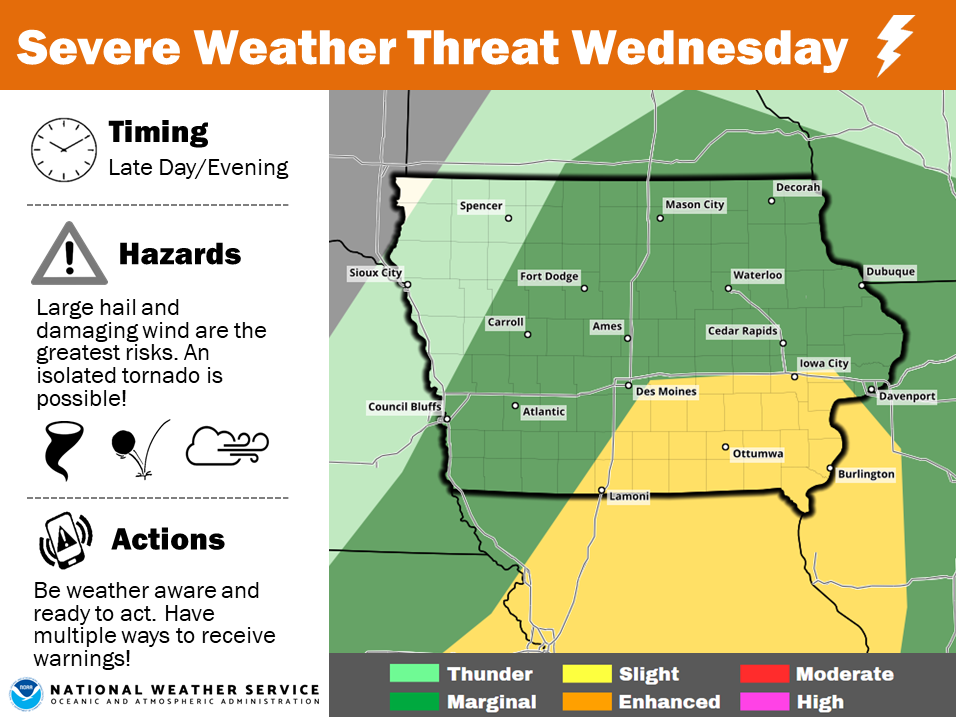
Today: Partly-to-Mostly sunny. High around 68. S winds @ 10-15 w/gusts to near 25.
Tonight: Partly cloudy, with a low around 45. SE @ 10-15 becoming calm after midnight.
Tomorrow: Partly cloudy. High near 70. SE @ 10-15 mph.
Tom. night: Mostly cloudy w/a 40% chance of showers and thunderstorms. Low around 56.
Wednesday: Mo. Cldy w/a 50% chance of showers and thunderstorms. High near 70.
Thursday: Cloudy w/rain likely, especially in the morning. High near 55.
Yesterday’s High in Atlantic was 54. Our 24-hour Low (Ending at 7-a.m.) was 29. Last year on this date our High was 31 and the Low was 20. The record High in Atlantic on this date was 84 in 1920. The Record Low was 17 in 1926 & 1962.
Today: Partly sunny, then gradually becoming sunny, with a high near 53. North wind 6 to 8 mph.
Tonight: Partly cloudy, with a low around 37. Calm wind becoming southeast 5 to 9 mph after midnight.
Monday: Mostly sunny, with a high near 69. South wind 10 to 15 mph, with gusts as high as 25 mph.
Monday Night: Partly cloudy, with a low around 48. South wind 5 to 9 mph becoming east after midnight.
Tuesday: Partly sunny, with a high near 74. East wind 7 to 10 mph.
Tuesday Night: A 40 percent chance of showers and thunderstorms. Mostly cloudy, with a low around 56. New rainfall amounts of less than a tenth of an inch, except higher amounts possible in thunderstorms.
Wednesday: A 50 percent chance of showers and thunderstorms. Mostly cloudy, with a high near 74.
![]() Officials with the National Weather Service remind area listeners, that the weather radio transmitter site at Hancock remains off-air due to ice and snow this past winter, and it’s not known how long the repairs will take, but the transmitter will be repaired as quickly as possible.
Officials with the National Weather Service remind area listeners, that the weather radio transmitter site at Hancock remains off-air due to ice and snow this past winter, and it’s not known how long the repairs will take, but the transmitter will be repaired as quickly as possible.
If you have a weather radio you will not be able to receive warnings for storms in Cass and Audubon Counties. You should have other forms of staying alert to changing weather situations, by cell phone, radio or tv. Subscribe to your county’s Emergency Alert Notices through your Emergency Management Agency for immediate weather and civil emergency bulletings.
Skyscan Forecast Saturday, Februrary 13, 2019
Today: Sunny, with a high near 52. West southwest wind 5 to 10 mph becoming north northwest in the afternoon.
Tonight: Mostly cloudy, with a low around 30. North northeast wind 5 to 10 mph.
Sunday: Partly sunny, then gradually becoming sunny, with a high near 52. North northeast wind around 10 mph.
Sunday Night: Partly cloudy, with a low around 36. Northwest wind 5 to 10 mph becoming southeast after midnight.
Monday: Mostly sunny, with a high near 68. Breezy, with a south wind 10 to 15 mph, with gusts as high as 25 mph.
Monday Night: Partly cloudy, with a low around 46.
Tuesday: Partly sunny, with a high near 72.

Podcast: Play in new window | Download (511.8KB)
Subscribe: RSS
Today: Partly cloudy to cloudy & windy. High 43. W/NW @ 20-40.
Tonight: Clearing skies. West winds diminishing to 10-15 mph. Low 25.
Tomorrow: P/Cldy. High 52. NW @ 10.
Sunday: Mo. Cldy. High 52.
Monday: P/Cldy. High 64.
Yesterday’s High in Atlantic was 52. Our Low this morning (as of 5-a.m.) was 31. We received a Trace of rain (sprinkles) Thursday. Last year on this date our High was 70 and the Low was 40. The record High in Atlantic on this date was 86 in 1916. The Record Low was 13 in 1957.
(Radio Iowa/A-P) — The second so-called bomb cyclone in less than a month is bringing Iowa a mix of snow, ice, rain, high winds and the threat of flooding, hail and tornadoes. Blizzard conditions have knocked out power to 14,000 people and businesses in Minnesota and the same number in South Dakota. Another 8,500 are in the dark in Iowa. Meteorologist Kenny Podrazik, at the National Weather Service in metro Des Moines, says advisories and warnings about the high winds are posted for a wide section of northern and central Iowa.
“We’ve had some reports of wind gusts as high as 63 miles per hour, Fort Dodge had wind gusts of 63 miles per hour,” Podrazik says. “We’re starting to get reports of tree damage, too, and the Iowa DOT reported power lines down across northern Iowa.” MidAmerican Energy reports some 18-hundred homes and businesses were without power this (Thursday) morning, while Interstate-35 northbound near Dows was blocked due to a semi that was blown onto its side. An Ice Storm Warning is in effect until Friday morning for parts of northwest Iowa, while several northern counties are seeing snowfall, enough to delay school two hours in some areas. Podrazik says there’s a threat of more severe weather coming this afternoon.
“That’s mainly across the eastern portion of the state, I-35 towards Iowa City, Cedar Rapids, Waterloo, Davenport area,” Podrazik says. “That threat is looking like hail and maybe even a small, isolated tornado threat, too.” The first bomb cyclone brought snow and heavy rain a little over three weeks ago, which translated into record flooding in parts of southwest Iowa. There were fears this storm would bring a repeat of the flooding. “There is still a threat for that,” Podrazik says. “Some of that snow and rain and mixed precipitation fell into the upper Des Moines River basin so it’ll take a little bit of time to see the impacts of that but not as significant as what we were previously thinking earlier in the week, which is a good thing.”
As much as 18 inches of snow has fallen in parts of South Dakota, where Gov. Kristi Noem closed state offices in much of the state Thursday amid heavy snow and strong winds. Whiteout conditions have been reported in western Nebraska, where the Department of Transportation reported several highway closures Thursday morning. Schools in Minneapolis and St. Paul are among hundreds of closed schools in Minnesota, where as much as 2 feet of snow is expected in the southwest part of the state by Friday. The Minnesota State Patrol says it has responded to more 200 crashes statewide since Wednesday.
While some Iowans were outside in shorts and t-shirts on Monday as high temperatures soared into the 70s and low 80s, highs statewide on Friday may only be in the 30s and 40s. The forecast calls for temperatures to warm back into the 60s and 70s by early next week.


