
Today: **WIND CHILL ADVISORY until 9-a.m.**Scattered flurries/isolated snow showers this morning. Partly cloudy. High 8. N @ 10-15. Wind chill values as low as -15
Tonight: Fair to P/Cldy. Low -10. Winds light and variable.
Tomorrow: P/Cldy. High 22. S @ 10-15.
Wednesday: Mostly cloudy w/light snow and/or rain mixed. High 35.
Thursday: Mo. Cldy w/light snow. High 34.
Sunday’s High in Atlantic was 7. Our Low this morning (as of 5-a.m.) was -10. Last year on this date the High was 13 and the Low 6. The Record High in Atlantic on Jan. 20th was 64 in 1895. The Record Low was -26 in 1962.
Early this morning: Clear, with a steady temperature around -2. Wind chill values as low as -20. Blustery, with a northwest wind around 16 mph, with gusts as high as 23 mph.
Today: **WIND CHILL ADVISORY until Noon**Sunny and cold, with a high near 6. Wind chill values as low as -25. Blustery, with a northwest wind 8 to 16 mph, with gusts as high as 25 mph.
Tonight: Scattered flurries after 5am. Partly cloudy, with a low around -7. Wind chill values as low as -15. North northwest wind 5 to 7 mph.
M.L.King Day: Scattered flurries before noon. Mostly cloudy, then gradually becoming sunny and cold, with a high near 6. Wind chill values as low as -15. North wind 3 to 7 mph.
Monday Night: Mostly clear, with a low around -10. Calm wind becoming south around 5 mph after midnight.
Tuesday: Mostly sunny, with a high near 26.
Tuesday Night: A 20 percent chance of snow after midnight. Mostly cloudy, with a low around 19. Breezy.
Wednesday: A chance of rain and snow before 1pm, then a chance of rain between 1pm and 5pm, then a chance of rain and snow after 5pm. Cloudy, with a high near 37. Breezy. Chance of precipitation is 50%.
Saturday’s High in Atlantic was 14. Our Low this morning (as of 6:30-a.m.) was -4.
Skyscan Forecast Saturday, January 18, 2020 Dan Hicks
Audubon-Guthrie-Dallas-Cass-Adair-Madison Counties: A WINTER STORM WARNING REMAINS IN EFFECT UNTIL 6 PM.
Adams-Union-Taylor-Ringgold Counties: A WINTER WEATHER ADVISORY REMAINS IN EFFECT UNTIL 6 PM
Shelby-Pottawattamie-Mills-Montgomery-Fremont-Page Counties: WIND ADVISORY IN EFFECT UNTIL 1 PM.; Northwest winds 25 to 35 mph with gusts up to 50 mph expected.
Shelby County: A WINTER WEATHER ADVISORY REMAINS IN EFFECT UNTIL 6 AM…A WIND CHILL ADVISORY WILL BE IN EFFECT FROM 4-A.M. SUNDAY UNTIL NOON, SUNDAY.
Monona-Harrison Counties: A HIGH WIND WARNING REMAINS IN EFFECT UNTIL 8 AM. A WIND ADVISORY WILL THEN BE IN EFFECT FROM 8 AM TO 1 PM TODAY.
Sac-Crawford-Carroll Counties: A WINTER STORM WARNING REMAINS IN EFFECT UNTIL 6 AM; A BLIZZARD WARNING REMAINS IN EFFECT FROM 6 AM TO 6 PM TODAY
Today: Light snow this morning. Strong winds with blowing and drifting of snow. Cloudy becoming partly cloudy late today. NW @ 20-40. Temperatures falling through the teens today to around 10 this afternoon.
Tonight: Becoming fair to partly cloudy. NW diminishing to 10-15. Low -6.
Sunday: Mostly sunny. NW @ 10-15. High 8.
Monday: Mostly sunny. High 10.
Tuesday: Partly cloudy. High 20.
Yesterday’s High at the KJAN studios was 33 and the low this morning at 16. We picked up 5″ of snow in Atlantic with an additional .1″ of ice glazing.

Podcast: Play in new window | Download (2.8MB)
Subscribe: RSS
DES MOINES, Iowa (AP) – A winter storm dropping several inches of snow and sleet and also bringing in high winds lead to cancellations of classes, activities and services across Iowa on Friday. About half of flights from the Des Moines International Airport, where more than 4 inches of snow fell by midday Friday, were canceled or delayed. More cancellations were likely as the National Weather Service issued winter weather and storm advisories for most of the state. The northwestern corner of Iowa, including Sioux City and Storm Lake, was under a blizzard warning through Saturday.
TODAY: **Winter Weather Advisory for snow & mixed precip. until 6-p.m. Saturday for Cass & most area Counties**Cloudy & windy, w/snow, sleet and freezing rain – mixed at times this afternoon. High 31. SE @ 15-20. (2-4″ of snow is possible).
TONIGHT: Cloudy w/light mixed precip. becoming light snow late. Low 20. NW @ 10-20.
TOMORROW: Cloudy & windy, w/light snow ending in the morning; Becoming partly cloudy. High 20. NW @ 20-40.
SUNDAY: P/Cldy. High 12.
MONDAY: P/Cldy. High 15.
Thursday’s High in Atlantic was 19 (the 24-hour High ending at 7-a.m today). Our Low was -4. We received 1″ of snow from 5-a.m. up until 7-a.m., today. Last year on this date, the High was 30 and the Low was 21. The Record High for Jan. 17 in Atlantic, was 57 in 1989. The Record Low was -21 in 1984.
Heartbeat Today, Podcasts, Weather
Chris Parks speaks with Freese-Notis Meteorologist Dan Hicks about the expected impact of the winter storm moving into the Nishna Valley on Friday.
Podcast: Play in new window | Download (23.9MB)
Subscribe: RSS
(Radio Iowa) — Gas up the snowblower and prepare to dress in multiple layers. For the second weekend in a row, Iowans are bracing for the approach of what’s billed as a significant winter storm. Meteorologist Cory Martin, at the National Weather Service, says the snowfall forecast has been downgraded somewhat, but he says the storm’s potential impact on travel isn’t any less threatening. “We’re expecting snow to begin moving into the state tomorrow morning and spread across most of the state as we get into the afternoon hours,” Martin says. “As we get into late afternoon and into the evening, the snow will likely come to an end and switch over to a period of potential freezing rain or freezing drizzle.”
While the initial forecast predicted parts of northern Iowa might see up to a foot of snow, the updated models now show much less snow — but plenty of very cold air — on the way. “Just through the day tomorrow, across the state, we’re looking at across the southern part of the state, possibly three to five inches and up across the north, we may see up to six inches of snow,” Martin says. “Then, we’re going to be dealing with some strong southerly winds tomorrow, which could create areas of blowing snow in addition to the slick roadways from the already-falling snowfall.” 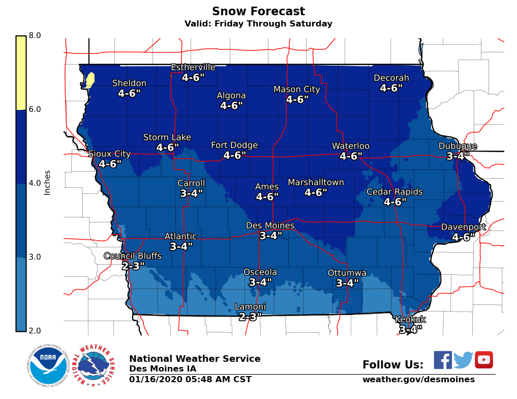
The moderate-to-heavy snowfall and gusting winds are already enough to keep most of us indoors, but Martin notes the extreme cold will make going outside after the storm even more hazardous. “We could have some really strong winds behind it on Saturday that could create more issues with blowing snow, especially if we pick up some more light snowfall Saturday morning,” Martin says. “Forty and 50 mile-an-hour wind gusts could be common on Saturday along with drastically falling temperatures. Sunday morning, we’re looking at wind chills that could be minus-10, minus-20 or colder.”
Air temperatures alone on Sunday are expected to only be in the single digits statewide. Martin says temps should stay below-average for most of the state at least into the middle of next week.
Today: Mostly sunny. High near 20. N winds @ 10 mph shifting to the East. Wind Chills as low as -15.
Tonight: Cloudy w/light snow developing late (Little or no snow accumulation expected.). Low 13 w/temps nearly steady or slowly rising overnight. SE @ 10-15.
Tomorrow: **WINTER STORM WATCH IN EFFECT from 6-a.m. Friday thru 6-p.m. Saturday**Snow in the morning becoming mixed w/sleet-rain-freezing rain in the afternoon. High 32. SE @ 15-25. New ice accumulation of less than a 0.1 of an inch possible. New snow accumulation of 2 to 4 inches possible.
Tom. Night: Freezing rain before midnight, then a chance of snow and freezing rain. Patchy blowing snow. S @ 15-30 w/gusts to near 40 mph. Low around 15. New ice accumulation of around a 0.1 of an inch possible. New snow accumulation of less than a half inch possible.
Saturday: Mo. cldy & windy, w/light snow & patchy blowing snow, mainly in the morning. High around 20. NW @ 25-45 mph.
Sunday: P/Cldy & cold. High around 12.
Wednesday’s High in Atlantic was 28. Our Low this morning (The 24-hour Low ending at 7-a.m.) was -3. Last year on this date, the High in Atlantic was 25 and the Low was 15. The record High for Jan. 16th in Atlantic, was 64 in 1990. The Record Low was -25 in 2009.
OMAHA, Neb. (AP) – A federal report says Nebraska suffered more than $3.4 billion in losses from disastrous weather last year while the toll was $1.9 billion in neighboring Iowa. The bomb cyclone in March caused most of the damage. The report says the rain and snowmelt runoff led to record flooding in eastern Nebraska and in Iowa. The Omaha World-Herald reports that the Nebraska drought of 2012 was the state’s costliest weather disaster on record, causing an estimated $4 billion in losses.
Iowa’s costliest year was 1993, when the state sustained more than $11 billion in losses, mostly from flooding.
Today: **Winter Weather Advisory for freezing drizzle in effect until 9-a.m.** Cloudy w/patchy freezing drizzle changing to flurries before ending. High early around 32, w/temps falling during the day. NW @ 15-30 mph.
Tonight: Partly cloudy. Low 0. NW @ 5-10.
Tomorrow: P/Cldy. High 22. SE @ 5-10.
Friday: Cldy w/a chance of snow/mixed precip. (rain/freezing rain/snow). High near 32.
Saturday: Cldy w/light snow in the morning. High 24.
Tuesday’s High in Atlantic was 35. Our Low 22. Last year on this date, the High in Atlantic was 33 and the Low 18. The Record High here on Jan. 15th, was 61 in 1990, and the Record Low was -23 in 1905.


