
(Radio Iowa) — The end of June means the end of peak tornado season in Iowa. Twisters can strike during any month but they’re typically the worst here during April, May and June. Meteorologist Brad Small, at the National Weather Service, says it’s been a relatively quiet season for severe weather in the state. “Tornadoes have been down a little bit. We’ve only issued 14 warnings in the Des Moines/Central Iowa forecast office. We don’t really keep too many numbers on that as far as records, but that’s on the low side,” Small says. “If you look at severe thunderstorm and tornado warnings combined, we’re in the lowest 25% of all the years since the mid-80s.”
There have been 23 reports of tornadoes in Iowa so far in 2020. In all of 2019, there were 54 tornadoes, while in 2018, the total reached 69 twisters. Conditions simply haven’t been conducive for many tornadoes this season, Small says, not that he’s complaining. “The pattern just hasn’t set up too well,” he says. “You’ve got to have a lot of instability and a lot of wind shear combined. There’s been some episodes where it’s been cooler, so we haven’t had a lot of that instability earlier this spring. Those two elements just haven’t come together too well.”
Small advises Iowans not to get complacent as severe weather, including tornadoes, can develop in fall and winter. Iowa has even recorded December and January tornadoes, though they’re rare. No severe weather is likely for the foreseeable future in Iowa. Forecasters say warm and humid conditions will persist into the 4th of July weekend.
Today: Showers & thunderstorms ending this morning; Becoming partly sunny, hot & breezy. High near 91. Heat index values as high as 100. S/SE winds 5-15 mph w/gusts to around 25.
Tonight: Partly cloudy w/a 30% chance of showers & thunderstorms. Low around 72. S/SE @ 15-25 mph.
Monday: A slight chance of showers in the morning, otherwise mostly sunny & breezy. High near 90. S @ 15-25.
Monday Night: Mostly cloudy & breezy, w/a slight chance of showers & thunderstorms after 1am. Low 71.
Tuesday: Partly sunny w/a slight chance of afternoon showers & thunderstorms. High near 90.
Tuesday Night: A chance of showers and thunderstorms, mainly after midnight. Low around 72.
Wednesday: Partly sunny w/a 40% chance of showers & thunderstorms, mainly after 1pm. High near 90.
Saturday’s High in Atlantic was 87. Our Low, 67. We received .09″ rain between 5-a.m. and 7-a.m. today at the KJAN studios (24-hour total). Last year on this date the High in Atlantic was 89 and Low, 71. The Record High on this date was 103 in 1936, and the Record Low was 50 in 1896 & 2006.
Severe Thunderstorm Warning
National Weather Service Omaha/Valley Nebraska
351 AM CDT Sun Jun 28 2020

The National Weather Service in Omaha has issued a

* Severe Thunderstorm Warning for...
  Fremont County in southwestern Iowa...
  Southeastern Mills County in southwestern Iowa...
  Central Nemaha County in southeastern Nebraska...
  Eastern Otoe County in southeastern Nebraska...

* Until 415 AM CDT.

* At 351 AM CDT, severe thunderstorms were located along a line
  extending from 5 miles northwest of Nebraska City to Auburn, moving
  east at 60 mph.

  HAZARD...60 mph wind gusts and penny size hail.

  SOURCE...Radar indicated.

  IMPACT...Expect damage to roofs, siding, and trees.

* Locations impacted include...
  Nebraska City, Shenandoah, Auburn, Syracuse, Hamburg, Sidney, Peru,
  Farragut, Johnson, Riverton, Talmage, Lorton, Thurman, Dunbar,
  Otoe, Randolph, Brownville, Brock, Imogene and Julian.

This includes Interstate 29 between mile markers 1 and 17.

PRECAUTIONARY/PREPAREDNESS ACTIONS...

For your protection move to an interior room on the lowest floor of a
building.
Today: Cloudy to Partly Cloudy. High 86. S @ 10.
Tonight: P/Cldy. Low 71. SE @ 10.
Sunday: Mo. Cldy & humid. High 91. S @ 10-20.
Monday: P/Cldy & humid. High 92.
Tuesday: P/Cldy to Cldy & humid. High 93. S @ 10-15.
Friday’s High in Atlantic was 89. Our Low this morning, 67. We received just .01″ rain Friday morning. Last year on this date the High in Atlantic was 89 and Low, 73. The Record High on this date was 103 in 1934, and the Record Low was 43 in 1938, 1958 & 1968.
Today: Partly cloudy. High 87. SW 15.
Tonight: P/Cldy & humid. Low 66. NW @ 10.
Tomorrow: P/Cldy to Cloudy. High 84. SE @ 5.
Sunday: P/Cldy & humid. High 91.
Monday: Mo. Cldy & humid. High 92.
Thursday’s High in Atlantic was 90. Our Low, 55. Last year on this date the High in Atlantic was 84 and Low, 64. The Record High on this date was 103 in 1934 & 1936, and the Record Low was 43 in 1902.
(Radio Iowa) — A massive thunderstorm in Africa’s Sahara Desert created an enormous dust cloud thousands of feet high and the plume that’s made a six-thousand mile journey across the Atlantic Ocean may impact Iowa this weekend. State climatologist Justin Glisan says it’s an exceptionally rare event.
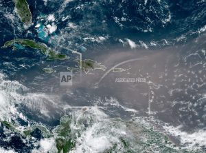
This satellite photo provided by the National Oceanic and Atmospheric Administration, NOAA, shows a could of dust coming from the Sahara desert arriving to the Caribbean Monday, June 22, 2020. The massive cloud of dust is blanketing the Caribbean as it heads to the U.S. with a size and concentration level that meteorologists say hasn’t been seen in roughly half a century. (NOAA via AP)
“They’re calling it the Godzilla plume because we haven’t seen a dust plume from West Africa stay together in the spatial scale that it is in over 50-to-60 years,” Glisan says. “It’s a unique phenomena that we’re seeing.” People who have compromised immune systems, especially those who may have COVID-19, are warned to stay indoors as much as possible for the next several days.
“We should see some affect of the plume in basically air quality, more particulate in the air,” Glisan says. “People with breathing problems will see increased aerosols near the surface and that will produce breathing problems.” Depending on how the jet stream moves the dust across the country and into the Midwest, photographers in Iowa may have a golden opportunity to shoot some gorgeous pictures thanks to the plume, especially at dawn and dusk.
“Because you have that particulate in the air, it acts to scatter sunlight towards the prettier colors of the spectrum, red, pink, purple,” he says, “so we should see very lovely sunrises and sunsets.” Car washes in Iowa could be busier next week, as Glisan says we may see a thicker coating of dust on our vehicles than usual, especially if they’re not in a garage. Outdoor plants, too, will get dusty, although farmers likely won’t need to be worried about their crops.
“We won’t see major affects on agriculture, but, if you think about how you have dust in the atmosphere, that limits the amount of sunlight that gets to the surface and to the leaf area of corn and soybeans,” Glisan says. “It might limit photosynthesis but being a short-lived event, I don’t think it will have a major impact on things.”
The skies may not appear as blue for the next several days either, he says, as the dust makes the air far above us whiter, much like when there’s a big forest fire in Canada and the smoke is carried here on the wind.
Today: Partly cloudy. High 85. SE @ 10.
Tonight: P/Cldy w/isolated showers & thunderstorms. Low 65. SE @ 5-10.
Tomorrow: P/Cldy w/isolated shwrs & tstrms. High 89. S @ 10-20.
Saturday: P/Cldy to cloudy w/showers & thunderstorms likely in the morning. High 85.
Sunday: P/Cldy to cldy w/scattered showers & tstrms. High near 90.
Wednesday’s High in Atlantic was 84. Our Low this morning, 51. Last year on this date the High in Atlantic was 82 and Low, 62. The Record High on this date was 106 in 1937, and the Record Low was 40 in 2004.
Today: Partly cloudy. High 79. NW @ 10.
Tonight: Fair to P/Cldy. Low 58.
Tomorrow: P/Cldy. High 83. SW @ 10.
Friday: P/Cldy w/isolated showers & thunderstorms. High 88.
Saturday: P/Cldy to cldy w/scattered showers & tstrms, especially in the morning. High 85.
Tuesday’s High in Atlantic was 78. Our Low this morning, 50. Last year on this date the High in Atlantic was 80 and Low, 61. The Record High on this date was 105 in 1937, and the Record Low was 41 in 1961.
Today: Partly cloudy. High 77. N @ 10-15.
Tonight: P/Cldy. Low 55. N @ 5.
Tomorrow: P/Cldy. High 79.
Thursday: A chance of afternoon showers & thunderstorms. High 83.
Friday: P/Cldy w/isolated showers & tstrms. High 88.
Monday’s High in Atlantic was 81. Our Low this morning, 58. Last year on this date the High in Atlantic was 77 and Low, 60. The Record High on this date was 105 in 1937, and the Record Low was 44 in 1958.
Today: Partly cloudy to cloudy w/scattered showers. High 79. NW @ 10-15.
Tonight: Fair to P/Cldy. Low around 57. NW @ 5-10.
Tomorrow: P/Cldy. High 77. NW @ 10-15.
Wednesday: P/Cldy. High 79. Thursday: P/Cldy w/scattered thunderstorms. High 83.
Sunday’s high was 89 and last night’s low was 65. This day last year we had a high of 81 and a low of 64. The all-time record high on June 22nd was 100 degrees in 1933 and the record low was 39, in 1972. Sunset tonight is at 8:57-a.m. and sunrise tomorrow is 5:46-a.m.


