
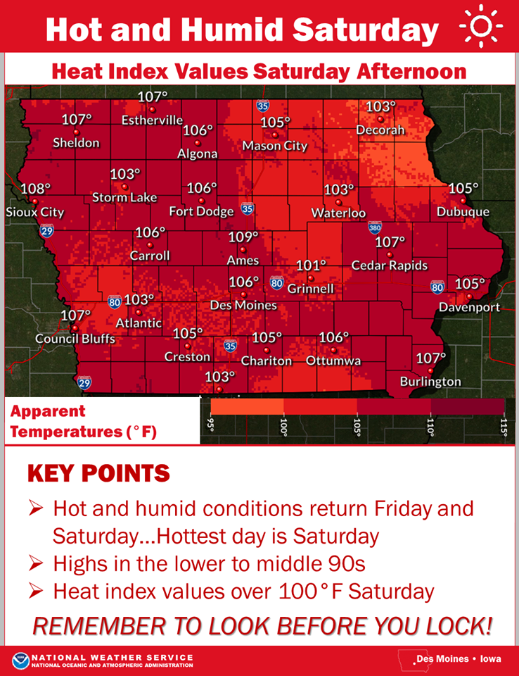
The National Weather Service in Des Moines says hot and humid conditions will return Friday and Saturday. The hottest day is forecast to be on Saturday when high temperatures will rise into the middle 90s and heat index values of 101 to 109°F are anticipated by the afternoon hours! Still sticky on Sunday, but temperatures will range around 90°F for highs and there will be storm chances late in the evening into Monday morning.
Monona-Harrison-Shelby-Pottawattamie-Mills-Montgomery-Fremont-
Page Counties: A DENSE FOG ADVISORY IS IN EFFECT UNTIL 8 AM TODAY (7/16).
Elsewhere: Patchy dense fog has developed across portions of central to north central Iowa early this morning. Variable visibility at times. This means while traveling, you may come across an abrupt visibility restriction to less than one half mile. This likely to cause tricky difficult through at least 6 AM this morning. Use low beam headlights and allow extra space between you and the vehicle ahead of you.
(Radio Iowa) – You know it’s a bad storm when the National Weather Service staff has to abandon its office and take shelter underground. Severe storms rolled across central Iowa last (Tuesday) night, bringing winds up to 60 miles an hour in the Des Moines area, along with two-inch diameter hail and heavy rain. Meteorologist Frank Boksa, at the Weather Service, says it was a very active evening. “We had a funnel cloud reported near Boone around 6:40,” Boksa says. “There were only a couple reports of what I would consider very large hail, Grimes and Ankeny. Several locations had trees down, Windsor Heights and the town of Saylorville. Numerous reports of quite heavy rain, two-to-four inches of rain.”
There were multiple reports of “rotation” seen on radar, a possible indicator of a tornado, but no twisters are confirmed. Boksa says their Johnston office had to be evacuated for a short time as a particularly nasty storm cell approached. “It did have a tornadic signature to it so the people who were working here during the evening took cover as the storm passed over the office,” Boksa says. “We have a storm shelter that we go into.”
While the Des Moines office was temporarily closed, forecasting duties were shifted to the National Weather Service bureau in the Quad Cities. Skies are grey across much of Iowa this morning but Boksa says the immediate threat of more severe weather is over. “We’ll see some thunderstorms through the morning, diminishing in the afternoon,” Boksa says. “The severe threat is really passed. It’s more of a heavy rain threat now.” Multiple power outages were reported and damage, primarily to houses and trees, is also reported in Pella, Sandyville, West Des Moines and Urbandale. No injuries were reported.
The National Weather Service reports severe thunderstorms are possible across much of the area this afternoon and tonight. There is a slight risk of severe storms primarily this afternoon and evening but storms may linger overnight. The main time-frame is from 3-until 11-p.m. Large hail, damaging wind and heavy rainfall are the main threats. Unfortunately, for western and parts of southwest Iowa, there is only a marginal to slight risk of excessive rainfall, while some areas could see anywhere from one-to-three inches of rain.
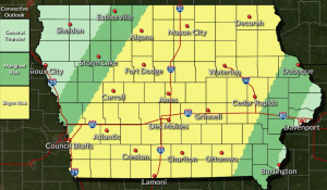 Tornadoes are a secondary threat with today’s weather. Hot and humid conditions will exist this weekend. Heat index values may be in the 100 to 105 degree range. Additional thunderstorms are forecast Sunday evening. Some storms may be severe but the specific threats and timing of which will be better determined in the coming days.
(Radio Iowa) — The recent U-S Drought Monitor report shows abnormally dry conditions in about 35 percent of the state, with eight west-central counties classified as being in moderate drought. Iowa D-N-R analyst Tim Hall says the state remains in a contrast when it comes to water conditions. “You almost can draw a north-south line along Interstate 35. And to the west of the interstate in the last month — those areas have been short of rainfall. And on the east side of I-35, we’ve had excess rainfall,” Hall says.
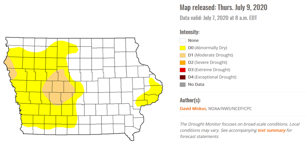
The latest drought monitor graph.
While parts of the state are characterized as dry — Hall says there are two different ways to look at it. “In drought terminology we sometimes talk about an agricultural drought versus a hydrological drought,” he says. “And the agricultural drought comes much more quickly because those crops need moisture and they typically get it from the upper part of the soil profile.” The other type of drought impacts more long-term water needs. “For drinking water for groundwater. So, we’re concerned and we are watching it, but right now the impacts are primarily agricultural. But if things don’t improve, then we’ll start to see those impacts move into other parts of the system,” Hall says.
He says not all rain will help get rid of the dry conditions. Hall says we often get thunderstorms this time of year that dump big amounts of rain and that tends to run off the ground quickly, and is not as helpful to crops. He says a slow, steady rain would be the most helpful right now. Hall says the longer the drought continues, the more you have to worry about the time it takes to come out of it. “Drought conditions typically are a long time building up — they don’t come generally very quickly. And on the other side of the coin — to move a drought out of the state doesn’t come in one rainstorm — typically it takes a prolonged period of wet weather,” according to Hall.
Hall says the rains can also be sporadic this time of year and help one area agriculturally — while leaving another area still in need of rain.
Area Counties: Dallas and Madison…HEAT ADVISORY IN EFFECT FROM NOON TODAY TO 8 PM CDT THIS EVENING…
* WHAT…Heat index values from 100 to 105 expected.
* IMPACTS…Hot temperatures and high humidity may cause heat illnesses to occur.
PRECAUTIONARY/PREPAREDNESS ACTIONS…
Drink plenty of fluids, stay in an air-conditioned room, stay out of the sun, and check up on relatives and neighbors. Young children and pets should never be left unattended in vehicles
under any circumstances. Take extra precautions if you work or spend time outside. When possible reschedule strenuous activities to early morning or evening. Know the signs and symptoms of heat exhaustion and heat stroke. Wear lightweight and loose fitting clothing when possible. To reduce risk during outdoor work, the Occupational Safety and Health Administration recommends scheduling frequent rest breaks in shaded or air conditioned environments. Anyone overcome by heat should be moved to a cool and shaded location.
Heat stroke is an emergency! Call 9 1 1.
The National Weather Service in Des Moines says the hottest day of the week for Iowa can be expected on Wednesday. Officials say temperatures in the 90’s with heat index values of 100º to 105º are likely. 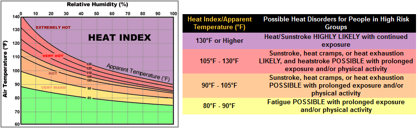 They recommend if you have to be outdoors for an extended period of time, take frequent breaks in the shade & drink plenty of fluids. The young and elderly and those with medical conditions should use extra caution outdoors.
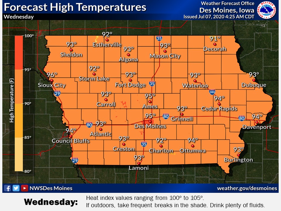
Special Weather Statement
National Weather Service Omaha/Valley NE
204 AM CDT Sun Jul 5 2020
Monona-Harrison-Shelby-Pottawattamie-Mills-Montgomery-Fremont-
Page Counties…UNHEALTHY TO HAZARDOUS AIR QUALITY WILL LINGER UNTIL 9 AM ON SUNDAY…
Unhealthy to hazardous air quality has developed over much of eastern Nebraska and southwest Iowa early this morning, and these conditions will likely linger until around 9 AM. The poor air quality is the result of lingering smoke from Saturday evening fireworks activity which has become trapped near the ground by a
temperature inversion and stagnant air flow pattern. Conditions are expected to improve after 9 AM as increased atmospheric mixing allows for the dispersion of the smoke.
Those with respiratory concerns should avoid outdoor exposure until conditions improve later this morning.
The month of June in Atlantic, was warmer than normal, and much drier. Data compiled here at the KJAN Studios (The official National Weather Service reporting site for Atlantic), indicate the Average High last month was 88, which was five-degrees warmer than average. The Average Low of 64 was also five-degrees warmer than normal. Precipitation for the month, which amounted to just 1.59-inches, was 4.24 inches, more than 3.4-inches drier than normal.
For the month of July, the average High here in Atlantic is typically 86 and the Low is normally around 63. Precipitation will typically amount to nearly 4.62-inches.


