
Here is a glimpse of the latest road conditions from 511ia.org, as of 5:15-a.m., 1/15/21

404 AM CST Thu Jan 14 2021
…Blizzard Conditions Western into Central Iowa Tonight into Friday with Significant Travel Impacts Expected…
The first of two waves of wintry precipitation is moving into the state this morning with some limited impacts this morning. There will be a short dry period later this morning into a part of this afternoon before the second wave of precipitation moves into the state. Snow accompanied by strong winds will create blizzard conditions over western Iowa and toward the I-35 corridor tonight into Friday. Significant travel impacts with near impossible travel at times later tonight into Friday is expected. Snow will end Friday night, but travel impacts will linger.
Audubon-Guthrie-Dallas-Cass-Adair-Madison-Adams-Union-Taylor-Ringgold-Pottawattmie-Mills-Montgomery & Page Counties.…WIND ADVISORY NOW IN EFFECT UNTIL MIDNIGHT CST TONIGHT…
* WHAT…Northwest winds 20 to 30 mph with gusts up to 45 mph.
* IMPACTS…Gusty winds could blow around unsecured objects. Tree
limbs could be blown down and a few power outages may result.
Guthrie-Dallas-Cass-Adair-Madison-Adams-Union-Taylor-Ringgold-Monona-Harrison-Shelby-Pottawattamie-Mills-Montgomery-Fremont-Page Counties..BLIZZARD WARNING IN EFFECT FROM MIDNIGHT TONIGHT TO 6 PM CST FRIDAY…
* WHAT…Blizzard conditions expected. Total snow accumulations of 3 to 5 inches. Winds gusting as high as 45 mph.
* IMPACTS…Travel could be very difficult if not impossible at
times with blowing snow significantly reducing visibility. The
hazardous conditions will impact the Friday morning and evening
commutes. Isolated power outages and tree damage may occur with
the gusty winds.
PRECAUTIONARY/PREPAREDNESS ACTIONS…
Travel should be restricted to emergencies only. If you must
travel, have a winter survival kit with you. If you get stranded,
stay with your vehicle.
The latest road conditions for the state you are calling from can
be obtained by calling 5 1 1.
**WIND ADVISORY in effect until 12-p.m. Friday**BLIZZARD WARNING FROM MIDNIGHT TO 6-P.M. FRIDAY**
Today: Mostly cloudy w/light rain-snow. Temps nearly steady in the 30’s. NW @ 20-35 mph w/gusts to near 40. Little or no snow accumulation expected.
Tonight: Snow & patchy blowing snow. Low around 25. NW 20-35 w/gusts to near 45. Wind chill around 10. New snow accumulation of 1 to 3 inches possible.
Friday: Snow, mainly before noon. Areas of blowing snow. High near 28. W/NW @ 20-40 w/gusts to near 45. Wind chill values as low as 10. New snow accumulation of 1 to 2 inches possible.
Saturday: Partly to mostly cloudy. Scattered flurries. High near 26.
Sunday: Partly to mostly cloudy. Scattered flurries. High near 26.
Wednesday’s High in Atlantic was 44. Our Low was 32. We received .01″ rain overnight up until 5-a.m. today. Last year on this date, the High in Atlantic was 35 and the Low was 22. The Record High for Jan. 14th was 54 in 1914, and the Record Low was -29 in 1957.
Today: Partly cloudy. High 50. SW @ 10-20.
Tonight: P/Cldy to Cloudy. Low 35. S@ 5-10.
Tomorrow: Cloudy w/light rain-snow in the morning. Nearly steady temps in the 30’s. NW @ 20-35. (< than 1″ snow expected)
Friday: Mostly cloudy & windy w/snow-flurries. High 37. N/NW @ 20-35 mph.
Saturday: Mo. Cldy. High 26.
Tuesday’s High in Atlantic was 45. Our Low was 19. Last year on this date, the High in Atlantic was 34, and the Low was 25. The All-Time Record High here on this date was 62 in 1987, and the Record Low was -24 in 1916.
Today: Partly cloudy. High 48. SW @ 10-20.
Tonight: Partly cloudy. Low 28. SW @ 5-10.
Tomorrow: P/Cldy. High 54. SW @ 15-25.
Thursday: Mostly cloudy & windy w/light rain-snow. High 36. NW @ 15-30 (Little or no snow accumulation expected)
Friday: Mo. Cldy & windy w/a chance of flurries. High around 27.
Monday’s High in Atlantic was 40. Our Low this morning, 21. Last year on this date, the High in Atlantic was 27, and the Low was 16. The All-Time Record High here on this date was 57 in 1961 & 1987, and the Record Low was -37 in 1974.
Today: Becoming partly cloudy. High near 38. SW @ 10-15.
Tonight: Partly cloudy, with a low around 22. SW @ 5-10.
Tuesday: P/Cldy. High around 45. W/SW @ 10-15.
Wednesday: P/Cldy. High near 50.
Thursday: Mo. Cldy & windy w/a chance of flurries. High around 34.
Sunday’s High in Atlantic was 33. Our Low this morning, 25. Last year on this date, the High in Atlantic was 23, and the Low was 5. The All-Time Record High here on this date was 55 in 1986, and the Record Low was -22 in 1892.
(Updated 4:50-a.m.)
Today: Areas of fog between 8am and 11am. Otherwise, cloudy, with a high near 29. Calm wind becoming northwest around 6 mph in the afternoon.
Tonight: Mostly cloudy, with a low around 20. Calm wind becoming southwest around 6 mph after midnight.
Monday: Mostly sunny, with a high near 38. Southwest wind 6 to 13 mph, with gusts as high as 20 mph.
Monday Night: Partly cloudy, with a low around 19. Southwest wind 5 to 9 mph becoming light west after midnight.
Tuesday: Mostly sunny, with a high near 40. Calm wind becoming west 5 to 7 mph in the afternoon.
Wednesday: Partly sunny, with a high near 43.
Saturday’s High in Atlantic was 26. Our Low was 21. Last year on this date the High in Atlantic was 26 and Low 5. The Record High on this date was 59 in 1928. The Record Low was -27, in 1982.
Officials with the National Weather Service report the August, 2020 derecho which heavily impacted Iowa and four other Midwestern states, was only outdone by Hurricane Laura and the collective Western Wildfires in terms of estimated cost.The data compiled by NOAA (the National Oceanic and Atmospheric Administration), shows the Derecho racked-up $11 Billion in damage. The August 10th event began in southeast South Dakota and swept through to Ohio – a 770 mile trip – in a span of just 14 hours, with widespread wind gusts greater than 100 miles per hour. Four people died as a result of the weather phenomenon.
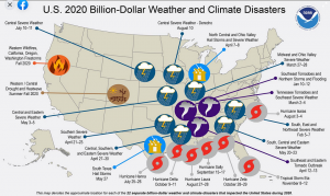 Iowa, Illinois, Minnesota, Indiana and Ohio were the states most affected by the event that caused millions of dollars damage to acres of corn and soybeans across central Iowa. There was also severe damage to homes, businesses and vehicles, particularly in Cedar Rapids. In addition, there were 15 tornadoes across northeastern Illinois, affecting the Chicago metropolitan area. Officials say it was the third severe weather event (since 1980) with inflation-adjusted costs over $10-billion, joining the late-April and May 2011 tornado outbreaks across the Southeastern and Central states, respectively.
The number one weather event, in terms of cost, was the August-27th/28th impact of a Category 4 Hurricane named “Laura,” which hit southwest Louisiana with winds of up to 150 mph and a storm surge of more than 15 feet. It was the strongest hurricane to hit Louisiana since 1856, and cost $19-billion.The Weather Service said 46 people died during the event. The second costliest weather event, was the Western Wildfires affecting California, Oregon and Washington State. A total of 46 people died. Colorado also had historic levels of fire damage. The flames raged across more than 10.2-million acres from August 1st through December 30th, costing an estimated $16.5-billion in damage.
Number four on the list, was Hurricane Sally, a CAT 2 hurricane taking place from Sept. 15th to 17th, and which made landfall in Gulf Shores, Alabama. Altogether it caused an estimated $7.3-billion damage, and resulted in five persons dead.
Today: Areas of fog this morning; Partly-to Mostly- cloudy. High 34. NE @ 5-10.
Tonight: P/cldy to cldy w/areas of fog. Low 20.
Tomorrow: P/Cldy to cldy w/morning fog. High 33. N @ 5-10.
Sunday: P/Cldy to Cloudy. High 33.
Monday: P/Cldy. High 38.
Tuesday’s High in Atlantic was 33. Our Low was 20. Last year on this date the High in Atlantic was 43 and Low 15. The Record High on this date was 65 in 2003. The Record Low was -19, in 1970.
(Updated 4:45-a.m.)
OMAHA, Neb. (AP) — The risk for flooding along the Missouri River appears lower than normal headed into the year because the ground remains dry across most of the region and snowpack levels are generally below average. Officials with the Corps of Engineers and National Weather Service caution that it is still early in the year and conditions can change.
But currently it appears that 2021 will be somewhat drier and only about 90% of the normal amount of water is expected to flow down the Missouri River. That is welcome news for areas along the river where levees damaged during 2019’s flooding are still waiting to be repaired.


