
Today: Areas of fog this morning, otherwise partly cloudy. High 81. S @ 5-10.
Tonight: Fair to P/Cldy. Low 56. Winds light & variable.
Tomorrow: P/Cldy. High 83. SW @ 5-10.
Friday: P/Cloudy. High around 86.
Saturday: P/Cldy. High 88.
Tuesday’s High in Atlantic was 79. Our Low this morning, 50. Last year on this date the High in Atlantic was 92 and the Low was 68. The Record High on this date was 100 in 1934. The Record Low was 36 in 1907.
The month of May in Atlantic was cooler and drier than normal. Weather data compiled here at the KJAN Studios (The official National Weather Service reporting site), show the Average High last month (rounded-off) was 71 (70.8), compared to the normal average high of 73. Our Average Low in May was 48 (47.5), which was just one-degree cooler than normal. We broke the old record Low of 29 degrees on May 5th, when the thermometer bottomed-out at 28. The day before (May 4th) was the coldest day of the month, with a Low of 27, but it was not a record-breaker.
We received 2.65 inches of rain last month, which was nearly 1.7 inches (1.67″) below the normal 4.32 inches for May. Looking ahead to the month of June, here in Atlantic, we can expected an Average High of 82-degrees, an Average Low of 58, and rain typically amounting to 4.98-inches. We’ll let you know how the data compared to the norm, July 1st.
Today: Areas of dense fog this morning; Becoming Partly sunny. High around 76. S @ 5-10.
Tonight: Fair to P/Cldy. Low 52. Winds light & variable.
Tomorrow: P/Cldy. High 79. S @ 5-10.
Thursday: P/Cloudy. High around 82.
Friday: P/Cldy. High 85.
Monday’s High in Atlantic was 77. Our Low was 49. Last year on this date the High in Atlantic was 89 and the Low was 68. The Record High on this date was 99 in 1934. The Record Low was 36 in 1956.
Today (Memorial Day): Areas of fog this morning; Partly cloudy to cloudy w/scattered showers possible. High near 70. S @ 5-10.
Tonight: Cloudy to P/Cldy. Low around 48.
Tomorrow: P/Cldy w/isolated showers possible. High near 72. SE @ 10.
Wednesday: P/Cloudy. High around 74.
Thursday: P/Cldy. High 77.
Sunday’s High in Atlantic was 64. Our Low this morning, 45. We had just a few sprinkles of rain Sunday. Last year on this date, the High in Atlantic was 74 and the Low was 60. The Record High was 101 in 1934. The Record Low was 31, in 1897.
Today: A 30 percent chance of showers, mainly after 1pm. Cloudy, with a high near 64. South wind 5 to 7 mph. New precipitation amounts of less than a tenth of an inch possible.
Tonight: Cloudy, then gradually becoming partly cloudy, with a low around 48. South southwest wind around 6 mph becoming calm in the evening.
Memorial Day: Partly sunny, with a high near 72. Calm wind becoming south southwest around 5 mph in the afternoon.
Monday Night: Partly cloudy, with a low around 50. South wind around 5 mph becoming calm in the evening.
Tuesday: A 20 percent chance of showers after 1pm. Mostly sunny, with a high near 73. Calm wind becoming southeast 5 to 7 mph in the morning.
Wednesday: A 20 percent chance of showers and thunderstorms after 1pm. Mostly sunny, with a high near 76.
Saturday’s High in Atlantic was 66. Our Low was 38. Last year on this date, the High in Atlantic was 64 and the Low was 52. The Record High was 105 in 1934. The Record Low was 33, in 1930.
Today: Areas of fog this morning; Mostly sunny. High 67. SE @ 10.
Tonight: Fair to partly cloudy. Low 44. SE @ 5.
Tomorrow: P/Cloudy to Cloudy w/a chance of afternoon showers. High 65. S @ 10.
Monday (Memorial Day): P/cldy to cldy w/a chance of showers in the morning. High 68.
Tuesday: P/Cldy. High 72.
Friday’s High in Atlantic was 52. Our Low this morning was 37. Last year on this date, the High in Atlantic was 76 and the Low was 48. The Record High was 104 in 1934. The Record Low was 29, in 1947.
Today: Mostly cloudy w/areas of drizzle this morning. High 59. N @ 10-20.
Tonight: Clearing skies & diminishing winds. Low 35.
Tomorrow: Mostly sunny. High 68. E @ 5-10.
Sunday: Mo. Cloudy. High 66.
Monday (Memorial Day): Mo. Cldy w/a chance of rain. High 68.
Thursday’s High in Atlantic was 73. Our Low this morning (as of 4:55-a.m.,) was 45. We received a trace of precipitation this morning, in the form of drizzle. Last year on this date, the High in Atlantic was 81 and the Low was 47. The Record High was 97 in 2018. The Record Low was 29, in 1894.
KJAN Studios- 0.94″
7.1 NNW of Atlantic- .85″
Massena- .54″
Schleswig- .36″
Adel- .23″
Persia- .82″
Mondamin- 1.15″
Missouri Valley- 1.04″
Earlham- .23″
Pacific Junction- 1.41″
Des Moines- .28″
Council Bluffs- .87″
Kirkman- .54″
Corydon- .12″
Churdan- .35″
Today: Showers and thunderstorms (mainly this morning). High 68. SE winds becoming N @ 10-20. New rainfall amounts between a quarter and half of an inch possible.
Tonight: Partly cloudy to cloudy w/scattered showers possible. Low around 43. NW @ 10-20. Chance of precipitation is 30%. New precipitation amounts of less than a tenth of an inch possible.
Tomorrow: P/Cldy to Cldy. High near 60. NW @ 10-20.
Saturday: Sunny, with a high near 68.
Sunday: Mo. Cldy. High around 68. Memorial Day (Monday): Mo. Cldy w/a chance of showers. High 66.
Wednesday’s High in Atlantic was 84. Our Low was 54. Rainfall overnight amounted to .94″. Last year on this date, the High in Atlantic was 77 and the Low was 63. The Record High for May 27th was 100 in 2018. The Record Low was 31 in 1907.
There is a slight risk for severe storms overnight in southwest Iowa. The main threats will be from winds and hail. Locally heavy rainfall will also be possible.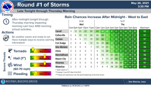
There is a slight risk of severe storms is in south central and southeast Iowa on Thursday into Thursday night. A marginal risk exists to the north across much of central Iowa, except for northern Iowa. Main concerns are from wind and hail. A tornado is possible too.
The threat of locally heavy rain continues into Thursday as well. A few thunderstorms remain possible late Sunday into Tuesday in central and western Iowa. Severe weather appears unlikely at this time.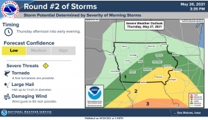
SPOTTER INFORMATION STATEMENT… Spotter activation may be needed late tonight and Thursday.


