
Today: Partly sunny, with a high near 90. N @ 10-15 mph.
Tonight: P/Cldy. Low around 60. Light & variable breeze.
Tomorrow: Mostly Sunny, with a high near 87. E/Se @ 5-10.
Wednesday: P/Cldy. High around 88.
Thursday: P/Cldy w/a chance of showers and thunderstorms. High around 92.
Sunday’s High in Atlantic was 94. Our Low was 55. Last year on this date the High was 86 and the Low was 62. The Record High on June 14th in Atlantic, was 97 in 1987, and the Record Low was 41 in 1933.
Today: Sunny, with a high near 91. Calm wind becoming southwest 5 to 8 mph in the afternoon.
Tonight: Mostly clear, with a low around 63. West southwest wind 5 to 7 mph becoming light and variable after midnight.
Monday: Mostly sunny, with a high near 89. Calm wind becoming east northeast 5 to 7 mph in the morning.
Tuesday: Sunny, with a high near 89. Calm wind becoming east northeast around 6 mph in the afternoon.
Wednesday: Sunny, with a high near 90.
Skyscan Forecast Saturday, June 12, 2021 Dan Hicks
Today: Mostly sunny. Less humid. N @ 10. High 87.
Tonight: Fair to partly cloudy. Light and variable winds. Low 53.
Sunday: Partly cloudy. Winds variable 5-10. High 89.
Sunday Night: Clear. Calm. Low 63.
Monday: Partly cloudy. High 87.
Tuesday: Partly cloudy. High 89.
Yesterday’s high at the KJAN studios was 85 and the low this morning was 62. We picked up .2″ of rainfall at the studios. This day last year the high was 90 and the low was 55. All-time record high for today’s date is 95 set in 1892 and the low 38 set in 1903. Sunrise this morning is 5:45 a.m. and sunset is 8:54 p.m.
A Severe Thunderstorm Watch that was in effect until 11:30-a.m., for Monona, Harrison, Pottawattamie and Shelby Counties, was cancelled at 11:15-a.m. There were no reports of damage. A SEVERE THUNDERSTORM WATCH remains in effect for the far southwest corner counties of Iowa, until 3:00-p.m. (Mills, Montgomery, Fremont and Page Counties).
THE NATIONAL WEATHER SERVICE HAS EXTENDED SEVERE THUNDERSTORM WATCH 257 TO INCLUDE THE FOLLOWING AREAS IN IOWA:
HARRISON POTTAWATTAMIE SHELBY MONONA. The Main threat is damaging winds. 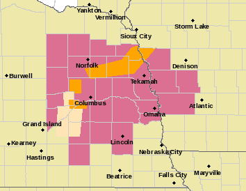
(Radio Iowa) – The new U-S Drought Monitor map shows 90 percent of Iowa is experiencing some type of dryness or drought. The Iowa D-N-R’s Tim Hall says only one section of the state has not water worries. “Southeastern Iowa way down in the corner — they’re not showing any dryness or drought — but virtually the rest of the state is,” Hall says. The area of concern in northwest Iowa has grown a little bit. So, certainly the conditions are not trending in the direction we’d like to see them.
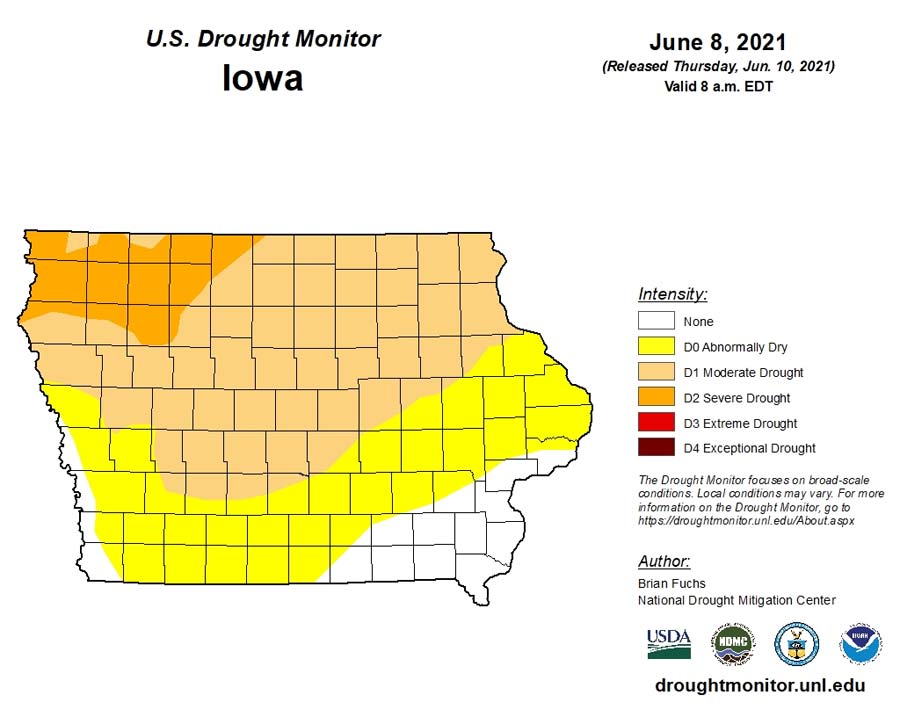 The map shows 32 percent of the state rated as abnormally dry, 47 percent rated as in moderate drought and 10 percent rated as severe drought. Hall says streamflow conditions across approximately half of the state are now classified as “below normal.” He says the dry conditions in the north are now impacting things downstream. “As that lack of runoff works its way down through the system, we are seeing that reflected in the watersheds that run through central Iowa,” according to Hall. “So even though we may not be a dry here as in some parts of the state. The parts that feed those river systems have been exceptionally dry, so we are starting to see very low stream levels in parts of the state.”
Hall says the dry weather is worse this year because there wasn’t much moisture in the reserve. “Last year we entered 2000, we entered the growing season with a significant supply of groundwater and soil moisture leftover from 2018 and ’19, which were really wet years. He says. “This year — 2021 — we came into the year with almost no excess soil moisture and groundwater. So, it’s as if we started with an empty tank.” Hall says the weather data for June, July and August show there is a chance to run things around. “Over that three-month period statewide we average right at about an inch per week of rainfall. And that’s a pretty hefty chunk of moisture,” Hall says. “If we were able to get normal rainfall for the next three months — I think we would be in pretty good shape. The challenge is, every week that goes by without rain puts us another inch behind.”
He says you always have to wait and see with the weather. “We’re not panicking yet. But we’d really like to see some rain here in the month of June to start to replenish some of the soil moisture and start to get us back on track,” Hall says. Some cities are asking residents to be smart about their water use as the dry conditions continue. Hall says those measures may be ramped up more if the lack of rainfall continues.
Today: Partly Cloudy to Cloudy, w/scattered showers & thunderstorms. High 88. S @ 10-15 mph.
Tonight: Rain ending, becoming Partly cloudy. Low 64. NW @ 5-10.
Tomorrow: P/Cldy. High 87. N @ 5-10.
Sunday: P/Cldy. High 89.
Monday: P/Cldy. High near 90.
Thursday’s High in Atlantic was 96. Our Low was 68. Last year on this date the High in Atlantic was 86 and the Low was 52. The Record High on this date was 99 in 1892. The Record Low was 36 in 1903.
Today: Party-to Mostly Sunny. High 94. S @ 10-15 mph.
Tonight: Partly cloudy. Low 70. S @ 5-10.
Tomorrow: P/Cldy to cldy w/scattered showers & thunderstorms. High around 86. S winds shifting to the N @ 10-15.
Saturday: P/Cldy. High 88.
Sunday: P/Cldy. High 89.
Wednesday’s High in Atlantic was 94. Our Low this morning, 66. Last year on this date, the High was 75 and the Low was 56. The Record High was 104 in 1933, and the Record Low was 40 in 1966.
(Radio Iowa) – Drought conditions are expected to expand and worsen across Iowa when the new map is released tomorrow (Thursday) from the U-S Drought Monitor. The continued hot, dry weather is being reflected in runoff predictions for the Missouri River. Kevin Grode, with the U-S Army Corps of Engineers in Omaha, says lower-than-normal runoff has persisted since last year.
“May runoff above Sioux City, Iowa, was 2.1 million acre feet, which is 61-percent of average,” Grode says. “This follows a very dry April. Soil conditions in the upper basin continue to be extremely dry during the mountain snowmelt and spring rainfall portion of the runoff season.” Grode says the Corps’ overall runoff prediction will end up well below normal.
“The current dry soil conditions and NOAA’s latest outlooks calling for warmer-than-normal temperatures and drier-than-normal precipitation has resulted in the 2021 calendar year runoff forecast of 17.9-million acre feet, which is 69-percent of average,” he says. Grode says they don’t expect much change until perhaps 2022.
“Given the dry soil moisture conditions, below average stream flow and the extended warm and dry climate outlook, we expect runoff to remain below average during the remainder of the calendar year,” Grode says. The Corps is sending letters to water users all along the river, warning them of possible problems with low water access.
Today: Mostly sunny this morning; P/Cldy this afternoon. High near 90. SE @ 10-15 mph.
Tonight: Fair to Partly cloudy. Low around 66. SE @ 5.
Tomorrow: Mostly sunny. High 92. S @ 10-15.
Friday: P/Cldy to cldy w/scattered showers & thunderstorms. High around 86.
Saturday: P/Cldy. High 88.
Tuesday’s High in Atlantic was 91. Our Low this morning, 64. Last year on this date, the High was 89 and the Low was 57. The Record High was 101 in 1985, and the Record Low was 38 in 1915.


