
Several areas of Cass County received hail Friday night into early Saturday morning. The hail ranged in size from dimes to larger than golf balls. In Atlantic, hail fell at the KJAN Studios at around 11:30-p.m. Power was lost in the Massena area and south for a brief time. The Cass County Sheriff’s Department said Deputies noticed utility crews out and about during and after the storm.
The Montgomery County Emergency Management Agency posted pictures of the hail on their Facebook page. The National Weather Service in Des Moines began posting Severe Thunderstorm Warnings for parts of Union and Madison Counties at around 10-p.m.
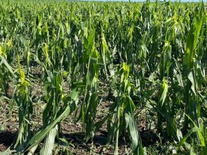
Crop damage in Montgomery County (Via the Montgomery EMA’s Facebook page)
 The storm cells began to back fill and pop-up to the west, into Cass, Adams, Mills, Montgomery and Pottawattamie Counties, and then pushed eastward at speeds of 30-to 40-mph.

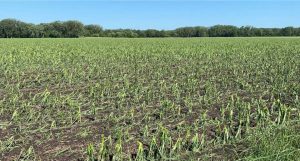
Montgomery County EMA photo
The National Weather Service in Des Moines and Valley Nebraska, shared social media images of three-inch diameter hail that fell in Lorimor in Union County at around 10:40-p.m., Friday. Irregular hail up to four-inches in diameter fell in and around Bridgewater. Golf-ball size hail was reported near Orient in Adair County, at around 10:05-p.m.

NWS social media shared post of hail near Lorimor
Other reports include:

Hail that fell near Oakland and Carson (NWS/Omaha photo)
Today: Partly Cloudy w/isolated showers this morning. High around 90. N @ 5-10.
Tonight: P/Cldy w/isolated showers & thunderstorms late. Low 65.
Tomorrow: P/Cldy. High 88. N @ 5-10.
Saturday Night: A 50 percent chance of showers and thunderstorms. Low around 67.
Sunday: P/Cldy w/ scattered showers & tstorms. High near 90. Breezy.
Monday: P/Cldy & cooler. High around 78.
Thursday’s High in Atlantic of 102 tied the record of 102 first set in 1918. Our low was 69. Last year on this date, the High was 91 and the Low was 66. The Record High in Atlantic on June 18th was 98 in 1910, and the Record Low was 46 in 1974 & 2000.
(Radio Iowa) – The new map from the U-S Drought Monitor shows worsening conditions across Iowa. Only five percent of the state is shown as having normal conditions, all in the southeast, while drought gained more ground practically everywhere else. Parts of eastern and far southwestern Iowa are in the abnormally dry category, but the majority of the state’s in drought.
A week ago, 56-percent of Iowa was in moderate to severe drought, now, it’s 76-percent. Severe drought covers about 40 of the state’s 99 counties, including virtually all of northern Iowa and much of the central region.
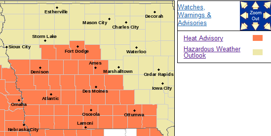
A heat advisory is posted for much of the state today (Thursday), as highs are forecast to reach the upper 90s to around 100 degrees, with heat indices in southwest Iowa climbing to 107.
The first severe thunderstorm warnings in June were issued for the KJAN listening area, Wednesday night. The National Weather Service issued a Severe Thunderstorm Watch at around 10-p.m., and less than 30-minutes later issued a Severe Thunderstorm Warning, for Audubon and Guthrie Counties. The Weather Service says at around 10:17-p.m., thunderstorm wind damage was reported in Templeton, where tree branches ranging in size from 2-to 6-inches in diameter were snapped, and a flag pole was blown over.
At around 10:32-p.m., thunderstorm winds knocked a tree and blocking Highway 141, two miles northwest of Manila. A personal weather station six-miles west of Gray recorded a wind gust of 60-miles per hour at around 10:19-p.m. Another personal weather station reported a 62-mile per hour wind gust two miles south of Willey, in Carroll County, and a 59-mile per hour wind gust two miles northwest of Carroll.
(See the latest storm damage reports at https://forecast.weather.gov/product.php?site=DMX&issuedby=DMX&product=LSR&format=CI&version=1&glossary=1)
Today: **Heat Advisory in effect from 1-pm until 8-pm**Scattered showers & thunderstorms ending this morning; Becoming partly-to-mostly sunny. High 97. Winds 10-20 mph.
Tonight: P/cldy w/scattered showers & thunderstorms redeveloping late. Low around 70. Winds variable @ 5-10 mph.
Tomorrow: Showers & tstrms early, then P/cldy. NE winds 5-10. High 88.
Saturday: P/cldy. High 88.
Sunday: P/Cldy to Cldy w/scatt. shwrs & tstrms. High again around 88.
Wednesday’s High in Atlantic was 93. Our Low was 65. Rainfall in Atlantic overnight amounted to .34″ at the KJAN Studios. Last year on this date the High in Atlantic was 89 and the Low was 68. The Record High on this date was 102 in 1918. The Record Low was 40 in 1974.
424 PM CDT Wed Jun 16 2021 …A HEAT ADVISORY IS IN EFFECT FROM 1 PM TO 8 PM CDT THURSDAY FOR ALL OF SOUTHWEST, MUCH OF WEST CENTRAL AND SOUTHERN IOWA…
 PRECAUTIONARY/PREPAREDNESS ACTIONS… Drink plenty of fluids, stay in an air-conditioned room, stay out of the sun, and check up on relatives and neighbors. Young children and pets should never be left unattended in vehicles under any circumstances. Take extra precautions if you work or spend time outside. When possible reschedule strenuous activities to early morning or evening. Know the signs and symptoms of heat exhaustion and heat stroke. Wear lightweight and loose fitting clothing when possible.
To reduce risk during outdoor work, the Occupational Safety and Health Administration recommends scheduling frequent rest breaks in shaded or air conditioned environments. Anyone overcome by heat should be moved to a cool and shaded location. Heat stroke is an emergency! Call 9 1 1.
Today: Isolated showers & thunderstorms this morning, otherwise party cloudy. High 92. SE @ 10-15 mph.
Tonight: Osolated showers and thunderstorms possible, otherwise P/cldy. Low around 70. SE @ 5-10.
Tomorrow: P/Cldy w/isolated morning showers/thunderstorms possible. High 96. SW @ 10-20.
Friday: Isolated showers & thunderstorms possible early. High 88. A
Saturday: P/cldy. High 86.
Tuesday’s High in Atlantic was 92. Our Low this morning, 57. Last year on this date the High was 91 and the Low was 67. The Record High was 103 in 1946 and the Record Low was 42 in 1974.
Today: Partly-to-Mostly sunny, with a high near 90. NE @ 10-15 mph.
Tonight: P/Cldy. Low around 62. E @ 5.
Tomorrow: P/Cldy. High around 90. SE @ 10-15.
Thursday: A chance of showers & thunderstorms early; then P/Cldy. High around 94.
Friday: A chance of showers and thunderstorms in the morning; P/Cldy. High 86.
Monday’s High in Atlantic was 92. Our Low this morning, was 55. Last year on this date the High was 91 and the Low was 69. The Record High on June 15th in Atlantic, was 99 in 1918, and the Record Low was 40 in 1906 & 1969.
(Radio Iowa) – High temperatures in the southwestern U-S are forecast to climb as high as 118 degrees over the next few days and there are fears that extreme heat could expand into the Midwest. Meteorologist Dennis Todey, director of the U-S-D-A’s Midwest Climate Hub in Ames, says he’s concerned Iowa’s drought conditions will continue to worsen. “The Southwest right now, because of the dry conditions, that tends to reinforce that dome of high pressure,” Todey says. “There are hints in the models about it sticking that way but the models aren’t consistent of saying that’s going to be the case and it’s definitely going to move over you folks.”
Forecasters are calling for warmer-than-normal highs this week across Iowa, again, in the 80s and 90s with little chance for rain. Summer starts this coming weekend so we’re heading into the hot months. “By the time we reach mid-June, we’re worried about average precipitation and precipitation starts to fall off, climatologically,” Todey says. “We still have warm periods ahead of us, so it still has me concerned.”

Dennis Todey
The computer forecast models are still not providing a clear picture of what may lie ahead. “Does it kind of break down a little bit and as we say warmer-than-average and cooler-than-average bouncing back and forth or does it lock in?” Todey says. “Right now, we haven’t seen it lock in just yet so we’re being optimistic but there’s not good indicators on this overall, other than what we can see in the six- to ten- to 14-day outlooks.”
The latest drought monitor shows about 90-percent of Iowa is in abnormally dry or drought conditions, with more than half the state under moderate to severe drought.


