
Today: Partly cloudy to mostly cloudy skies. Scattered showers and thunderstorms this morning with some redeveloping mid to late afternoon. E @ 10 High 75
Tonight: Mostly cloudy with showers and thunderstorms. N @ 10-15 Low 62
Sunday: Mostly cloudy with a few showers in the morning. N 10-15 High 77
Monday: Partly cloudy skies High 81
Tuesday: Partly cloudy skies. High 83
WOODWARD, Iowa – (July 9, 2021) – A powerful storm that moved through Mitigwa Scout Reservation near Woodward Friday prompted camp staff to declare a weather emergency and, for the first time, Scouts and leaders took shelter in new storm shelters installed following last year’s derecho. As the storm approached, camp staff activated the emergency weather safety plan, directing all on the property to take immediate shelter in one of seven concrete-fortified storm shelters throughout Mitigwa. More than 200 people sought refuge in the emergency shelters. The shelters were completed last month just before Mitigwa began its 99th continuous summer camp program.
“This was a dangerous storm that produced damaging winds and large hail,” Matt Hill, Mid-Iowa Council CEO said. “We’re very thankful for these new shelters and that no one was hurt.” The camp staff are assessing buildings and trees for damage at the 460-acre Scout camp. The August 10, 2020, derecho, which struck eight days after the last group of boys and girls left for the season, caused millions in damage to camp facilities and destroyed countless trees. Since then, Mid-Iowa Council built the seven storm shelters, replaced damaged roofs on dozens of buildings, cleared tons of fallen trees and branches and replaced the camp’s shooting range, which was destroyed.

Mitigwa storm 7.9.2021

Mitigwa Hail, 7/9/21
While the council funded the repairs through its post-derecho “Mitigwa Strong” fundraising campaign, it is still $672,000 dollars short of its fundraising goal, which includes adding more storm shelters, renovating, or replacing many camp facilities and replanting lost trees. “We hoped we wouldn’t have to use these new shelters, much less so quickly,” Hill said. “We can’t thank people enough for supporting us in our efforts to protect Scouts, families and staff who are here to enjoy a summer camp experience. Most importantly, all campers at Mitigwa are safe and sound thanks to these shelters.”
For more information about rebuilding Mitigwa contact Grant Reigelman, Director of Support Service, 515-266-2135 or Grant.Reigelman@scouting.org. To donate to the Mitigwa Strong fund visit CampIowa.org/MitigwaStrong
**************
About Mid-Iowa Council, BSA Mid-Iowa Council serves more than 10,000 youth and families in 27 Iowa counties. The council supports programs for youth and Scout units that build character, train in the responsibilities of participating citizenship, and develop physical and mental fitness. ScoutingIowa.org
About Boy Scouts of America The Boy Scouts of America provides the nation’s foremost youth programs of character development and values-based leadership training, helping young people be “Prepared. For Life.” Scouting.org
TODAY: Thunderstorms are forecast at times today through tonight. There is a potential for severe weather at times, especially over the southern half or so of Iowa from mid-afternoon through this evening when all modes of severe weather may be possible including damaging winds, very large hail, and even tornadoes. Locally heavy rainfall is also expected, especially south of Interstate 80.
SATURDAY through Thursday: Periodic chances for thunderstorms remain in the forecast from Saturday into next week, however the threat of severe weather appears low at this time.
SPOTTER INFORMATION STATEMENT…
Spotter activation may be needed this afternoon and evening, mainly across the southern half or so of Iowa.
Today: Cloudy to Partly Cloudy w/scattered showers & thunderstorms (mainly this morning). High around 86. S/SE winds 10-20.
Tonight: P/Cldy to Cldy w/scattered showers and thunderstorms. Low around 68.
Tomorrow: Scattered showers and thunderstorms. High near 77. Wind N @ 10.
Sunday: Showers and thunderstorms in the morning. High around 75.
Monday: P/Cldy w/a high of 81.
Thursday’s High in Atlantic was 76. Our Low was 57. Rainfall Thursday and early today (up until 7-a.m./24-hours) amounted to .18″. Last year on this date the High in Atlantic was 84 and the Low was 56. The Record High on this date was 104 in 1930. The Record Low was 37 in 1895.
(Radio Iowa) – Recent rains have helped with dry conditions — but they have been spread out and some areas of the state could use much more rain. The Iowa D-N-R’s Tim Hall says severe drought conditions expanded in June from 12 counties in northwest Iowa across nearly all of northern Iowa. “Sixty-two-percent is now severe drought — up from only about eight percent at the beginning of the month,” Hall says. “So that is a significant uptick in coverage of the D-2 drought.”
While the severe drought has spread across the state — the rain we did get in June was beneficial. “June was drier than normal. Normally we get about five inches of rain. We ended up getting about three inches. That three inches of rain certainly has helped to push off any of the real severe conditions that we might otherwise be seeing right now,” according to Hall. Streamflow conditions across approximately half of the state remain in the below normal condition. Hall says other states are in worse shape coming out of June.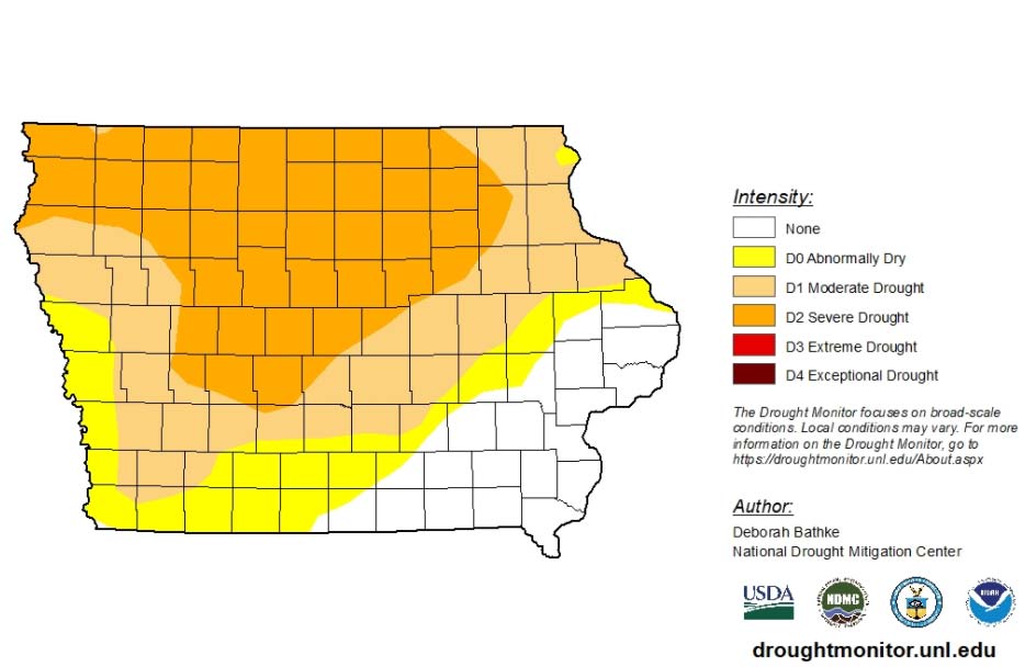
“As dry as it is in Iowa, it gets progressively worse as you go north and west into the Dakotas and Montana,” Hall says. “And the prediction in the Missouri River basin is that the runoff north of Sioux City could very well be the tenth lowest on record, going back to the late 1800s.” He says that is a big contrast to the flood fears on the Missouri River in the last couple of years.
)”The Missouri River is in as bad a shape as anything we’ve got here in the state. And it does not look like they are going to come out of that anytime real soon,” Hall says. Hall says the crops need continued moisture as they grow and there is hope we can get more rain as we move through July.
Today: Areas of fog this morning; Partly Cloudy. High 83. SE winds @ 10 mph.
Tonight: P/Cldy to cloudy w/scattered showers & thunderstorms. Low 66. SE @ 10.
Tomorrow: P/Cldy to cldy w/scatt. shwrs & strms (mainly in the morning). High 86. SE @ 10-15.
Saturday: P/Cldy to cldy w/scatt. shwrs & thunderstorms. High 80.
Sunday: Mostly cloudy. High again around 80.
Wednesday’s High in Atlantic was 76. Our Low this morning, 55. Rainfall yesterday (after 7-a.m.) amounted to .58, for a storm rainfall total of .86″. Last year on this date the High in Atlantic was 93 and the Low was 69. The Record High on this date was 102 in 1937. The Record Low was 42 in 1908.
Today: Partly Cloudy to Cloudy w/scattered showers & thunderstorms, mainly this morning. High 79. N wind @ 10 mph.
Tonight: P/Cldy. Low 60. Winds light and variable.
Tomorrow: P/Cldy. High 85. SE @ 10.
Friday: P/Cldy to cldy w/scatt. shwrs & thunderstorms. High 85.
Saturday: P/Cldy w/scatt. shwrs & tstrms. High 80.
Tuesday’s High in Atlantic was 88. Our Low this morning, 67. Rainfall overnight through 7-a.m. today, amounted to .28″. Last year on this date the High in Atlantic was 91 and the Low was 68. The Record High on this date was 107 in 1937. The Record Low was 41 in 1934.
Today: Partly Cloudy. High 93. SW winds 10-20 mph.
Tonight: P/Cldy to cloudy w/scattered late showers & thunderstorms. Low 70. S winds shifting to the NW @ 10.
Tomorrow: Scattered showers & thunderstorms, mainly in the morning. High 80. N @ 10-15 mph.
Thursday: P/Cldy. High 85.
Friday: P/Cldy w/scatt. shwrs & tstrms. High 85.
Monday’s High in Atlantic was 89. Our Low this morning, 65. Last year on this date the High in Atlantic was 91 and the Low was 65. The Record High on this date was 106 in 1937. The Record Low was 47 in 1967 & 2006.


