
(Radio Iowa) – The Climate Prediction Center of the National Weather Service is issuing a La Nina Watch for later this year. Cooler than normal Pacific Ocean surface temperatures lead to the formation of a La Nina, which can cause cooler, wetter conditions in Iowa and across much of North America. Meteorologist Doug Kluck, with the National Weather Service in Kansas City, says we just had a La Nina pattern fade away several months ago. “Two La Ninas in a row or two winters with La Nina activity or signs in the equator aren’t that unusual,” Kluck says. “Actually, it does tend to happen fairly often that you have back-to-back years of La Nina.”
Historically, La Ninas have caused below-normal temperatures across much of the Northern Plains states. An El Nino can bring weather extremes, including severe drought or severe flooding. Kluck says the last La Nina, which evaporated this past spring, didn’t have the normal impacts. “A lot of people attribute a lot of things to that and I’m not sure we can in North America,” Kluck says. “We saw last year wasn’t a typical La Nina year in terms of when it was supposed to get cold. The Northern Plains, for example, were supposed to be perhaps cooler and wetter than normal. That wasn’t the case.”
Kluck says the issuing of the watch means it’s anticipated there will be a formation of a La Nina by late fall and into winter.
(Radio Iowa) – It’s been pretty hot in Iowa in recent weeks, but our grandparents or great-grandparents might recall another sweltering summer many decades ago that was much worse. National Weather Service meteorologist Brooke Hagenhoff says you’d have to go back 85 years to find when many Iowa communities had their all-time steamiest summer. “July of 1936 is the hottest month on record,” Hagenhoff says. “In fact, there were 15 days that had temperatures over 100 degrees, including eight days straight of 100-plus-degree temperatures.” While Iowa is experiencing moderate to severe drought conditions now, we’re still not seeing anything like it was in during the Dustbowl Days of 1936.
 “Not only was it really hot, it was extremely dry,” Hagenhoff says. “In fact, only six-hundreds of an inch of rain fell during the entire month of July.” Even though Iowa has come a long way since the 1930s, with modern air conditioning in our homes and vehicles, heat remains the number-one weather killer in the state, not lightning, flooding, tornadoes or anything else. That long-ago summer was also exceptionally deadly. “By July 15th of 1936 in Iowa alone, there were over 232 fatalities due to the heat,” Hagenhoff says, “and there would be more that would occur later that summer as well.”
High temperatures for the next several days are expected to climb into the 80s and 90s for much of the state.
(Radio Iowa) – Forecasters say temperatures across much of Iowa will be climbing into the low to mid 90s for the next several days and pet owners are being reminded about what should be obvious by now. Four dogs were left in hot vehicles in Des Moines last weekend. Joe Stafford, Director of Animal Services at the Animal Rescue League of Iowa, says in one case, two dogs were trapped in a locked car at Blank Park Zoo. “It was into the low to mid 80s at the time and the inside of the car reached 109 degrees,” Stafford says. “There were two dogs left in the car by a customer of the zoo that appeared to be in distress. Luckily, the Des Moines Police Department was quick to respond.”
The owner of the vehicle was paged in the zoo but didn’t respond, so police broke out a window to rescue the animals, both of which were conscious but with very high body temperatures. Stafford says, “They just needed to be cooled down by putting them into an air-conditioned vehicle, giving them water and eventually, transporting them back to our facility so they could be checked out by our medical staff.” In the other case, two dogs were left in a vehicle at Merle Hay Mall. In addition to having broken windows, each of the owners were issued citations for neglect.
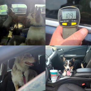
ARL photo
Leaving a window cracked open does virtually no good for cooling the passenger compartment, Stafford says, and neither does parking in the shade.
“Anything over 80 degrees, just leave your furry family members at home where they’re safe and comfortable,” Stafford says. “Take them on a car ride to the dog park or something if we’re looking to go for a car ride but just do not leave animals unattended in a vehicle.” In his 20-plus years in the industry, Stafford says he hears about cases like these every summer and he’s confounded as to why some pet owners don’t ever seem to get the message. “When your vehicle has been parked out in the sun, go get in your vehicle and try to sit in it for ten minutes,” Stafford says. “Most people will find that you’re immediately perspiring as your body is trying to keep itself cool. If you’re reacting that way, your animals are certainly going to react that way because most of them are wearing a fairly heavy fur coat.”
He urges Iowans, if you see a pet (or a child) alone in a car, call it in, as your action could save a life. For more information on summer pet safety tips: https://www.arl-iowa.org/news/pet-tips-/5-summer-heat-safety-tips-for-pets/.
Today: Partly Cloudy. High 89. S @ 5-10 mph.
Tonight: Fair to P/Cldy. Low around 66.
Tomorrow: P/Cldy. High 91. S @ 5-10.
Friday: P/Cldy. High 93.
Saturday: P/Cldy. High 93.
Tuesday’s High in Atlantic was 85. Our Low this morning, 57. Last year on this date the High in Atlantic was 86 and the Low was 59. The Record High on this date was 107 in 1934. The Record Low was 44 in 1892.
(Radio Iowa) – Forecasters say it’ll likely be dry much of this week, but last week’s heavy thunderstorms brought some areas of the state four and even five inches of rainfall. Still, overall precipitation is still well below normal in northwest Iowa. Iowa State University Extension field agronomist Joel DeJong says with corn is getting into the pollination phase and more rain would be a big help.
“Four or five inches below normal right now, yet, even after some pretty good rain since the first of July,” DeJong says. “Our timing was about perfect for the rainfall because we’re not quite at 50% silked at this stage but we’re starting to see a lot more silks on those corn plants and it is that critical time period.” DeJong says Iowa’s soybean fields will soon be entering a critical phase, too.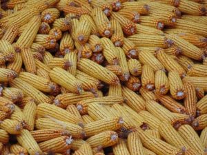
“August is much more critical for beans,” DeJong says. “It’s really nice to have some moisture now so we can really try to accelerate some of that growth and development, get those rows closed as fast as we can.” DeJong says they haven’t seen any real disease issues with the crops but bugs -are- becoming a problem for some growers.
“We’ve had some insect issues, gall midges along the edges of soybean fields,” he says, “and I’m getting several calls about corn kind of lodged, particularly on continuous corn acres that have some rootworm injury. We’re seeing beetle numbers get high in those fields so we need to watch those silks to make sure they’re not getting clipped by beetles and so we can pollinate that corn crop.”
DeJong encourages producers to scout their fields and make sure those kernels get pollinated as this is the critical time for corn.
Today: Patchy fog this morning. Partly Cloudy. High 88. Wind variable at 5-10 mph.
Tonight: Fair to P/Cldy. Low around 64.
Tomorrow: P/Cldy. High 89. S @ 5-10.
Thursday: P/Cldy. High 90.
Friday: P/Cldy. High near 93.
Monday’s High in Atlantic was 86. Our Low this morning, 59. Last year on this date the High in Atlantic was 82 and the Low was 65. The Record High on this date was 109 in 1934. The Record Low was 44 in 1953.
Today: Partly Cloudy. High 86. East wind 10 mph.
Tonight: Fair to P/Cldy. Low around 62.
Tomorrow: P/Cldy. High 87. SE @ 10.
Wednesday: P/Cldy. High 88.
Thursday: P/Cldy. High near 90.
Sunday’s High in Atlantic was 85. Our Low this morning, 58. Last year on this date the High in Atlantic was 88 and the Low was 67. The Record High on this date was 110 in 1934. The Record Low was 47 in 1981 & 1947.
Today: Widespread haze before noon, then widespread haze after 4pm. Sunny, with a high near 82. East wind 3 to 7 mph.
Tonight: A slight chance of sprinkles before 8pm. Widespread haze before 8pm. Mostly clear, with a low around 60. East wind around 6 mph becoming calm in the evening.
Monday: Mostly sunny, with a high near 83. Calm wind becoming east around 6 mph in the morning.
Monday Night: Mostly clear, with a low around 60. Light and variable wind.
Tuesday: Sunny, with a high near 86. Light and variable wind.
Tuesday Night: Partly cloudy, with a low around 62.
Wednesday: Mostly sunny, with a high near 87.
Saturday’s High in Atlantic was 83. Our Low this morning, 57. Last year on this date the High in Atlantic was 92 and the Low was 73. The Record High on this date was 107 in 1936. The Record Low was 44 in 1953.
Today: Areas of fog this morning; Partly Cloudy. High 83. E @ 5-10.
Tonight: Fair to P/Cldy. Low 63.
Tomorrow: P/Cldy. High 84. SE @ 10.
Monday: P/Cldy w/isolated showers possible. High 85.
Tuesday: P/Cldy. High 86.
Friday’s High in Atlantic was 83. Our Low was 59. Last year on this date the High in Atlantic was 93 and the Low was 70. The Record High on this date was 109 in 1936. The Record Low was 45 in 1911.
(Des Moines) – Officials with the National Weather Service in Johnston have issued a summary of the tornadic activity that occurred across Iowa, Wednesday. According to the report, supercells developed over portions of north-central Iowa on the afternoon of Wednesday, July 14, 2021. The environment was ripe for tornadic development and rotation was evident on radar shortly after storms formed. Generally south of along the Highway 20 corridor was the hot spot for tornadoes from around Nemaha, Lake City, Stanhope, Jewell, and Waverly. Tornadoes were reported around Dysart and south of Mason City. Heavy rain cause flash flooding in Maxwell and ping pong hail was reported in Clarksville.


