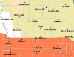
…HEAT ADVISORY IN EFFECT FROM NOON MONDAY THRU THE LATE EVENING HOURS…(9-p.m. for the far west/southwest counties; 8-p.m. for Cass & other Counties)
* WHAT…Heat index values up to 105 or higher expected.
* WHERE…Counties along and south of Interstate 80
* IMPACTS…Hot temperatures and high humidity may cause heat illnesses to occur.

Heat Advisory beginning at Noon Monday (Counties in Orange)
PRECAUTIONARY/PREPAREDNESS ACTIONS… Drink plenty of fluids, stay in an air-conditioned room, stay out of the sun, and check up on relatives and neighbors. Young children and pets should never be left unattended in vehicles under any circumstances. Take extra precautions if you work or spend time outside. When possible reschedule strenuous activities to early morning or evening. Know the signs and symptoms of heat exhaustion and heat stroke. Wear lightweight and loose fitting clothing when possible. To reduce risk during outdoor work, the Occupational Safety and Health Administration recommends scheduling frequent rest breaks in shaded or air conditioned environments. Anyone overcome by heat should be moved to a cool and shaded location. Heat stroke is an emergency! Call 9 1 1.
Today: A 20 percent chance of showers and thunderstorms before 1pm. Partly sunny, with a high near 85. South southwest wind 7 to 10 mph.
Tonight: A slight chance of showers and thunderstorms between 10pm and 11pm. Partly cloudy, with a low around 67. South wind 5 to 7 mph. Chance of precipitation is 20%.
Monday: Sunny, with a high near 93. Heat index values as high as 105. Light south southwest wind becoming south 5 to 9 mph in the morning.
Tuesday: A 40 percent chance of showers and thunderstorms after 1pm. Mostly sunny, with a high near 90. New rainfall amounts between a tenth and quarter of an inch, except higher amounts possible in thunderstorms.
Tuesday Night: A 40 percent chance of showers and thunderstorms before 1am. Partly cloudy, with a low around 63.
Wednesday: Sunny, with a high near 87.
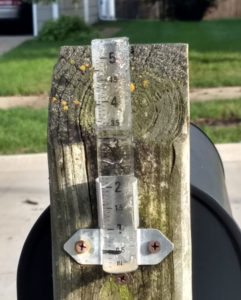
Saturday’s High in Atlantic was 84. We received .34″ rain overnight. Our Low this morning, 66. Last year on this date the High in Atlantic was 89 and the Low was 72. The Record High on this date was 111 in 1934. The Record Low was 39 in 1904.
Skyscan Forecast Saturday, August 7, 2021 Dan Hicks
Today: Partly cloudy. A few scattered morning showers, then redeveloping later in the day. S @ 10-15. High 90.
Tonight: Mostly cloudy. Scattered showers and thunderstorms. S @ 5-10. Low 70.
Sunday: Showers and thunderstorms ending in the morning. Partly cloudy. High 88.
Sunday Night: Partly cloudy. S @ 5-10. Low 65.
Monday: Partly cloudy. High 94.
Tuesday: Partly cloudy. A few isolated thunderstorms. High 90.
Yesterday’s high at the KJAN studios was 87. Last night’s low was 66. This day last year we had a high of 86 and low of 57. The all-time record high for today’s date is 103 set back in 1937. The record low was 45 set back in 1989. Sunrise today is at 6:20 a.m. Sunset will be 8:31 p.m. and Sunrise tomorrow is 6:21 a.m.
Today: A slight chance of showers & thunderstorms this morning; Becoming partly cloudy. High near 90. SW winds 10-15 mph.
Tonight: P/Cldy w/isolated showers & tstrms. Low 72. S @ 5-10.
Tomorrow: P/Cldy w/ showers ending in the morning. High near 90. SW @ 10-15.
Sunday: Scattered morning showers and thunderstorms in the morning; P/Cldy. High around 90.
Monday: P/Cldy. High 94.
Thursday’s High in Atlantic was 83. Rainfall overnight through 7-a.m. today, amounted to .03″. Our Low was 59. Last year on this date the High in Atlantic was 93 and the Low was 70. The Record High on this date was 109 in 1936. The Record Low was 45 in 1911.
(Radio Iowa) – While forecasters say Iowa’s high temperatures will be back in the 80s and 90s for the next several summer days, it’s hard to think about the foul, frigid winter that’s ahead — but we all know, it’s coming.
Peter Geiger, editor of the Farmers’ Almanac, says the 2022 edition will be out next week and its winter weather outlook for Iowa and the Midwest isn’t pretty. “It’s going to be colder than normal and in terms of the snowfall, we talk about a foot of snow January 8th through the 11th,” Geiger says. “We talk about a big blizzard on the 20th through the 23rd. I think your average in Iowa is somewhere in the 30-inch range and I think you certainly will get that.”
It’s said if you don’t like the weather in Iowa, just wait five minutes and it’ll change, and Geiger predicts there will be a lot of back-and-forth. “I think you’re going to have a fairly rough winter,” Geiger says. “We’re also saying it’s going to be a bit of a flip-flop. So what’s going to happen, as we see it, is that you’re going to get a lot of snow, then it’s going to be mild, then you’re going to get really cold, and then it’s going to be mild.”
The Farmers’ Almanac forecast is detailed and Geiger says some dedicated readers plan their calendars around it. He says “numb’s the word” as for the bone-chilling predictions in the looming winter. “We talk about a real big storm December 1st through the 4th, a real blast of Arctic frigidity with temperatures minus-20 around Christmas, then we talk about a mild beginning of January, heavy snow in the middle of January, a big storm at the end of January and then, this is the flip-flop, in February, it’s going to be cold but we don’t talk about a lot of storms,” Geiger says. “Then in March, we talk about a big storm March 4th through the 7th that will hit you and then a late season storm on April 24th to the 27th.”
That late-season storm may just be rain, not snow, he adds. While some meteorologists on TV may not be comfortable predicting the weather farther out than several days, Geiger says the Farmers’ Almanac has been working on forecasts up to 24 months out — and they’ve been doing so for more than 200 years.
“There’s a mathematical formula that was devised by our first editor, David Young back in the 1800s, because farmers needed to know about the weather,” Geiger says. “We apply sunspot activity, planet positions, the effect the Moon has on the Earth, and that allows us to do our weather two years in advance. Some weather people pooh-pooh it, but last year, when Texas had that cold spell, that was in the Almanac.”
The 2022 edition of the Farmers’ Almanac includes specifics about the many predictions it got right for the past year. Geiger admits, they don’t hit every single storm on every single date, but says if you give him a few days of leeway, it’s remarkably reliable.
Founded in 1818 and still based in Lewiston, Maine, the Farmers’ Almanac contains weather predictions for the entire four seasons of 2022 as well as all sorts of information on gardening, cooking, home remedies, folklore, managing your household, living in harmony with nature, and more.
(Radio Iowa) – Updated national maps now show there are two areas of extreme drought in Iowa. The state climatologist says the areas in northwest and east central Iowa have missed out on widespread heavier rains. According to the National Drought Mitigation Center, which produces the maps, conditions deteriorated significantly in several large patches in Iowa and Minnesota over the past week. Most of these areas have had up to six inches less than normal rainfall during the past 60 days and up to eight-and-a-half inches short of normal since early May.
All of Butler and Franklin Counties are now classified as in extreme drought, along with adjacent areas in Grundy, Hardin, Floyd, Bremer and Black Hawk Counties. In northwest Iowa, the extreme drought zone includes Dickinson, Emmett, Kossuth and Clay Counties.
Today: Partly cloudy w/scattered showers & isolated thunderstorms. High 81. S @ 5-10.
Tonight: P/Cldy. Low around 67. S @ 5-10.
Tomorrow: P/Cldy. High 90. SW @ 10-20.
Saturday: P/Cldy w/scattered shwrs & tstrms. High 88.
Sunday: Showers ending in the morning; P/Cldy, warm & humid. High in the lower 90’s.
Wednesday’s High in Atlantic was 79. Our Low was 53. We received .06″ rain overnight into early this morning. Last year on this date the High in Atlantic was 76 and the Low was 59. The Record High on this date was 1111 in 1918. The Record Low was 42 in 1978.
Today: Areas of fog this morning; Partly cloudy. High 83. SE @ 5-10.
Tonight: P/Cldy w/scattered showers. Low around 65. SE @ 5.
Tomorrow: P/Cldy w/scattered showers. High 82. S @ 10.
Friday: P/Cldy High near 90.
Saturday: P/Cldy. High again near 90.
Tuesday’s High in Atlantic was 80. Our Low this morning, 52. Last year on this date the High in Atlantic was 79 and the Low was 50. The Record High on this date was 110 in 1918. The Record Low was 38 in 1978.
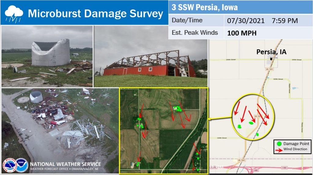
The National Weather Service in Omaha reports a severe thunderstorm caused microburst wind damage south of Persia, in Harrison County (Iowa), last Friday, July 30th. The extent of damage suggested wind speeds around 100 mph. Several grain bins and barns sustained damage from this intense but fairly narrow wind event. Most of the damage was concentrated in a 1.15 square mile area. There were no injuries reported.

(Radio Iowa) – The finals days of July saw some blast furnace-type temperatures — but State Climatologist Just Glisan says they weren’t enough to push the month above average. He says when you combine them with the below-average days — things evened out to right around the average July temperature of 74 degrees. Glisan says some two to four-inch rains in the last few days of the month gave some areas above-average precipitation. But other areas of the state missed those quenching rains. “North of I-80 and east I-35 had drier than average conditions for the month. Precipitation deficits around Waterloo and Cedar Rapids, anywhere from two to four inches below average,” Glisan says.
He says some areas just haven’t been able to make up the precipitation shortfall through the first seven months of 2021. “The driest parts of the state — basically the northeastern corner of the state — precipitation deficits anywhere from six to eight below normal. Going back a full year — and the driest part of the state is in northwestern and west-central Iowa — and those precipitation deficits approach 20 inches. So, it’s been a very dry year,” he says. 
Glisan says the dry pattern has done a total flip of the situation we had when 2018 and 2019 combined were the wettest two-year period since records have been kept. He says the calendar year temperature numbers don’t show anything unusual. Glisan says the average temperature of the first seven months never gets one or two degrees above or below the average.
Glisan says the July tornado outbreak that saw between 20 and 22 was the biggest blip on the record book — as there is an average of just seven confirmed tornadoes in the month.