
A HEAT ADVISORY CONTINUES UNTIL 8-PM for the following Counties: Cass-Adair-Adams-Union–Taylor-Ringgold-Harrison-Shelby-Pottawattamie-Mills-Montgomery-Fremont & Page.
Heat index values up to 103. Hot temperatures and high humidity may cause heat illnesses to occur.
PRECAUTIONARY/PREPAREDNESS ACTIONS… Drink plenty of fluids, stay in an air-conditioned room, stay out of the sun, and check up on relatives and neighbors. Young children and pets should never be left unattended in vehicles under any circumstances. Take extra precautions if you work or spend time outside. When possible reschedule strenuous activities to early morning or evening. Know the signs and symptoms of heat exhaustion and heat stroke. Wear lightweight and loose fitting clothing when possible. To reduce risk during outdoor work, the Occupational Safety and Health Administration recommends scheduling frequent rest breaks in shaded or air conditioned environments. Anyone overcome by heat should be moved to a cool and shaded location. Heat stroke is an emergency! Call 9 1 1.
Today: Partly Cloudy w/isolated showers & thunderstorms this morning; High 93. HEAT ADVISORY from Noon until 8-p.m.; Winds SE @ 10-15.
Tonight: P/Cldy to cldy w/scattered showers & thunderstorms. Low 73. SE @ 5-10.
Tomorrow: P/Cldy. High 94. S @ 10-15.
Saturday: P/Cldy w/scattered showers & thunderstorms late. High 94.
Sunday: P/Cldy to Cldy w/scattered morning showers & thunderstorms. High 87
Wednesday’s High in Atlantic was 94. Our Low this morning, 68. Last year on this date the High in Atlantic was 94 and the Low was 66. The Record High on this date was 100 in 1955. The Record Low was 39 in 1904.
330 AM CDT Thu Aug 26 2021
THE NATIONAL WEATHER SERVICE HAS ISSUED A HEAT ADVISORY IN EFFECT FROM NOON TO 8 PM FOR MOST COUNTIES ALONG AND SOUTH OF INTERSTATE 80 IN CENTRAL AND SOUTHERN IOWA (including Harrison, Shelby, Audubon, Guthrie, Dallas, Pottawattamie, Cass, Adair, Madison, Mills, Montgomery, Adams, Union, Fremont, Page, Taylor and Ringgold Counties). 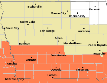
* WHAT…Heat index values up to 105 expected.
* IMPACTS…Hot temperatures and high humidity may cause heat illnesses to occur.
PRECAUTIONARY/PREPAREDNESS ACTIONS…
Drink plenty of fluids, stay in an air-conditioned room, stay out of the sun, and check up on relatives and neighbors. Young
children and pets should never be left unattended in vehicles under any circumstances.
Take extra precautions if you work or spend time outside. When possible reschedule strenuous activities to early morning or evening. Know the signs and symptoms of heat exhaustion and heat stroke. Wear lightweight and loose fitting clothing when possible. To reduce risk during outdoor work, the Occupational Safety and Health Administration recommends scheduling frequent rest breaks in shaded or air conditioned environments. Anyone overcome by heat should be moved to a cool and shaded location. Heat stroke is an emergency! Call 9 1 1.
Today: Showers ending this morning; P/Cldy. High 91. E/SE @ 5-10.
Tonight: P/Cldy to cldy w/scattered showers & thunderstorms. Low 70. SE @ 5-10.
Tomorrow: Any showers ending in the morning; P/Cldy. High 95. S @ 10-15.
Friday: P/Cldy. High 95.
Saturday: P/Cldy w/scattered showers & thunderstorms. High 93.
Tuesday’s High in Atlantic was 94. Rainfall overnight up until 6-a.m. amounted to .1″ (one-tenth of an inch). Our Low this morning, 72. Last year on this date the High in Atlantic was 94 and the Low was 66. The Record High on this date was 108 in 1936. The Record Low was 34 in 1934.
Today: Partly Cloudy, hot & humid. High 96. Heat Index around 106. Heat Advisory in effect from Noon until 7-p.m. Winds S @ 10-15 mph.
Tonight: P/Cldy w/isolated showers & thunderstorms possible. Low 74. SE @ 5-10.
Tomorrow: P/Cldy warm & humid w/isolated shwrs & tstrms. High 93. Heat index values as high as 102. SE @ 10-15.
Thursday: P/Cldy, continued warm & humid w/isolated shwrs. High 95.
Friday: P/Cldy warm & humid w/iso. shwrs. High 93.
Monday’s High in Atlantic was 95. Our Low was 75. Last year on this date, the High in Atlantic was 95, and the Low was 63. The Record High was 105 degrees in 1936, and the Record Low was 37 in 1908.
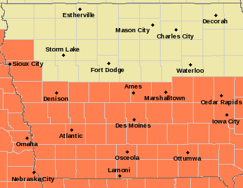
A Heat Advisory put into effect Monday continues for today, effective from Noon until 7-p.m. all counties in the KJAN listening area are included in the Advisory.
* WHAT…Heat index values up around 105 expected.
* WHERE…Central and Southern Iowa, roughly Highway 30 and south.
* IMPACTS…Hot temperatures and high humidity may cause heat illnesses to occur.
PRECAUTIONARY/PREPAREDNESS ACTIONS…
Drink plenty of fluids, stay in an air-conditioned room, stay out of the sun, and check up on relatives and neighbors. Young
children and pets should never be left unattended in vehicles under any circumstances.
Take extra precautions if you work or spend time outside. When possible reschedule strenuous activities to early morning or evening. Know the signs and symptoms of heat exhaustion and heat stroke. Wear lightweight and loose fitting clothing when possible. To reduce risk during outdoor work, the Occupational Safety and Health Administration recommends scheduling frequent rest breaks in shaded or air conditioned environments. Anyone overcome by heat should be moved to a cool and shaded location. Heat stroke is an emergency! Call 9 1 1.
Today: Sunny, with a high near 83. Light and variable wind becoming south southeast 9 to 14 mph in the morning. Winds could gust as high as 18 mph.
Tonight: A 20 percent chance of showers and thunderstorms after 2am. Increasing clouds, with a low around 69. South southeast wind 7 to 11 mph, with gusts as high as 21 mph.
Monday: A 20 percent chance of showers and thunderstorms after 1pm. Mostly sunny, with a high near 91. Heat index values as high as 100. South wind 6 to 11 mph, with gusts as high as 20 mph.
Monday Night: A 20 percent chance of showers and thunderstorms before 1am. Partly cloudy, with a low around 69. South wind around 6 mph.
Tuesday: Sunny, with a high near 92. South wind 6 to 13 mph, with gusts as high as 18 mph.
Wednesday: A 20 percent chance of showers and thunderstorms after 1pm. Sunny, with a high near 86.
Saturday’s High in Atlantic was 77. Our Low this morning, 54 (as of 5-a.m.). Last year on this date, the High in Atlantic was 90, and the Low was 62. The Record High was 100 degrees in 1914, and the Record Low was 41 in 1904.
TODAY: Mostly sunny skies NW @ 10-15 High 81
TONIGHT: Clear with light and variable winds Low 54
SUNDAY: Partly cloudy with some scattered showers and thunderstorms late in the day SE @ 10 High 86
MONDAY: Some scattered showers and thunderstorms early, then becoming partly cloudy. High 90
TUESDAY: Partly cloudy High 92
Rainfall overnight: 0.25″


