
Today: Mostly sunny. High near 70. NW @ 10-20.
Tonight: Mostly clear. Low 38.
Tomorrow: Mo. Sunny. High around 70. N @ 5-10.
Thursday: P/Cldy. High 79.
Friday: P/Cldy. High 75.
Monday’s High in Atlantic was 80. Our Low this morning, 49. We received .08″ rain Monday morning. Last year on this date the High in Atlantic was 76 and the Low was 53. The Record High on this date was 96 in 1937. The Record Low was 29 in 1918 & 1999.
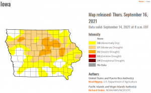
(Radio Iowa) -Autumn arrives this week, but forecasters don’t expect much change in terms of the warmer, drier weather for the next month or so. Brian Fuchs, a climatologist with the National Drought Mitigation Center, says October temperatures look to stay above-normal. “Those above-normal chances of above-normal temperatures are really holding pat,” Fuchs says, “especially from Colorado through Nebraska up into the Midwestern states where that probability is 50 to 60% probability of seeing above-normal temperatures during that time, which is pretty high.”
After months of drought, Fuchs says the predictions show little change in rainfall is likely in the month ahead.”For precipitation, we’re seeing above-normal chances of below-normal precipitation in portions of the Central Plains,” Fuchs says, “but as we go further east, we start seeing equal chances to above-normal chances of above-normal precipitation during the month of October.”
Fuchs says the trends for the 90-day outlook aren’t much different. “There’s above-normal chances of above-normal temperatures and for precipitation, we’re seeing some of the area above-normal chances for above-normal precipitation,” Fuchs says, “but a lot of equal chances and above-normal chances of below-normal precipitation.”
Fall arrives Wednesday.
Today: Sunny & breezy, with a high near 89. South wind 5-15 mph this morning, gusting to near 30 this afternoon.
Tonight: Mostly clear w/just a slight chance of showers and thunderstorms before sunrise on Monday. Low around 67. S/SE @ 15-25.
Monday: Showers and thunderstorms, mainly after 1pm. High near 78. S winds @ 10-20 in the morning becoming NW during the afternoon & gusting to near 30. New rainfall amounts between a tenth and quarter of an inch, except higher amounts possible in thunderstorms.
Monday Night: Showers and thunderstorms likely before 10pm, then a slight chance of showers & partly cloudy. Low around 50. N/NW @ 15-25. New precipitation amounts of less than a tenth of an inch, except higher amounts possible in thunderstorms.
Tuesday: Sunny, with a high near 70. North northwest wind 7 to 15 mph, with gusts as high as 21 mph.
Wednesday: Sunny, with a high near 70.
Saturday’s High in Atlantic was 88. Our Low was 54. Last year on this date, the High was 74 and the Low was 44. The Record High was 95 in 1948. The Record Low was 33, in 1896 and 1938.
TODAY: Some patchy fog this morning, then mostly sunny. SE 10 High 85
TONIGHT: Fair to partly cloudy. S 5-10 Low 64
SUNDAY: Mostly sunny SW 10-20 High around 90
MONDAY: Mostly cloudy with showers and thunderstorms. High 80
TUESDAY: Partly cloudy and cooler. High around 70
Friday’s High was 77 and the Low was 50. Last year on this date, the High was 74 and the Low was 43.
The record High was 99 in 1893 and the record Low was 26 in 1901
Tomorrow: P/Cldy. High 85. SE @ 10-15.
Sunday: P/Cldy. High 89.
Monday: P/Cldy. High 85.
Thursday’s High in Atlantic was 90, and the Low was 61. Last year on this date (9/17), the High in Atlantic was 81 and the Low was 46. The Record High was 97 in 1925, and the Record Low was 31 in 1980.
Today: Mostly sunny. High 89. S @ 15-25.
Tonight: Partly cloudy. Low 68. S @ 10.
Tomorrow: P/Cldy w/isolated showers & thunderstorms. High 80. S @ 10-15.
Saturday: P/Cldy. High 85.
Sunday: P/Cldy. High 89.
Wednesday’s High in Atlantic was 82, and the Low was 47. Last year on this date (9/16), the High in Atlantic was 83 and the Low was 58. The Record High was 95 in 1931, and the Record Low was 28 in 1893.
Today: Sunny to partly sunny. High 81. SE @ 10.
Tonight: Mostly clear. Low 62.
Tomorrow: Mo. Sunny. High 88. S @ 15-20.
Tom. Night: A slight chance of showers, otherwise mostly clear. Low 67.
Friday: Mo. Sunny w/a 40% chance of late day showers. High 82. S @ 5-10.
Friday Night: Mostly cloudy w/a slight chance of showers. Low 63.
Saturday: Mo. Sunny. High 88.
Sunday: Mo. Sunny. High around 90.
Tueday’s High in Atlantic was 79. Our Low this morning, 48. Last year on this date the High in Atlantic was 80 and the Low was 46. The Record High on this date was 99 in 1939. The Record Low was 31 in 1961.
Today: Partly sunny w/a slight chance of late day showers. High 78. SW @ 15-20.
Tonight: Mostly clear. Low 52.
Tomorrow: Partly cloudy to cloudy. High 82. S/SE @ 5-10.
Tom. Night: Mo. Clear. Low 63.
Thursday: Mo. Sunny. High 88. S @ 15-25
Friday: Mostly sunny. High 87.
Saturday: Mo. Sunny. High 86.
Monday’s High in Atlantic was 87. Our Low was 61. Last year on this date the High in Atlantic was 82 and the Low was 44. The Record High on this date was 99 in 1939. The Record Low was 29 in 1892.


