
Today: Partly cloudy. High around 52. NW @ 15-25.
Tonight: Mostly clear. Low 22. Winds NW @ 5-10.
Tomorrow: Mostly sunny. High 43. NW @ 10-15.
Friday: P/Cldy. High 52.
Saturday: P/Cldy. High 58.
Tuesday’s High in Atlantic was 70. Our Low was 37. Last year on this date the High in Atlantic was 52 and the Low was 27. The Record High on this date was 73 in 1941. The Record Low was -2 in 1959.
Today: Mostly sunny. High around 70. SW @ 15-25.
Tonight: P/Cldy. Low 35. Winds NW @ 10-15.
Tomorrow: P/Cldy. High 52. NW @ 10-20.
Thursday: Mo. Sunny. High 42.
Friday: Partly cloudy. High near 50.
Monday’s High in 56. Our Low this morning, 34. Last year on this date the High in Atlantic was 58 and the Low was 18. The Record High on this date was 73 in 2001. The Record Low was 1 in 1955.
Today: Cloudy to partly cloudy. High around 58. S/SE @ 10-20.
Tonight: Fair to P/Cldy. Low 28. Winds S @ 5.
Tomorrw: Mostly sunny. High near 70. SW @ 15-25.
Wednesday: P/Cldy. High 52.
Thursday: Partly cloudy. High 42.
Sunday’s High in Atlantic was 43. Our Low was 28. Last year on this date the High in Atlantic was 47 and the Low was 17. The Record High on this date was 75 in 200. The Record Low was -7 in 1940.
Today: Mostly sunny, with a high near 40. Breezy, with a northwest wind 12 to 17 mph decreasing to 5 to 10 mph in the afternoon. Winds could gust as high as 32 mph.
Tonight: Increasing clouds, with a steady temperature around 34. Light and variable wind becoming south southeast 6 to 11 mph after midnight. Winds could gust as high as 21 mph.
Monday: Mostly sunny, with a high near 60. South wind 6 to 10 mph becoming west in the morning. Winds could gust as high as 21 mph.
Tuesday: Mostly sunny, with a high near 66. Breezy, with a south wind 8 to 16 mph, with gusts as high as 24 mph.
Wednesday: Partly sunny, with a high near 46. Breezy.
Saturday’s high was 48 and the low overnight was 28. This day last year the high was 62 and the low 34. The all-time record high was 72 set in 1897, 1964 & 1990. The record low was -5 set in 1940. Sunrise today is 7:07 a.m. Sunset tonight 5:01 p.m.
Skyscan Forecast Saturday, November 13, 2021 Dan Hicks
Today: Partly cloudy to cloudy. NW shifting to SW @ 10. High 44.
Tonight: Mostly cloudy. Light rain/snow mix. S shifting to N @ 10-15. Low 34.
Sunday: Partly cloudy to cloudy. N @ 15-25. High 40.
Sunday Night: Mostly cloudy. SSE @ 5-10. Low 29.
Monday: Partly cloudy. High 52.
Tuesday: Partly cloudy. High 68.
Yesterday’s high was 33 and the low overnight was 28. This day last year the high was 43 and the low 12. The all-time record high was 83 set in 1999. The record low was -5 set in 1940. Sunrise today is 7:06 a.m. Sunset tonight 5:02 p.m.
(Radio Iowa) – As flurries fly across much of the state today (Friday), the experts still aren’t able to nail down what type of winter may lie ahead for Iowa or the Midwest. National Weather Service meteorologist Brett Albright says the forecast of another La Nina weather pattern will drive the winter weather across the Northern Plains, but how much snow may fall is still anyone’s guess. “In terms of total precip that we’re expecting here in Iowa and Nebraska, we could be above normal or below, there really isn’t a strong way to predict where that’s going to fall,” Albright says. “It does look like to our south, it’s going to be below, and then we’re caught in between a couple of areas here of above-normal precip being most likely this winter.”
The forecast models also show essentially a 50-50 chance of below- versus above-normal temperatures. Still, Albright says there is a narrow possibility of more snow in Iowa later in the winter. “There’s no strong signal for total precipitation, but there is a weak signal for more snowfall, particularly during the second half of the winter,” Albright says. “We’re looking for maybe when will more of our snow fall? We’d be looking more at certainly January into February if not latter January into February for the best, the highest chances of more of that snowfall.”
Despite recent heavy rains, the Climate Prediction Center is forecasting drought conditions to linger across much of the region into next spring.
Today: **WIND ADVISORY until 6-p.m.** Cloudy & windy w/occasional light snow or flurries. Little or no snow accumulation is expected. High nearly steady in the 30’s. Winds NW @ 20-40 w/higher gusts.
Tonight: Cloudy to P/Cldy. Low around 20. Winds diminishing to around 15-20.
Tomorrw: P/Cldy. High 45. SW @ 5-10.
Sunday: Mostly cloudy w/a chance of light snow/mixed precip. in the morning. High near 40.
Monday: Partly cloudy. High 52.
Thursday’s High in Atlantic was 52. Our Low this morning, 33. We received a trace of precipitation this morning in the form of snow flurries. Last year on this date the High in Atlantic was 48 and the Low was 12. The Record High on this date was 73 in 2005. The Record Low was -4 in 1968 & 2019.
Area Counties: Sac-Crawford-Carroll-Audubon-Guthrie-Dallas-Cass-Adair-Madison-Monona-Harrison-Shelby-Pottawattamie-Mills….
325 AM CST Fri Nov 12 2021
…A WIND ADVISORY REMAINS IN EFFECT UNTIL 6 PM CST THIS EVENING…
* WHAT…West to northwest winds 25 to 35 mph with gusts to around 50 mph expected.
* IMPACTS…Gusty winds could blow around unsecured objects.
PRECAUTIONARY/PREPAREDNESS ACTIONS…
Use extra caution when driving, especially if operating a high profile vehicle. Secure outdoor objects.
Audubon-Guthrie-Dallas-Cass-Adair-Madison-Sac-Crawford & Carroll Counties…
WIND ADVISORY IN EFFECT FROM 9 PM THIS EVENING TO 6 PM CST FRIDAY…
* WHAT…West to northwest winds 25 to 35 mph with gusts up to 50 mph expected.
* IMPACTS…Gusty winds could blow around unsecured objects.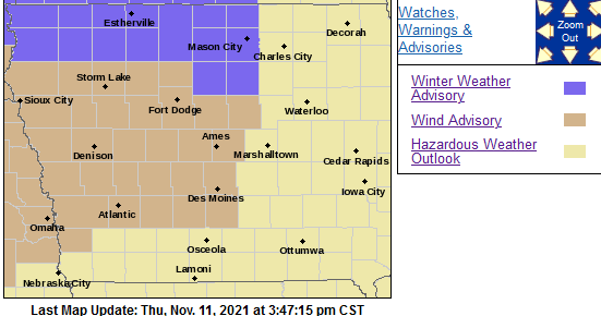
PRECAUTIONARY/PREPAREDNESS ACTIONS…
Use extra caution when driving, especially if operating a high profile vehicle. Secure outdoor objects.
(Radio Iowa) – We still have six more weeks of fall but Ole’ Man Winter is giving us a preview of what’s to come. A Winter Weather Advisory is posted for 15 counties across northwest and north-central Iowa late tonight (Thursday) through Friday afternoon. National Weather Service meteorologist Roger Vachalek says driving could soon become more of a challenge. “We’re going to be looking at stronger winds and also some snow falling over northern Iowa,” Vachalek says. “The combination of those two things will cause some poor travel conditions, especially late tonight, overnight, through tomorrow morning and the commute.”
It’s been a while since most of us have gotten behind the wheel in these conditions, so Vachalek reminds motorists to take it slow and leave for destinations early. “Although we’re not expecting a lot of snow, maybe one to two inches closer to the Iowa-Minnesota border, there will be the possibility of some slick or icy roads and strong winds gusting to 30 or 40 miles per hour,” Vachalek says, “as well as during the rest of the day, we may have snow showers which reduce visibility from time to time.” Most of Iowa is expecting at least a dusting of snow and there’s a chance for -more- snow late this weekend.
“We have another system coming in on Sunday which will probably bring some snow to far northeastern Iowa. We’re keeping an eye on that one,” Vachalek says. “Thankfully though, by next week, Tuesday, we may actually be back in the lower 60s. There’s going to be a sharp turnaround back to warmer weather, at least for a day next week, before we start to cool down again.” How does he describe the upcoming weather pattern? In a word, “wild.”


