
Today: Mostly sunny. High 56. S @ 10.
Tonight: Fair to partly cloudy. Low 30. SE @ 5.
Tomorrow: P/Cldy. High 58. S @ 10-15.
Wednesday: P/Cldy, warm & windy w/a chance of showers & thunderstorms late. High 68. **High Wind Watch in effect**
Thursday: P/Cldy. High 38.
Sunday’s High in Atlantic was 54. Our Low this morning, 30. Last year on this date, the High was 27 and the Low was 6. The Record High was 65 in 1921. The Record Low was -20 in 1961.
Today: Sunny & breezy. High around 49. S/SW winds 10-20 mph w/gusts to near 30.
Tonight: Mostly clear, with a low around 27. South wind 10-20 mph.
Monday: Mostly sunny, with a high near 51.SE winds at 5 to 10 mph in the morning.
Tuesday: Partly sunny, with a high near 56. South wind 5 to 15 mph.
Wednesday: Partly sunny & windy, w/a 20% chance of showers and thunderstorms after noon. High near 71.
Saturday’s High in Atlantic was 42. Our Low this morning, 27. Last year on this date, the High in Atlantic was 32 and the Low was 16. The Record High was 62 in 1921 & 1968. The Record Low was -20 in 1932.
Skyscan Forecast Saturday, December 11, 2021 Dan Hicks
Today: Becoming partly cloudy. NW @ 15-30, shifting to the W @ 10-15 this afternoon. High 40.
Tonight: Fair to partly cloudy. SW @ 5-10. Low 20.
Sunday: Fog early then mostly sunny. SW @ 10-15. High 54.
Monday: Partly cloudy. High 56.
Tuesday: Partly cloudy. High 60.
We picked up a light glaze of ice and .2″ of snow overnight at the KJAN studios. Yesterday’s high was 38 and the low was 28. This day last year the high was 38 and the low 28. The all-time record high for today was 64 set in 1965. Record low was -14 in 1917. Sunrise this morning at 7:36 a.m. and sunset is at 4:50 p.m.
Today: Mostly cloudy w/light rain this afternoon. High around 40. Winds E @ 10-20 mph.
Tonight: Cloudy w/light rain changing to light snow. Low 29. N @ 15-30.
Tomorrow: Light snow ending in the morning; Becoming P/Cldy. High near 40. NW @ 15-30 diminishing in the afternoon.
Sunday: P/Cldy. High 54.
Monday: P/Cldy. High 56.
Thursday’s High in Atlantic was 56. Our Low this morning, 34. Last year on this date the High in Atlantic was 57 and the Low was 23. The Record High on this date was 58 in 1891. The Record Low was -14 in 1917.
Today: Partly cloudy to cloudy w/sprinkles possible this morning. High 52. Winds S-NW @ 10-15 mph.
Tonight: P/Cldy. Low 30.
Tomorrow: Mostly Cloudy w/light rain. High 38. E @ 10-15.
Saturday: Light snow possible early; P/Cldy. High 38.
Sunday: P/Cldy. High near 50.
Wednesday’s High in Atlantic was 42. Our Low was 13. Last year on this date the High in Atlantic was 62 and the Low was 22. The Record High on this date was 62 in 1946 & 2020. The Record Low was -17 in 1917 & 2005.
(Radio Iowa) – Forecasters say the first significant snowfall of the season is headed toward Iowa and 22 counties across the state’s northern third are under a Winter Storm Watch. Meteorologist Roger Vachalek, at the National Weather Service, says moderate-to-heavy snow is possible from Friday afternoon into Saturday morning. “There’s about a 40- to 50-percent chance in the northwestern counties of seeing more than six inches of snow but four to five inches is a pretty sure bet,” Vachalek says. “The farther south you get toward the Des Moines metro, there’s about a 50-percent chance of seeing an inch of snow.”
Snow has already fallen a couple of times in various parts of the state in recent weeks, but this storm promises to be widespread and could potentially paint all but the Keokuk area in white. “Impacts from the storm are going to be the snowfall, of course, but we also have some wind coming in on the back side of it and visibilities will probably be dropping down as well later on Friday afternoon and evening,” Vachalek says. “You’re really going to want to watch this carefully. We haven’t driven for quite a while in this type of weather and people need to be very, very cautious.”
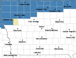
Winter Storm Watch for counties in blue Friday afternoon & Friday night. (NWS)
Folks in parts of southern and central Iowa enjoyed unseasonably warm temperatures last week, with highs in the 60s and near 70. This week is shaping up to be quite chilly, as we’ve had to break out the winter coats, hats and gloves, but the weather rollercoaster will go back up next week. “The snow that falls on Friday, in many cases, may all be melted by next Wednesday or Thursday, as high temperatures rebound into the 50s even as far as northern Iowa,” Vachalek says. “This is very unusual. We call it a high amplitude pattern where we get some big changes or big swings coming into and out of the state.”
With next week’s predicted warm-up, Vachalek says it’s difficult to predict whether any of Iowa will see a White Christmas. We’ll have a better view of the probabilities in another week.
Today: Partly cloudy. High 40. Winds SE @ 10 mph.
Tonight: P/Cldy to Cloudy. Low 30. SE @ 5-10.
Tomorrow: P/Cldy to Cldy. High 50. S-NW @ 10-15.
Friday: Cldy w/light rain. High 38.
Saturday: Cloudy to P/Cldy w/light snow in the morning. High 36.
Tuesday’s High in Atlantic was 41. Our Low was 19. Last year on this date the High in Atlantic was 55 and the Low was 17. The Record High on this date was 67 in 1946. The Record Low was -18 in 1917 & 1976.
Today: Partly cloudy to cloudy w/a chance of flurries this morning. High 37. Winds SE @ 10-15 mph.
Tonight: P/Cloudy. Low around 15. N @ 5-10.
Tomorrow: P/Cldy. High 40. SE @ 5-10.
Thursday: P/Cldy to Cldy. High 50.
Friday: Mostly cloudy w/a chance of light rain. High near 40.
Monday’s High in Atlantic was 26. Our Low was 8. Last year on this date the High in Atlantic was 51 and the Low was 16. The Record High on this date was 64 in 1894. The Record Low was -15 in 2005.
Today: Partly cloudy. High around 28. NW @ 20-40 mph diminishing late.
Tonight: P/Cloudy to cloudy w/a chance of flurries late. Low around 15. SE @ 10-15.
Tomorrow: Mo. Cldy w/flurries in the morning. High around 38. S/SE @ 10-20.
Wednesday: P/Cldy. High 40.
Thursday: Mostly cloudy, with a high near 50.
Sunday’s High in Atlantic was 52. Our Low this morning, 23. Last year on this date the High in Atlantic was 38 and the Low was 22. The Record High on this date was 69 in 1938. The Record Low was -12 in 2005.
Today: Cloudy, then gradually becoming mostly sunny, with a high near 52. Windy, with a south wind 11 to 16 mph becoming northwest 18 to 23 mph in the afternoon. Winds could gust as high as 34 mph.
Tonight: Cloudy during the early evening, then gradual clearing, with a low around 21. Windy, with a northwest wind 20 to 26 mph, with gusts as high as 40 mph.
Monday: Sunny, with a high near 27. Wind chill values as low as 5. Blustery, with a northwest wind 8 to 18 mph, with gusts as high as 28 mph.
Monday Night: A 20 percent chance of snow after midnight. Increasing clouds, with a low around 16. Calm wind becoming southeast 5 to 7 mph after midnight.
Tuesday: Mostly cloudy, with a high near 34. South wind 7 to 14 mph, with gusts as high as 22 mph.
Wednesday: Mostly sunny, with a high near 37.
Saturday High in Atlantic was 47. Our Low was 28. Last year on this date the High in Atlantic was 48 and the Low was 16. The Record High on this date was 66 in 2001. The Record Low was -14 in 2005.


