
(Radio Iowa) – The 14-hundred residents of the northwest Iowa town of Kingsley lost power as Wednesday’s storm damaged power lines, trees and buildings. Duane Walhof is Plymouth County’s Emergency Management director. “Parts of roofs torn off and those type things, mainly on the south side of Kingsley,” Walhof says. “…Titan Machinery had the roof torn off and tossed across the road.”
Walhof says there were reports the roofs of hog barns in rural areas around Kingsley were damaged as well. Walhof says since the storm hit at about 5 p.m., it was difficult to assess damage in the dark. “The National Weather Service will be out to try to identify whether it was straight line winds or a tornado,” Walhof says. “We’ll see what the day brings in how quickly we can get Kingsley back up and restored and back on it again.”
The Plymouth County Sheriff restricted movement within the Kingsley City Limits overnight to residents of the community, to limit the number of sightseers driving through the damage. Kingsley-Pierson School was cancelled for today (Thursday).
Today: Partly cloudy & windy. High 41. NW @ 15-30 mph.
Tonight: P/Cldy. Low 17. Winds light & variable.
Tomorrow: P/Cldy to cloudy. High 41. W @ 5-10.
Saturday: P/Cldy to cldy. High 32.
Sunday: P/Cldy. High 35.
Wednesday’s High in Atlantic of 72 broke the record of 64 set in 2002. Our Low this morning, was 25. We received .16″ of rain yesterday. Last year on this date the High in Atlantic was 23 and the Low was 11. The Record High on this date was 54 in 1962. The Record Low was -22 in 1951.
Here is the latest storm report compiled by the National Weather Service and KJAN, for the severe storms/wind event on Wed., Dec. 15 2021
Time of event/type of event/location/County/source of information
7:45-p.m. Cass County Communications reports Olive Street is closed north of Atlantic from Great River Road to Chicago Road, due to downed power lines. Barricades are in-place.
7:35-p.m. 66 mph thunderstorm wind gust 3 miles south of Creston.
7:15-p.m 59 mph gust 1 mile S/SE of Clarinda
5:56-p.m. Thunderstorm wind damage 1 mile N/NE of Creston: Tree fell on a house (Time estimated)
5:55-p.m. 70 mph thunderstorm wind gust 3 miles south of Creston. (MesoNet)
5:48-p.m. Accident w/minor injuries, I-80 mm59 wb
5:35-p.m. Thunderstorm wind damage: Outbuilding destroyed at 240th & Timber Ave; Carroll County.

Power lines down north of Atlantic Wed. night (Photo courtesy Ashley Skow)
5:34-p.m. Power lines down north of Atlantic on Troublesome Creek between Olive Street & Great River RD. (KJAN listener report)
534-p.m. Semi rollover on I-29 miles N/NW of Pacific Junction at mm 35.
5:34-p.m. Thunderstorm wind damage in Neola: Out buildings blown over, houses damaged, power lines down, gas leak.
5:32-p.m. Tstrm wind damage: Outbuilding destroyed near Yale (Guthrie County)
5:31-p.m. 70 mph wind gust in Ralston (Carroll County)
5:30-p.m. rollover accident on I-80 wb between 60-61mm; Atlantic Fire & Rescue/Cass EMS dispatched
517-p.m. 1/2″ diameter hail, tstrm winds up to 65 mph 8 miles W. of Guthrie Center; EMA
515-p.m. estimated 80 mph gust 2 miles S. of Adair; Zero visibility south of Adair.
5:15-p.m. semi rollover near 71968 630th St. in Cass County, near Muller Livestock.
5:15-p.m. 61 mph tstrm wind gust 1 mile S/SE of Clarinda.
5:02-p.m. Tornado on the ground 1 mile NW of Atlantic (storm chase & video confirmed)
5:02-p.m. Weather spotters confirm a tornado crossing I-80 north of Atlantic
5:02-p.m. Semi rolled over 3 miles W. of McClelland on I-80 mm
5:01-p.m. Tornado confirmed 3 miles S/SW of Brayton; Storm spotter reported flipped semi’s and power flashes.
5:00-p.m. Trees blocking one lane of 570th in the area of Whitepole Road.
4:55-p.m. Rollover accident 590th and Tucson in Cass County.
4:55-p.m. 72 mph tstrm gust at the Harlan Airport.
4:53-p.m. Semi on I-80 WB near Shelby (Twitter photo)
4:53-p.m. Tstrm wind damage 2 miles S. of Woodbine: Trees uprooted or snapped; Roof blown off
4:38-p.m. Tstrm wind damage 1 mile NE of Underwood: Large garage doors on a city building were blown-in.
4:38-p.m. Tstrm wind gust of 80 mph 2 miles SE of Underwood.
4:36-p.m. Tstrm wind gust of 79 mph 5 miles E/NE of Council Bluffs.
4:29-p.m. Tstrm wind damage 4 miles W. of Underwood: roof blown off a home on L-34.
4:27-p.m. Tstrm wind damage 1 mile NW of Treynor: Powerlines down. P
425-p.m. Tstrm wind damage 3 miles N/NW of McClelland; Major home damage in Weston.
4:24-p.m. Tstrm wind damage 5 miles W of McClelland: Fire Chief reports power lines and power poles down for about 1.4 of a mile, from Homestead to L-34 along Railroad Hwy.
4:22-p.m. Tstrm wind damage 2 miles N. of Malvern: power lines down across Hwy 34.
4:22-p.m. 81 mph gust at Offutt AFB in NE
4:22-p.m. 83 mph gust near Missouri Valley
4:22-p.m. Tstrms wind gust of 83 mph 8 miles W/SW of Sidney at I-29/Hwy 2 (MesoNet station)
4:21-p.m. Nine loaded coal cars rolled off the tracks 1 mile E/NE of Council Bluffs.
(Atlantic, Iowa) – What some meteorologists are calling an “Unprecedented” weather event is staged to sweep across Iowa this afternoon and evening, bringing destructive winds and tornadoes. Cass County Emergency Management Coordinator Mike Kennon tells KJAN News this storm system could present as strong or stronger straight line winds than the August Derecho that caused millions of dollars in damage across the state.
The storm system is expected to push through from west to east at up to 80 miles per hour.
Kennon advises you to keep abreast of the latest developments in this fast mover.
Once the storm front passes through, you need to be prepared to encounter downed power line and tree limbs, not to mention debris from area properties. In your home or business, remember to go the interior of your structure when strong winds and tornadoes are in the area.
(Johnston, Iowa) – The National Weather Service, today (Wednesday), reports widespread very strong winds are anticipated this afternoon and this evening, but severe thunderstorms are possible as well. A line of severe thunderstorms is expected to move rapidly west to east across central Iowa between 4pm and 8pm at speeds of 60 to 70 mph. The primary severe weather threats will be damaging winds and a few tornadoes. With non-thunderstorm winds already gusting from 60 to 70 mph, winds in thunderstorms could reach 80 mph or more.
Conditions could change very rapidly today with little reaction time as storms approach. Monitor weather conditions closely with safe shelter available and nearby.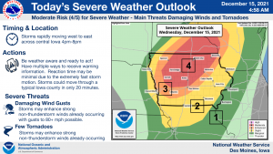
Today: Partly cloudy to cloudy & very windy. A chance of showers & thunderstorms w/severe storms possible later today. **HIGH WIND WARNING from Noon until midnight**High 70. S @ 20-40 w/gusts to 50+ mph.
Tonight: Showers & thunderstorms ending late. Low 30. W/SW @ 20-40 w/gusts 50+ before diminishing overnight.
Tomorrow: P/Cldy & cooler. High 41. W/NW @ 10-20.
Friday: P/Cldy. High 44.
Saturday: P/Cldy to cldy. High 32.
Tuesday’s High in Atlantic was 59 (24-hour high ending today at 7-a.m.). Our 24-hours Low was 27. Last year on this date the High in Atlantic was 23 and the Low was 7. The Record High on this date was 64 in 2002. The Record Low was -19 in 1901.
(Harlan) – Shelby County Emergency Management Coordinator Alex Longo reports Shelby County will be in a burn ban, effective immediately, and lasting until 8-a.m. Thursday, Dec. 16th. A Burn Ban is issued by local or state officials, at the request of local fire chiefs, during periods of extremely dry conditions or under other conditions, when open burning may constitute a danger to life or property. 
There is a High Wind Warning in effect for Wednesday across most of Iowa. Any fires that do start, either accidentally or otherwise, can be explosive and spread quickly. Violating the Burn Ban is a simple misdemeanor, punishable by a fine. For more information, call 712-755-2124.
Today: Partly cloudy. High 58. S @ 10-15.
Tonight: P/Cldy. Low 46. S @ 5-10.
Tomorrow: P/Cldy w/a chance of late showers & tstrms. HIGH WIND WARNING from Noon until Midnight. High 68. S @ 15-30 w/gusts to near 70.
Thursday: P/Cldy. High 39.
Friday: P/Cldy. High 44.
Monday’s High in Atlantic was 55. Our Low was 23. Last year on this date, the High was 27 and the Low was 6. The Record High was 59 in 1975. The Record Low was -19 in 1901 & 1972.
(Radio Iowa) – A D-N-R expert says the state’s drought situation has improved dramatically as we enter the winter. Tim Hall says the drought isn’t completely gone. “Right now about half the state is shown in some sort of drought condition — but most of that is D-zero — which is abnormally dry,” Hall says. “Now there’s a little stretch of D-1 moderate drought kind of winding its way from north-central Iowa down toward Waterloo in little patches.” Hall says the wet October was the big turning point — as a dry November didn’t help. “Had we seen normal rainfall in November — we might have gotten some improvement. Right now, the conditions are holding pretty steady in the state at about 13-percent of the state is now shown as D-1 moderate drought. And the total amount of the state shown in some form of drought is just over 50 percent,” according to Hall.
Hall says the warmer temperatures have left the ground warmer and the door open for any moisture that falls to still be helpful. “It’s not frozen yet. It’ll take a pretty decent stretch of cold weather to get that soil frozen — especially at the top,” he says. “Once that soil at the ground surface freezes — that pretty much shuts down the infiltration of moisture. So, hopefully, we’ll get a few more weeks where we can get some water into the ground.” He says any rain or snow we get now is a bonus. “It’s really important to keep an eye on what’s going on here probably for the next couple of weeks. Any moisture we get will help us out — because it’ll get locked into the soil profile,” Hall says.
Hall says the water that gets into the ground now will be key when it comes time to plant once again in the spring.


