Today: Mostly sunny, with a high near 39. Breezy, with a light and variable wind becoming north northwest 11 to 16 mph in the morning. Winds could gust as high as 26 mph.
Tonight: Mostly clear, with a low around 18. North northwest wind 5 to 9 mph becoming calm in the evening. Winds could gust as high as 18 mph.
Monday: Mostly sunny, with a high near 47. South southwest wind 5 to 7 mph becoming west in the afternoon.
Monday Night: Mostly clear, with a low around 24. South southwest wind 3 to 6 mph.
Tuesday: Mostly sunny, with a high near 52. South southwest wind 7 to 15 mph becoming northwest in the afternoon. Winds could gust as high as 22 mph.
Wednesday: Mostly sunny, with a high near 45. Breezy.
Saturday’s High in Atlantic was 52 and the low overnight was 11. This day last year we had a high of 11 and a low of -17. The all-time record high for today’s date was 54 in 1966 and the record low was -27 in 1982. Sunrise today is 7:27 a.m. Sunset tonight at 5:42 p.m.
Skyscan Forecast Saturday, February 5, 2022 Dan Hicks
Today: Partly cloudy. SW 10-20. High 42.
Tonight: Partly cloudy. S @ 5-10. Low 27.
Sunday: Partly cloudy. N @ 10-15. High 36.
Sunday Night: Partly cloudy. NNW @ 5-10. Low 15.
Monday: Partly cloudy. High 40.
Tuesday: Partly cloudy. Mild. High 50.
Yesterday’s high was 27 and the low overnight was 3. This day last year we had a high of 21 and a low of -3. The all-time record high for today’s date was 66 in 1948 and the record low was -26 in 1936. Sunrise today is 7:28 a.m. Sunset tonight at 5:41 p.m.
Today: Partly cloudy. High 27. SW-NW @ 10-20 mph. Wind Chill as low as -10
Tonight: Fair to P/Cldy. Low 5. Winds diminishing to 5-10 mph. Wind Chill as low as -10.
Tomorrow: P/Cldy. High near 40. SW @ 10-20.
Sunday: P/Cldy. High near 30.
Monday: P/Cldy. High 39.
Thursday’s High in Atlantic was 15. Our Low morning was -4. Last year on this date the High in Atlantic was 62 and the Low was 11. The Record High was 62 in 1938. The Record Low was -30 in 1905.
Today: Partly cloudy. High 14. N winds @ 10-20 mph. Wind Chill as low as -20. *Wind Chill Advisory until 10-a.m.**
Tonight: Fair to P/Cldy. Low around -4. Winds light & variable. Wind Chill as low as -10.
Tomorrow: P/Cldy. High 28. S winds becoming W/NW @ 10-15.
Saturday: P/Cldy. High 39.
Sunday: P/Cldy. High 29.
Wednesday’s High in Atlantic was 16. Our this morning was -4. Last year on this date the High in Atlantic was 43 and the Low was 23. The Record High was 60 in 1934. The Record Low was -29 in 1996.
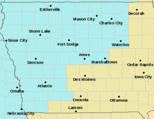
(NWS/Des Moines, Iowa) – .Another Round of Bitter Cold Wind Chills is in store for us this morning. The combination of very cold temperatures and winds will produce bitter wind chills into the morning over portions of the listening area. Additional wind chill headlines may be needed tonight into Friday morning with forecast wind chill values around 20 to 25 degrees below zero. The cold wind chills could cause frostbite on exposed skin in as little as 30 minutes or less. Use caution while traveling outside. Wear appropriate clothing, a hat, and gloves. 
A WIND CHILL ADVISORY is currently in effect until 10-a.m. today (2/3/22) for the following area counties in Iowa: Sac-Crawford-Carroll-Audubon-Guthrie-Cass-Adair-Adams and Union, and until 11-a.m. for Monona-Harrison-Shelby-Pottawattamie-Mills-Montgomery-Fremont and Page Counties.
(Des Moines, Iowa) – NOAA’s National Weather Service has once again recognized Adair & Guthrie Counties as a StormReady counties. The StormReady program helps community leaders and residents prepare for hazardous weather and flooding. StormReady sites have made a strong commitment to implement plans and resources in an effort to save lives and protect property when severe weather strikes. Chad Hahn, National Weather Service Warning Coordination Meteorologist says “Adair & Guthrie County Emergency Management has taken proactive steps to plan and prepare for weather impacts in an effort to help build a Weather-Ready Nation.”
The nationwide community preparedness program uses a grassroots approach to help communities and organizations develop plans to handle local severe weather and flooding threats. The voluntary program started in 1999. There are now more than 2,350 StormReady communities across the country working to build a Weather-Ready Nation. 
To be recognized as StormReady, an organization must:
The StormReady recognition will be in effect for four years 2022-2026 then Adair & Guthrie County Emergency Management will go through a renewal process. Adair & Guthrie County Emergency Management is also an Ambassador for the Weather-Ready Nation Program. As an Ambassador, the agency along with the National Weather Service is working with its partners to build a Weather-Ready Nation to support community resilience in the face of increasing vulnerability to extreme weather.
Today: Mostly cloudy w/a chance of flurries. High 16. N winds @ 15-25 mph.
Tonight: P/Cldy. Low around -4. NW @ 10-20. **Wind Chill Advisory in effect from 12-a.m. Thu. thru mid-morning**
Tomorrow: P/Cldy. High 14. N @ 10-20.
Friday: P/Cldy. High 28.
Saturday: P/Cldy with a high around 25.
Tuesday’s High in Atlantic was 35. Our (24-hour) Low ending this morning at 7-a.m., was 7. Last year on this date the High in Atlantic was 31 and the Low was 19. The Record High was 66 in 1992. The Record Low was -36 in 1905.
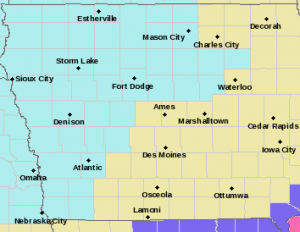
Area Counties: Sac-Crawford-Carroll-Audubon-Guthrie-Cass: WIND CHILL ADVISORY in effect beginning at 12-a.m. Thursday and ending at 9-a.m., and until 11-a.m. Thursday for Monona-Harrison-Shelby-Pottawattamie-Mills-Montgomery-Fremont-Page Counties.
* WHAT…Very cold wind chills expected. Wind chills as low as 25 below zero.
* IMPACTS…The cold wind chills could cause frostbite on exposed skin in as little as 30 minutes.
PRECAUTIONARY/PREPAREDNESS ACTIONS…
Use caution while traveling outside. Wear appropriate clothing, a hat, and gloves.
(Radio Iowa) – January saw colder than normal temperatures statewide and parts of the state had above average snowfall. State climatologist Justin Glisan (like listen) compiles the temperature data. “We were five degrees below average across the state and anywhere from two to eight degrees below average if you look at eastern Iowa where we had a little more snowpack,” Glisan says.
January was drier than normal if you average it out statewide. “We were about a quarter-inch below average, but January is the driest month of the year and it doesn’t take a lot to be above or below average,” according to Glisan. “And then if we look at the actual snowpack that we’ve had — about eight and a half inches across the state. And that was basically above average across much of southeast and central Iowa. And that’s about an inch above average.”
With groundhog day coming up — many are wondering what is ahead for the rest of winter. Glisan says the early indications show February not being as cold as the month was one year ago. “Now we see in the short term getting out into the middle of February — near normal to slightly elevated shots of warmer conditions,” he says. Glisan says that could mean not as much precipitation. “This time of year when we do see warmer conditions we generally see a drier signal or near-normal conditions — but we are seeing an elevated signal for drier conditions for the first half of the month,” Glisan says. “If we look at the monthly outlooks in general that were issued on January 31st — we are not seeing any real clear guidance for the full month.”
Glisan joked that without a clear signal we’ll have to wait to see what Puxatawny Phil says will happen.
(Atlantic, Iowa) – Weather data for the month of January, 2022 in Atlantic, shows the temperatures were about normal, with below normal precipitation. The average High last month was 31 (normally it’s 29). The average Low was 5 degrees, which is 4 degrees below the norm. The warmest day was January 12th (55 degrees), and the coldest morning was on the 2nd, when we bottomed out at -11.
Precipitation for the month, which includes melted snowfall, amounted to just .57″ (which is nearly .3″ below the norm). Snowfall amounted to 4.4″ altogether. January 14th brought the most snowfall, at 2.8 inches.
During the month of February in Atlantic, we typically see a little under one-inch of precipitation [.96″] (Including melted snowfall). The Average High is 35, and the average Low is 15 Degrees.
We’ll let you know how the data compared to those stats, when we compile the data next month.