
Sac-Crawford-Carroll Counties…..WIND ADVISORY IN EFFECT UNTIL 6 PM.
* WHAT…Northwest winds 25 to 35 mph with gusts up to 55 mph.
* IMPACTS…Gusty winds could blow around unsecured objects. Tree limbs could be blown down and a few power outages may result.
* ADDITIONAL DETAILS…Snow showers may accompany the strong and blustery winds producing localized areas of reduced visibility.
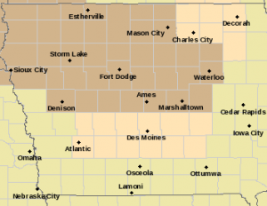
Wind Advisory until 6-p.m. for counties in brown
PRECAUTIONARY/PREPAREDNESS ACTIONS…
Use extra caution when driving, especially if operating a high profile vehicle. Secure outdoor objects.
Today: Partly cloudy to cloudy w/sprinkles/light rain this morning. High 45 early, w/temps dropping into the 30’s this afternoon. Winds NW @ 15-30 mph.
Tonight: Becoming p/cldy w/diminishing winds. Low near 0. N/NW @ 10-15.
Tomorrow: Mostly sunny & cold. High 23. NW-SW @ 10.
Sunday: P/Cldy to Cldy. High near 30.
Monday: P/Cldy. High 37.
Thursday’s High in Atlantic was 52. Our Low was 14. 24-hour Rainfall (7-a.m.) was .1″. Last year on this date the High in Atlantic was 5 and the Low was -10. The Record High on this date was 64 in 1951 & 1999. The Record Low was -26 in 1899.
Today: Partly cloudy. High 45. Winds NW-SW @ 10-15 mph.
Tonight: Mostly cloudy w/a channce of light rain. Low 35. NW @ 10-15.
Tomorrow: P/Cldy to cldy. High 41. NW @ 15-25.
Saturday: Mo. Sunny & colder. High near 24.
Sunday: P/Cldy to Cldy. High 32.
Wednesday’s High in Atlantic was 53. Our Low this morning was 15. Last year on this date the High in Atlantic was 13 and the Low was -10. The Record High on this date was 72 in 1999. The Record Low was -24 in 1905.
Today: Partly cloudy. High 47. Winds NW @ 10-20 mph.
Tonight: Fair to P/Cldy. Low 20. NW @ 5.
Tomorrow: P/Cldy. High 45. SW @ 5-10.
Friday: Mo. Cldy w/a chance of light rain or flurries. High near 40.
Saturday: Mostly cloudy. High 27.
Tuesday’s High of 62 in Atlantic tied the record for Feb. 8th set back in 1954! Our low was 34. This day last year we had a high of 8 and a low of -22. The all-time record high for today’s date was 59 in 1954, 2000 & 2009. The record low was -36 in 1975. Sunrise today is 7:23 a.m. Sunset tonight at 5:46 p.m.
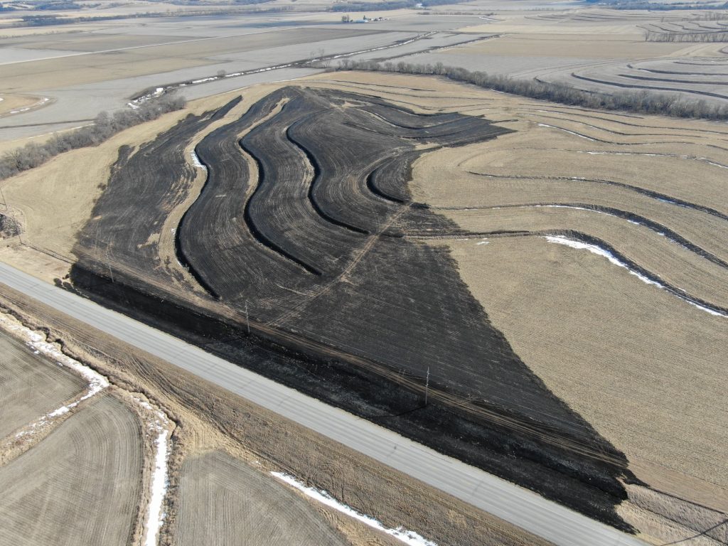
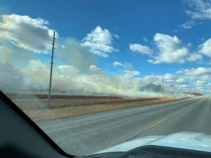
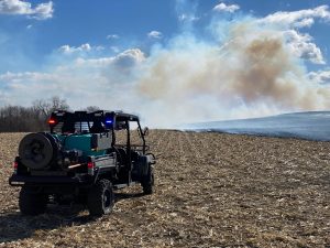
(Council Bluffs, Iowa) – An open burning ban will be in place for Pottawattamie County starting today (February 8, 2022) at 2:00 p.m. The ban prohibits all open and controlled burning in Pottawattamie County, including all incorporated city limits within the county. The current weather forecast and environmental conditions indicate a very high fire danger for today with a warm/dry pattern continuing over the next couple of weeks. Under the current dry conditions, dead and drying vegetation is the perfect fuel to spread fires rapidly.
Emergency Management Director Doug Reed says “Pottawattamie County has seen the devastating effects of fire in extreme conditions and we want to do everything we can to help mitigate incidents like that from occurring.” During these dry conditions, citizens are reminded to not throw out cigarettes from moving vehicles and to discontinue burning yard waste, piled tree debris, grass/agricultural ground and set-asides or other items during the ban. 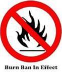
Small recreational camp fires are permitted only if they are conducted in a fire place of brick, metal or heavy one-inch wire mesh. Any camp fire not in an outdoor fire place is prohibited.
Violation of a burn ban can subject a person to citation or arrest for reckless use of fire or disobeying a burn ban.
For updated information on burn bans and the law you can find further information on the Pott. County EMA Facebook, Twitter, and web pages. The ban will remain in place until environmental conditions improve
(Greenfield, Iowa) – The Adair & Guthrie County Emergency Management Agency will host a Storm Spotter Class at the Menlo Community Center, March 16th, beginning at 7-p.m. Emergency Management Coordinator Robert Kempf says the class is free and open to the public. The following week, March 21-25, is designated as Severe Weather Awareness Week in Iowa.
The daily highlights of Severe Weather Awareness Week are Severe Thunderstorms on Monday, receiving Warning Information on Tuesday, Tornadoes on Wednesday, Family Preparedness on Thursday and Flash Floods on Friday. Schools, businesses, government facilities, and individuals are strongly encouraged to conduct Tornado Drills on Wednesday. Local communities should also be test their sirens on Wednesday. 
During Severe Weather Awareness Week, HSEMD will post information on individual and family preparedness at www.BeReady.iowa.gov, including podcasts, public service announcements and videos. The NWS the National Weather Service (NWS) will promote severe weather safety on their websites and by issuing informative public information statements.
Additional information about severe weather and family safety can be found at: www.BeReady.iowa.gov.
(Radio Iowa) – Weather experts are still studying the powerful derecho that hit Iowa two months ago and they’ve determined the wind storm spawned a record number of tornadoes in several categories. Rod Donavon, a meteorologist at the National Weather Service in Johnston, says that single storm spun off more than five-dozen twisters, a startling number, especially in one day. “We have verified 63 tornadoes across Iowa for the December 15th event, which is actually a daily record of tornadoes for Iowa,” Donavon says. “We’ve been doing a lot of work, checking out anywhere anybody’s had damage. We even used high-resolution satellite data to help track down all of these tornadoes.”
One person in eastern Iowa was killed in the December 15th storms, which caused extensive damage in multiple Iowa counties. Donavon says there’s an unusual coincidence with the two previous dates for single-day tornado records in Iowa. “Number-two was actually August 31st of 2014 when we had 35 (tornadoes) and I’ll add into that number-three was April 11th of 2001 when we had 28,” Donavon says. “When you combine the previous top two, that actually equals 63, which is the number we had on December 15th.”
Not only did December 15th set a single day record for tornadoes in Iowa, it set a record for the most tornadoes in a month.”Our previous multi record was 57 from back in May of 2004,” he says. “So it even eclipsed the monthly record.” The December 15th storm set yet another record for the highest number of E-F-2 tornadoes in a single day — at 21. The storm was the second derecho to hit Iowa in recent years. The first tore across the state on August 10th of 2020.
Today: Partly cloudy. High 55. Winds SW-NW @ 10-20 mph.
Tonight: P/Cldy. Low 27. NW @ 5-10.
Tomorrow: P/Cldy. High 43. NW @ 10-20.
Thursday: P/Cldy. High 38.
Friday: Mostly cloudy. High 45.
Monday’s High in Atlantic was 57 and the low was 20. This day last year we had a high of 5 and a low of -22. The all-time record high for today’s date was 62 in 1954 and the record low was -34 in 1971. Sunrise today is 7:25 a.m. Sunset tonight at 5:45 p.m.
Today: Partly cloudy. High 49. Winds SW @ 10-15 mph.
Tonight: P/Cldy. Low 27. SW @ 5.
Tomorrow: P/Cldy. High 55. SW-NW @ 10-20.
Wednesday: P/Cldy. High 43.
Thursday: P/Cldy. High 36.
Sunday’s High in Atlantic was 47 and the low was 15. This day last year we had a high of 3 and a low of -10. The all-time record high for today’s date was 64 in 1987 and the record low was -30 in 1905. Sunrise today is 7:26 a.m. Sunset tonight at 5:43 p.m.


