
(Radio Iowa; UPDATED) – While we’re in the season of state fair corndogs and cotton candy, soon enough, the wicked winds of winter will blow into Iowa, and the new edition of the Farmers’ Almanac isn’t boding well for the seasons to come. Almanac editor Sandi Duncan says their forecast for what lies ahead is under the headline “Wet Winter Whirlwind,” and it predicts Iowa and the rest of the Great Plains states will be facing lower-than-normal temperatures.
“We do see a lot of cold, not freezing cold, it’s going to be overall cold,” Duncan says. “We do see a stormy start to winter in December. January doesn’t look too bad, but then the snow and the wetness and the whirlwind really comes in February in your neck of the woods, with some major storms coming at the beginning as well as the end of the month of February.” Since 1818, the almanac has been using a proprietary formula to forecast the weather, based on historical and celestial factors. In addition to the cold, Duncan says they’re calling for an Iowa winter with average snowfall.
“The whirlwind comes from the idea that looking at both December and February, we do see some back-to-back storms with both snow, rain, sleet, you know, the fun stuff,” Duncan says, “but definitely some snow in February, but nothing too major. Overall, it doesn’t look too bad as far as precipitation goes, but you just expect some snowy days.” The almanac contains 16 months of weather forecasts, including for the Summer of 2025. In recent months, Iowa has emerged from a four-year drought, and the almanac predicts the heat will be back on a year from now. 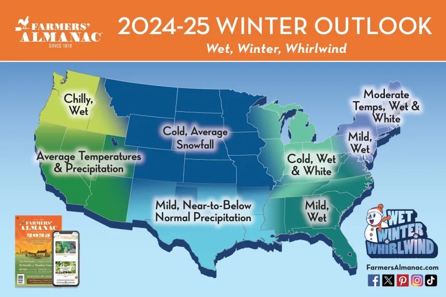
“We do see scorching temperatures with average rainfall, so hopefully, you won’t have to go into some type of drought, especially with the kind of wet seasons before that,” Duncan says. “It looks like average rainfall for next summer and hopefully you won’t get back into any type of drought conditions, since you guys need a little break, for sure.” Iowa’s had a rough spring and summer, with widespread flooding in many areas that followed severe storms, along with a record 130 tornadoes. Some point to climate change as the root cause, and Duncan says you’d have to be blind to say the climate isn’t changing.
“Definitely there’s something going on and things are changing, so we are trying to adapt to the ever-changing environment that we all live in,” Duncan says. “I would say that, unfortunately, this change that’s going on is bringing some more extreme weather, so we’re trying to adjust as we can and try to give people an idea of what may come so they can be prepared.” The Lewiston, Maine-based almanac boasts a forecast accuracy rate of 80% to 85%. The prognosticating formula was developed more than two centuries ago, based on factors including sunspot activity, planet positions, and the effect the Moon has on the Earth. Besides long-term weather predictions, the Farmers’ Almanac also contains a wealth of information on gardening, cooking, home remedies, folklore, managing your household, living in harmony with nature, and more.
Today: Showers and thunderstorms, mainly before 11am. High near 81. E/SE winds 15-25 mph. New rainfall amounts between a quarter and half of an inch possible.
Tonight: Showers and thunderstorms likely. Some of the storms could produce heavy rainfall. Low around 68. New rainfall amounts between 1 and 2 inches possible.
Tomorrow: A slight chance of afternoon showers & thunderstorms, otherwise mostly sunny. High near 84. W @ 5-10 mph.
Friday: Sunny, with a high near 82.
Saturday: Sunny, with a high near 83.
Sunday: Sunny, with a high near 84.
Tuesday’s High in Atlantic was 81. The Low was 65. We received .54″ rain this morning (up until 7-a.m.), here at KJAN. Last year on this date, the High in Atlantic was 72 and the Low was 53. The Record High here on Aug. 14th, was 107 in 1936. The Record Low was 45 in 1929. Sunrise today: 6:27-a.m.; Sunset: 8:21-p.m.
Today: Patchy dense fog/drizzle this morning reducing visibility to under 1 mile at times. Otherwise, mostly cloudy, with a high near 78. E/SE winds 5-10 mph.
Tonight: Mostly cloudy w/a 60% chance of showers & thunderstorms after midnight. Low around 64.
Tomorrow: Mo. cloudy w/a 60% chance of showers & thunderstorms. High near 82. SE winds @ 15-25 mph.
Tom. Night: Showers & thunderstorms. Low around 66.
Thursday: Partly sunny w/a slight chance of showers and thunderstorms. High near 82.
Friday: Sunny, with a high near 82.
Saturday: Sunny, with a high near 83.
Monday’s High in Atlantic was 71. The Low was 62. We received .02″ rain Monday (after 7-a.m.), here at KJAN. Last year on this date, the High in Atlantic was 78 and the Low was 58. The Record High here on Aug. 13th, was 101 in 1913. The Record Low was 39 in 1964. Sunrise today: 6:26-a.m.; Sunset: 8:23-p.m.
Today: Cloudy w/scattered showers & thunderstorms this morning & later this afternoon. High near 75. Winds East @ 5-10 mph.
Tonight: Isolated showers this evening. Patchy fog developing after midnight, otherwise mostly cloudy. Low around 59.
Tomorrow: Patchy fog before 7am. Otherwise, mostly cloudy, with a high near 78. East southeast wind 5 to 10 mph.
Tom. Night: A 70% chance of showers & thunderstorms. Low around 63.
Wednesday: A 40% chance of showers and thunderstorms through mid-day. High near 81.
Wed. Night: A 60% chance of showers & thunderstorms through midnight. Low around 66.
Thursday: Partly sunny w/a slight chance of afternoon showers and thunderstorms. High near 82.
Sunday’s High in Atlantic was 75. The Low was 52. We received .44″ rain Sunday night & until 7-a.m. today, at KJAN. Last year on this date, the High in Atlantic was 87 and the Low was 60. The Record High here on Aug. 12th, was 108 in 1936. The Record Low was 42 in 2004. Sunrise today: 6:25-a.m.; Sunset: 8:24-p.m.
Today: Partly sunny, with a high near 79. Calm wind becoming south southeast 5 to 10 mph this afternoon.
Tonight: Showers and thunderstorms developing late. Low around 59. New rainfall amounts between a half and three quarters of an inch possible.
Monday: Mostly cloudy w/showers & thunderstorms ending in the morning. High near 72. East winds 5-10 mph.
Monday Night: Mostly cloudy, with a low around 58.
Tuesday: Partly sunny, with a high near 77. E/SE winds 5-10.
Tue. Night: A 50% chance of showers & thunderstorms. Low around 61.
Wednesday: A 30% chance of showers & thunderstorms. High near 81.
Saturday’s High in Atlantic was 78. The Low was 44. Last year on this date, the High in Atlantic was 87 and the Low was 59. The Record High here on Aug. 11th, was 104 in 1894. The Record Low was 40 in 1902. Sunrise today: 6:24-a.m.; Sunset: 8:25-p.m.
GREENFIELD, Iowa (KCRG) – On May 21st, 2024, an EF 4 tornado spun a trail of destruction through Greenfield. Nearby wind turbines were bent in half and set on fire. Dr. Bill Gallus, a Professor of Meteorology at Iowa State University, told KCRG-TV, that in addition to the hot and humid air, which fueled the storms on that fateful Tuesday, a short distance between the storms may have strengthened the Greenfield tornado.
Dr. Gallus said there was another tornado that was only passing maybe 5 miles to the northwest of the Greenfield tornado, [and while their] instruments [were] not nearly close together enough to understand exactly what happened, he thinks there was probably some type of interaction happening with those two tornadic storms.
Engineers design wind turbines to withstand wind speeds up to 140 miles per hour. Meteorologist and engineer Tim Marshall kept that in mind as he watched video of the Greenfield tornado. Marshall said they would normally anticipate the turbine blades would shred, and that they would come apart in pieces and that’s exactly what happened. The tower which supports the turbine nacelle and blades was stronger.
Now, scientists are using their knowledge of meteorology and wind turbines to upgrade the EF Scale. Engineers such as Dr. Partha Sarkar, a professor of Aerospace Engineering at Iowa State University, are working to better understand how tornado winds impair wind turbines.
WINTERSET, Iowa — Movie theaters in Winterset and Greenfield say they are not planning on showing the movie “Twisters” this summer. KCCI in Des Moines reports the Iowa Theater in Winterset made the announcement Tuesday on Facebook. Manager Scott Smith said he watched the trailer and felt uncomfortable with what he saw.
On March 5, 2022, Iowa experienced one of the deadliest and most damaging tornado outbreaks the state had seen in years, including an EF4 tornado that touched down in Winterset. Smith said the images in the movie hit too close to home. He said many of the visuals looked too similar to what happened in Greenfield this spring. A deadly EF4 tornado tore through the town located 25 miles west of Winterset in May, killing four people and injuring dozens more.
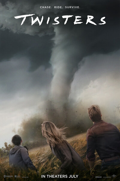
Movie poster for “Twisters”
In a statement made to KCCI, the manager of the Grand Theater in Greenfield, Deb Lundy, said: “The Grand Theater had been planning to show the Twisters movie since the beginning of the year. When the tornado hit us, I called my movie broker and between the two of us we decided it was not the right time for us to show that movie.”
Today: Mostly sunny, with a high near 73. Northwest wind 10 to 20 mph.
Tonight: Mostly clear, with a low around 48.
Tomorrow: Sunny, with a high near 77. Winds becoming West at 5 to 10 mph in the afternoon.
Tom. Night: Partly cloudy, with a low around 54.
Sunday: Mostly cloudy w/a 20% chance of showers. High near 73.
Sunday Night: Cloudy w/a 40% chance of showers and thunderstorms. Low around 58.
Monday: Mostly cloudy, with a high near 76.
Tuesday: Mostly cloudy, with a high near 79.
Thursday’s High in Atlantic was 76. Our Low this morning was 50. Last year on this date, the High in Atlantic was 81 and the Low was 57. The Record High here on Aug. 9th, was 111 in 1934. The Record Low was 44 in 1927. Sunrise today: 6:22-a.m.; Sunset: 8:28-p.m.


