
(Radio Iowa) – It appears the long-running drought in western Iowa will continue running well into 2022 as experts predict below-normal flows for the Missouri River basin this spring and summer. Doug Kluck, the Central Region climate service director for the National Weather Service, says soil moisture levels are well under average across the entire region.
“It’s all below normal, pretty much everywhere,” Kluck says. “Portions of the Dakotas have a little bit of soil moisture in them but going into spring, we’re really focusing on getting help from spring rainfall at this point. Fall and winter didn’t help us out.” Kluck predicts temperatures from March through May will be warmer than the norm.
“Better chances for above-normal temperatures, although slight, across almost the entire basin,” Kluck says. “Upper basin actually has a little bit of weak signature towards cooler-than-normal temperatures in the far northwest and then warm once you get halfway through South Dakota, Wyoming, all the way through the south and east of there.” Kluck says he’s concerned about the worsening dry conditions across the region.
“What we don’t like seeing but is typical of a La Nina year on the precipitation outlook is this below-normal forecast sneaking up from the south and southwest,” he says. According to Kluck, the mountain snowpack, which feeds into the basin, is about 80-percent of normal.
Today: Partly cloudy. High 30. NW @ 15-25.
Tonight: Mostly clear. Low around 0.
Tomorrow: P/Cldy. High 36. SW @ 10-15 mph.
Sunday: P/Cldy. High 57.
Monday: P/Cldy to cldy. High 50.
Thursday’s High was 23. Our Low this morning was 14. We received .1′ of snow, Thursday, at KJAN. Last year on this date the High in Atlantic was 57 and the Low was 28. The Record High on this date was 69 in 1900. The Record Low was -22 in 1948.
Today: **Winter Weather Advisory for snow in effect until 6-p.m.** A chance of light snow, mainly before 1pm. Cloudy, with a high near 28. Wind N @ 10-15. Windchill values as low as 5. Less than 1/2 inch of snow accumulation is expected.
Tonight: Fair to Partly cloudy, with a low around 10. Wind light & variable.
Tomorrow: P/Cldy. High 28. NW @ 10-20 mph.
Saturday: P/Cldy. High around 36.
Sunday: P/Cldy. High 52.
Wednesday’s High in Atlantic was 28. The 24-hour Low (as of 4-a.m. today), was 19. Last year on this date the High in Atlantic was 76 and the Low was 32. The Record High on this date was 76 in 2021. The Record Low was -8 in 1948.
Today: Partly cloudy to cloudy. High 33. N wind 10 to 15 mph.
Tonight: (Winter Weather Advisory begins at 6-p.m.) Mostly cloudy w/light snow overnight. Low around 11. N @ 5-10, Wind chill values as low as zero.
Thursday: Snow (ending by around mid-day) (around 1″ total). High 28. NE @ 10-15.
Friday: P/Cldy. High 28.
Saturday: P/Cldy. High around 38.
Tuesday’s High in Atlantic was 46. Our Low was 15. Last year on this date the High in Atlantic was 73 and the Low was 48. The Record High on this date was 76 in 1986. The Record Low was -10 in 1912.
Today: Mostly sunny. High 46. SW @ 10-15.
Tonight: P/Cldy. Low 22. N @ 5-10.
Tomorrow: Mo. Cldy. High 35. N @ 10-15.
Thursday: Mo. Cldy w/light snow. High 28.
Friday: P/Cldy. High near 30.
Monday’s High in Atlantic was 32. Our Low this morning, 14. Last year on this date the High in Atlantic was 69 and the Low was 34. The Record High on this date was 76 in 1986. The Record Low was -12 in 1982.
NWS DAMAGE SURVEY EFFORTS ARE ONGOING AT THIS TIME. PRELIMINARY SURVEY RESULTS FROM NEAR WINTERSET NORTHEAST INTO TAMA COUNTY WILL NOT BE AVAILABLE UNTIL LATER TODAY (Monday)..
NOTE:
THE INFORMATION IN THIS STATEMENT IS PRELIMINARY AND SUBJECT TO CHANGE PENDING FINAL REVIEW OF THE EVENT AND PUBLICATION IN NWS STORM DATA.
GARDEN GROVE/HUMESTON TORNADO…
EF-2 TORNADO DEVELOPED JUST NORTHEAST OF LEON AND CONTINUED NORTHEAST, GRAZING GARDEN GROVE AND HUMESTON BEFORE ENDING JUST NORTHEAST OF DERBY IN LUCAS COUNTY.
ESTIMATED PEAK WIND: 122 MPH; PATH LENGTH /STATUTE/: 19.1 MILES; PATH WIDTH /MAXIMUM/: TBD
FATALITIES: 0; INJURIES: 0
START DATE: 3/5/2022, START TIME: 507 PM, START LOCATION: 2.1 MILES NORTHEAST OF LEON;
END DATE: 3/5/2-22, END TIME: 534 PM, END LOCATION: 1.2 MILES EAST OF DERBY
CHARITON/RED HAW STATE PARK TORNADO…
EF-3 TORNADO DEVELOPED AS THE PREVIOUS TORNADO WEAKENED NEAR DERBY. THE TORNADO TRACKED JUST SOUTH OF CHARITON, TAKING A DIRECT PATH THROUGH RED HAW STATE PARK.
ESTIMATED PEAK WIND: 138 MPH; PATH LENGTH /STATUTE/: 16.5 MILES; PATH WIDTH /MAXIMUM/: TBD
FATALITIES: 1, INJURIES: 1
START DATE: 3/5/2022, START TIME: 530 PM, START LOCATION: 2.4 MILES SOUTH OF DERBY
END DATE: 3/5/2022, END TIME: 554 PM, END LOCATION: 5.5 MILES EAST OF CHARITON
ALLERTON/CORYDON TORNADO…
AN EF-2 TORNADO DEVELOPED JUST SOUTHWEST OF ALLERTON AND SKIRTED THE SOUTHEAST EDGE OF THE COMMUNITY. THE TORNADO THEN TRACKED NORTHEAST, EVENTUALLY PASSING JUST EAST OF CORYDON.
ESTIMATED PEAK WIND: 118 MPH; PATH LENGTH /STATUTE/: 7.5 MILES; PATH WIDTH /MAXIMUM/: TBD
FATALITIES: 0, INJURIES: 0
START DATE: 3/5/2022, START TIME: 538 PM, START LOCATION: 1.5 MILES SOUTHWEST OF ALLERTON
END DATE: 3/5/2022, END TIME: 548 PM, END LOCATION: 2 MILES EAST OF CORYDON
***********
EF SCALE: THE ENHANCED FUJITA SCALE CLASSIFIES
TORNADOES INTO THE FOLLOWING CATAGORIES.
EF0…WEAK……65 TO 85 MPH
EF1…WEAK……86 TO 110 MPH
EF2…STRONG….111 TO 135 MPH
EF3…STRONG….136 TO 165 MPH
EF4…VIOLENT…166 TO 200 MPH
EF5…VIOLENT…>200 MPH
(Radio Iowa) – Madison County residents and volunteers will continue clean up today (Monday) from a deadly weekend tornado on the south edge of Winterset that killed six people. Volunteers with equipment and chain saws were helping clean up Sunday at the home of Teresa Hoag off Highway 169. She said her husband was going out to pull the car in the garage when the tornado hit Saturday evening. “And as he opened the door, I could see it, I could hear it over the hill,” She says. Hoag said she saw dark angry-looking clouds and it all happened very quickly. “Started hearing the crashing and booming and the wind – and then it was over,” Hoag says.
Her husband Don said he was trying to get the car out of the hail when he heard the tornado. “A train was coming down the road, it sounded like a train just coming. As soon as I got in the house, and around the corner, we had big tall pine trees in our yard and I just watch them take off. And then the door came in,” Hoag said. They lost seven outbuildings and the upper portion of their log home blew off. Don Hoag said it was much worse for their neighbors across the road. “As soon as I got my bearings and looked outside and everything was gone, I knew they were in trouble, and I ran, and Judy was crying, and she was by her husband,” Hoag said.
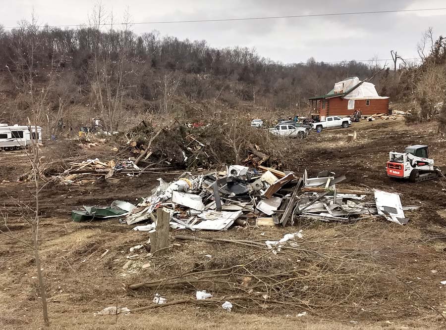
The home of Teresa & Don Hoah near Winterset
Their neighbor — 67-year-old Rodney Clark — was one of the people who died. Hoag said a large pile of rubble in front of his home is all that is left of the Clark’s house. There are bits of pink insulation hanging from the branches of the trees left standing around their home. The other victims of the Winterstet tornado were identified as 63-year-old Melissa Bazley, 72-year-old Cecilia Lloyd, 37-year-old Michael Bolger, five-year-old Kinley Bolger, and two-year-old Owen Bolger. The Hoag’s were overwhelmed by the people who turned out to clear trees and debris from around their home. A fundraising page has been established for the Bolger family.
“We’ve a lot of friends and family, and people we don’t even know out here helping,” Teresa Hoag said.
Governor Kim Reynolds toured the area and also commented on the people who showed up to help. “Two-hundred to 300 Iowans. Not only from Madison County and Winterset — but from communities and towns all across the state — that were on the ground the minute it was light and they could start helping,” the governor said. “It’s just unbelievable. I tried to walk through and thank them and over and over the response was “we’re Iowans and that’s what we do’.”
Madison County Emergency Management Coordinator, Diogenes Ayala had more details on the storm. “The National Weather Service determined that the tornado that tore through our community was estimated to be an E-F-3. With wind speeds between 136 miles and 155 miles per hour. There were approximately 52 damaged or destroyed homes in the path of the tornado that spanned over 13-point-seven miles,” according to Ayala.
The governor issued a disaster proclamation for Madison County. The Iowa Department of Natural Resources confirms one person died in the storm Saturday at Red Haw State Park in Chariton. The park had extensive damage and will be closed until further notice.
Today: (Winter Weather Advisory until 8-a.m.) Light snow ending (< than 1/2″ additional accumulation); Becoming partly cloudy. High 33. NW @ 10-20.Wind chill values as low as 10.
Tonight: Fair to P/Cldy. Low around 12. Winds becoming light and variable.
Tomorrow: P/Cldy. High 46. SW @ 10-20. Wind chill values as low as 10 early.
Wednesday: P/Cldy. High 37.
Thursday: Cloudy w/a chance of snow. High near 28.
Sunday’s High in Atlantic was 34. Our Low this morning, 23. We received 1.3″ of snow overnight at KJAN (up until 5-a.m.). Last year on this date, the High in Atlantic was 68, and the Low was 34. The Record High was 78 in 2000. The Record Low was -11, in 1982.
Today: A chance of rain and snow, mainly after 5pm. Increasing clouds, with a high near 39. Northwest wind 10 to 15 mph, with gusts as high as 23 mph. Chance of precipitation is 40%. Little or no snow accumulation expected.
Tonight: Snow likely, mainly before 4am. Cloudy, with a low around 19. North northwest wind 9 to 13 mph, with gusts as high as 18 mph. Chance of precipitation is 60%. New snow accumulation of 1 to 3 inches possible.
Monday: Mostly cloudy through mid morning, then gradual clearing, with a high near 36. Wind chill values as low as 10. North northwest wind 8 to 14 mph, with gusts as high as 21 mph.
Tuesday: Sunny, with a high near 47. South southwest wind 6 to 15 mph, with gusts as high as 24 mph.
Wednesday: Partly sunny, with a high near 39.
Saturday’s High in Atlantic was 63. Our Low this morning, 25. We received .13″ of rain during the day, Saturday. Last year on this date, the High in Atlantic was 65, and the Low was 25. The Record High was 76 in 2017. The Record Low was -20, in 1960.


