
256 AM CDT Fri Mar 18 2022
Rain has changed to snow across the advisory area this morning and continue through the day. Roads may become snow or slush covered at times causing slick conditions to develop.
Guthrie-Dallas-Cass-Adair-Madison-Adams-Union-Taylor Counties
…WINTER WEATHER ADVISORY REMAINS IN EFFECT UNTIL 4 PM CDT THIS AFTERNOON…
* WHAT…Snow expected. Total snow accumulations of 1 to 4 inches. Locally higher amounts on grassy or elevated surfaces may occur. The wind will gust as high as 35 mph.
* IMPACTS…Plan on snow or slush covered roadways and slippery road conditions. The hazardous conditions could impact this mornings commute.
PRECAUTIONARY/PREPAREDNESS ACTIONS…
Slow down and use caution while traveling. For the latest travel conditions, check the Iowa 511 app, www.511ia.org or dial 511.
(Radio Iowa) – Parts of western Iowa are again in “severe drought” and extremely low soil moisture levels may linger even longer, as the National Climate Prediction Center is now forecasting the current La Nina will last well into summer. Meteorologist Dennis Todey, director of the U-S-D-A’s Midwest Climate Hub in Ames, says that could extend a serious worry for Iowa farmers as planting season nears.
“If we were in relatively decent shape soil moisture-wise right now, I wouldn’t be as concerned, but given that we have dry conditions and that we’re not seeing big help so far this spring, that’s what has me concerned,” Todey says. “Any increase in chances that the drought continues is going to be a problem.” Todey says much of the region is heading into spring with very dry soil and the C-P-C is forecasting drought areas may expand across the Central Plains into spring. 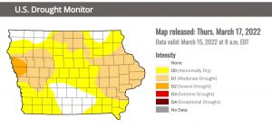
“Originally the thought was that La Nina was going to continue weakening this spring and would not be in effect in the summertime,” Todey says. “Some of the models are hinting that this La Nina could last, maybe not strongly, but last into the summer.” The latest map from the U-S Drought Monitor shows roughly 45 Iowa counties are in the category of abnormally dry, with about 36 counties in moderate drought.
Large sections of Monona and Woodbury counties are now listed as “severe drought,” while there are only around 16 counties where soil moisture levels are considered normal.
Today: Mostly cloudy w/a chance of sprinkles this morning, & light rain this afternoon. High 53. NE @ 10-15 mph.
Tonight: Cloudy w/ rain becoming mixed w/snow late. Low around 34. NW @ 10-15.
Tomorrow: Cloudy w/a snow-rain mix through mid-day. High near 40. N @ 10-20.
Saturday: P/Cldy. High near 58.
Sunday: P/Cldy & warmer. High near 70.
Wednesday’s High in Atlantic was 73. Our Low was 34.
Wednesday’s High in Atlantic was 75. Our Low this morning, 29. Last year on this date the High in Atlantic was 39 and the Low was 32. The Record High on this date was 84 in 1894. The Record Low was -11 in 1906.
Today:Partly cloudy. High 72. SW @ 10-20 mph.
Tonight: P/Cldy. Low around 40. South wind 5 to 10 mph.
Tomorrow: P/Cldy w/light rain. High 55. N @ 5-10.
Friday: Mo. Cldy w/light rain-snow early. High 45.
Saturday: P/Cldy. High 56.
Tuesday’s High in Atlantic was 57. Our Low was 25. Last year on this date the High in Atlantic was 46 and the Low was 35. The Record High on this date was 84 in 2015. The Record Low was -4 in 1900.
(Radio Iowa) – Both of Iowa’s U.S. Senators and two Iowa congresswomen are asking for answers AND upgrades after reports of technical delays in the National Weather Service warnings of severe storms that killed seven Iowans earlier this month.
Congresswomen Cindy Axne of West Des Moines and Ashley Hinson of Marion have written the acting director of the National Weather Service. They’re asking for an explanation of the problem in the Dallas/Fort Worth office that delayed release of Iowa tornado warnings on March 5th. Axne and Hinson say the delays are unacceptable and addressing them should be the highest priority. Iowa Senators Chuck Grassley and Joni Ernst are co-sponsoring a bill to update forecasting technology and communications equipment in the National Weather Service.
The delays in tornado warnings on March 5th were due primarily to a damaged fiber optic cable. National Weather Service staff came up with a work around and a warning that a tornado was likely to hit near Winterset was issued 20 minutes in advance.
Today: Patchy fog this morning; Partly cloudy. High near 60. NW-SW winds at 10.
Tonight: Fair to P/Cldy. Low around 35. South wind 5 to 10 mph.
Wednesday: P/Cldy to Cldy. High 72. SW @ 10-20.
Thursday: P/Cldy to Cldy w/a chance of light rain. High 57.
Friday: P/Cldy to Cldy w/a chance of light rain in the morning. High 48.
Monday’s High in Atlantic was 59. Our Low this morning was 27. Last year on this date, the High was 38 and the Low was 35. The Record High on March 15th in Atlantic, was 79 in 2003, and the Record Low was 0 in 1944.
(Radio Iowa) – The experts are still studying the series of ten tornadoes that touched down in Iowa on March 5th, claiming seven lives and damaging or destroying dozens of houses. Meteorologist Dennis Todey, director of the U-S-D-A’s Midwest Climate Hub in Ames, says the strength of the tornadoes was very unusual, as they included a pair of E-F-2s, an E-F-3 and an E-F-4.
Todey says, “Small tornadoes in March is not a surprise, too much, but something of this nature and several of them, the total is up to ten now that the Weather Service has confirmed related to this, is really more than we want to see at this point.” Forecasters are trying to determine if this is a sign of more frequent early-season severe weather. “I don’t know that we can take it as a signal for anything larger just yet,” Todey says, “but it is also an example of a typical spring kind of thing where you get some severe weather ahead of a big system and then cold air and snow behind it.”
Temperatures in parts of Iowa that day were in the 60s and 70s, then the late afternoon storm brought tornadoes and hail, followed the next day by highs only in the 20s and 30s and several inches of snow. That clash of large masses of warm and cold air, Todey says, is textbook for tornadoes.
“The jet stream itself is starting to work its way back northward from being in the southern U.S. during the winter,” Todey says, “so that boundary between the warm air and cold air is more in the middle of the country now and we’re able to get more warm air and moisture further northward more readily.” That can be a recipe for severe weather. Iowa also saw a massive outbreak of tornadoes during the derecho in mid-December, which was very rare.
Today: P/Cldy. High near 60. SE-NW wind at 10-15 mph.
Tonight: P/Cldy. Low 28. NW @ 5-10.
Tomorrow: P/Cldy. High 58. NW-SW @ 10.
Wednesday: P/Cldy. High 70.
Thursday: Mo. Cldy w/scattered light showers. High 53.
Sunday’s High in Atlantic was 61. Our Low was 21. Last year on this date the High in Atlantic was 44 and the Low was 33. The Record High on this date was 78 in 2012. The Record Low was -12 in 1975.
Today: Sunny, with a high near 60. Calm wind becoming south southeast 5 to 9 mph in the afternoon.
Tonight: Partly cloudy, with a low around 33. South wind 7 to 10 mph, with gusts as high as 22 mph.
Monday: Partly sunny, with a high near 56. South wind 6 to 10 mph becoming north northwest in the afternoon. Winds could gust as high as 21 mph.
Tuesday: Mostly sunny, with a high near 58. Calm wind becoming south southwest 5 to 9 mph in the afternoon.
Wednesday: Mostly sunny, with a high near 67. Breezy.
Saturday’s High in Atlantic was 32. Our Low was 1. Last year on this date the High in Atlantic was 58 and the Low was 24. The Record High on this date was 79 in 2012. The Record Low was -11 in 1948 & 1975.
Today: Partly-to-Mostly sunny. High 36. SW @ 10-15.
Tonight: Partly cloudy. Low 28. SW @ 5-10.
Tomorrow: P/Cldy. High near 60. SW @ 10-20 mph.
Monday: Mostly cloudy. High 52.
Tuesday: P/Cldy. High 55.
Friday’s High in Atlantic was 25. Our 24-hour Low (ending at 7-a.m.) was 1 degree. Last year on this date the High in Atlantic was 51 and the Low was 24. The Record High on this date was 74 in 1938. The Record Low was -21 in 1998.


