
Today: P/Cldy to Cldy w/spotty light rain or flurries. High around 42. NW winds @ 20-40.
Tonight: Light rain/flurries ending; Mostly cloudy. Low 32. NW@ 13-30.
Tomorrow: P/Cldy to Cldy. High 48. N@ 15-30.
Saturday: Mo. Sunny. High near 60.
Sunday: P/Cldy. High 68.
Wednesday’s High in Atlantic was 51. Our Low this morning, 37. We received a Trace of rain, Wednesday. Last year on this date the High in Atlantic was 66 and the Low was 47. The Record High on this date was 85 in 2020. The Record Low was 10 in 2018.
(Update NWS/Omaha, 3:25-a.m. 4/7/22)
Shelby-Pottawattamie Counties….WIND ADVISORY IN EFFECT today from 7-a.m. until 9-p.m.; for Monona & Harrison Counties, the Advisory remains in effect through 9-p.m.
* WHAT…Northwest winds 25 to 35 mph with gusts up to 55 mph expected.
* IMPACTS…Gusty winds could blow around unsecured objects. Tree limbs could be blown down and a few power outages may result. 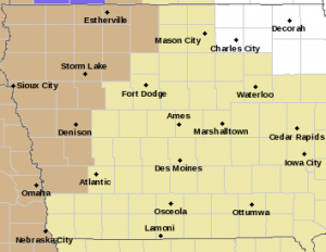
PRECAUTIONARY/PREPAREDNESS ACTIONS…
Use extra caution when driving, especially if operating a high profile vehicle. Secure outdoor objects.
Crawford County……WIND ADVISORY IN EFFECT FROM 7 AM TODAY TO 7 PM THURSDAY.
Harrison County….WIND ADVISORY IN EFFECT TODAY FROM 7 AM TO 7 PM, & ON THURSDAY FROM 5-A.M. TO 7-P.M.
* WHAT…For the first Wind Advisory, northwest winds 25 to 35 mph with gusts up to 45 mph expected. For the second Wind Advisory, northwest winds 25 to 35 mph with gusts up to 50 mph
expected.
* IMPACTS…Gusty winds could blow around unsecured objects. Tree limbs could be blown down and a few power outages may result.
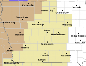
Wind Advisory for counties in light brown/tan.
Shelby-Pottawattamie Counties….WIND ADVISORY IN EFFECT ON THURSDAY FROM 5 AM TO 7 PM...
* WHAT…Northwest winds 25 to 30 mph with gusts up to 45 mph expected.
PRECAUTIONARY/PREPAREDNESS ACTIONS…
Use extra caution when driving, especially if operating a high profile vehicle. Secure outdoor objects.
Today: P/Cldy to Cldy w/spotty light rain. High 53.W-NW @ 20-35 mph.
Tonight: Light rain ending; becoming P/Cldy. Low 37. NW @ 10-20.
Tomorrow: P/Cldy to Cldy w/a chance of flurries or light rain. High 40. NW@ 20-35.
Friday: P/Cldy to Cldy. High around 48.
Saturday: Mostly sunny. High near 60.
Tuesday’s High in Atlantic was 59. Our Low was 38. We received .01″ of rain Tuesday at KJAN. Last year on this date the High in Atlantic was 78 and the Low was 57. The Record High on this date was 89 in 1972. The Record Low was 6 in 1982.
Council Bluffs, Iowa – The Pottawattamie County Emergency Management Agency says a ban on open burning will be in place for Pottawattamie County beginning Wednesday, April 6, 2022, at 8:00 a.m.
The ban prohibits all open and controlled burning in Pottawattamie County, including all incorporated city limits within the county. The current weather forecast and environmental conditions indicate a very high fire danger with winds gusting to over 40 mph over the next couple days. The current dry conditions and dead vegetative fuels creates the perfect conditions for fires to spread rapidly. 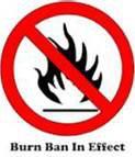
Fire departments within the county have been responding to increased controlled burns that have gotten out of control, endangering property. During these dry conditions, citizens are reminded to not throw out cigarettes from moving vehicles and to discontinue burning yard waste, piled tree debris, grass/agricultural ground and set-asides or other items during the ban. At this time, the ban is anticipated to remain in effect until after planting season or if the county receives substantial increases in precipitation.
Violation of a burn ban can subject a person to citation or arrest for reckless use of fire or disobeying a burn ban. You may also be liable for any damages, losses, or injuries resulting from the fire.
For updated information on burn bans and the law you can find further information on our facebook, twitter, and web page. All citizens are urged to sign up for Alert Iowa at pcema-ia.org to receive alerts for fire danger, severe weather, and emergency notifications for your community.
Today: P/Cldy to Cldy w/scattered showers. High 57 S winds @ 10-20 becoming NW late.
Tonight: Rain ending in the evening; becoming P/Cldy. Low 35. NW-SW @ 10-15.
Tomorrow: P/Cldy to Cldy w/a chance of afternoon showers. High 53. NW@ 10-20.
Thursday: Mo. Cldy, windy & cooler, w/scattered showers & possible flurries. High 40.
Friday: P/Cldy to Cldy. High 48.
Monday’s High in Atlantic was 59. Our Low was 31. Last year on this date the High in Atlantic was 83 and the Low was 59. The Record High on this date was 88 in 2000. The Record Low was 14 in 1920.
(Radio Iowa) – March proved to be a mixed bag when it came to temperatures and precipitation. State Climatologist Justin Glisan says things were slightly wetter than normal. “Precipitation we were above average across much of the state — seven-tenths of an inch preliminarily. Typically we receive about two inches of snowfall and rainfall during March — above-average totals in the southeast two-thirds of the state,” Glisan says. He says there wasn’t anything too out of the ordinary in the temperatures for March. “It was near average when you look at temperatures statewide. We were about 36 degrees for the average temperature there,” Glisan says. “We did have pockets of above-average temperatures in north-central and southeastern Iowa — but basically what we would expect climatologically on the temperature side.”
Glisan says the most notable weather occurrence in March was the deadly tornadoes. “We lost seven individuals form two supercells spawned tornadoes in southern Iowa. This was the highest fatality count we had since the Parkersburg E-F-5 in 2008,” he says. “And it was the first E-F-4 tornado this far north, this early in March.” Glisan says the outlook for this month could give us some April showers “We have actually seen a shift in the precipitation field from the initial outlook issued in the middle of March. And we are seeing a slightly elevated signal for wetter conditions across the state — which would be beneficial in terms of drought conditions. Now we don’t want to get too wet to keep farmers out of the fields, but this is a good signal to have,” according to Glisan.
He says the signals for the temperature are not showing any trend toward warmer or cooler conditions at this point for April.
Today: Partly cloudy. High 55. NW winds @ 10-20 becoming SE this afternoon & diminishing late.
Tonight: P/Cldy. Low 36. SE @ 5-10.
Tomorrow: P/Cldy to Cldy w/showers. High around 55. S winds @ 10-20 in the morning becoming NW in the afternoon.
Wednesday: P/Cldy to Cldy. High 53.
Thursday: Mo. Cldy w/scattered light rain. High 45.
Sunday’s High in Atlantic was 52. Our low was 28. We received .13″ rain. Last year on this date the High was 85 and the Low was 34. The Record High in Atlantic on April 4th was 91 in 1929, & the Record Low was 4, in 1899.
Today: A chance of rain and thunderstorms. Mostly cloudy, with a high near 60. East southeast wind 7 to 14 mph becoming southwest in the afternoon. Winds could gust as high as 21 mph. Chance of precipitation is 30%. New rainfall amounts of less than a tenth of an inch, except higher amounts possible in thunderstorms.
Tonight: A 10 percent chance of rain before 7pm. Mostly cloudy, then gradually becoming mostly clear, with a low around 33. Breezy, with a west southwest wind 8 to 17 mph becoming northwest after midnight. Winds could gust as high as 29 mph.
Monday: Mostly sunny, with a high near 55. North wind 5 to 13 mph, with gusts as high as 21 mph.
Tuesday: A 50 percent chance of rain, mainly after 1pm. Mostly cloudy, with a high near 62. Breezy, with a south southeast wind 13 to 16 mph becoming west southwest in the afternoon. Winds could gust as high as 24 mph. New precipitation amounts of less than a tenth of an inch possible.
Tuesday Night: A 30 percent chance of rain before 1am. Mostly cloudy, with a low around 35. New precipitation amounts of less than a tenth of an inch possible.
Wednesday: A 20 percent chance of rain after 1pm. Mostly sunny, with a high near 55. Windy.
Saturday’s High in Atlantic (@KJAN), was 60. Our Low this morning, 26.
Skyscan Forecast Saturday, April 2, 2022 Dan Hicks
Today: Mostly cloudy early then becoming partly cloudy. N @ 10-20. High 56.
Tonight: Fair to partly cloudy. Light and variable winds. Low 30.
Sunday: Partly cloudy to cloudy. A few afternoon showers possible. S @ 10-20. High 60.
Sunday Night: Partly cloudy. W @ 5-10. Low 33.
Monday: Partly cloudy. High 58.
Tuesday: Mostly cloudy. A few showers developing. High 58.
Yesterday’s high was 57 and the low was 15. This day last year the high was 69 and the low was 35. The all-time record high for today was 88 set in 2012. The record low was 13 in 1970. Sunrise this morning is 7:01 a.m. and sunset will be at 7:46 p.m.


