
Today: Partly to Mostly Cloudy a chance of scattered light rain this morning. High 46. NW @ 20-35 mph.
Tonight: P/Cldy w/diminishing winds. Low 28. W @ 10-20.
Tomorrow: P/Cldy & windy. High near 50. W @ 15-30.
Friday: Mostly cloudy. High 47.
Saturday: P/Cldy. High near 50.
Tuesday’s High in Atlantic of 85 was just 1 degree shy of tying the record set in 1916. We received .46″ rain Tue. night, along with pea size hail. Our Low this morning, 38. Last year on this date the High in Atlantic was 54 and the Low was 27. The Record High on this date was 88 in 2006. The Record Low was 11 in 1950.
(Omaha/Valley, NE) – The National Weather Service is compiling information with regard to the severe storms that passed through Nebraska and Iowa, Tuesday evening and Tuesday night. In this area:
There were numerous reports of tornadoes or funnel clouds out of northwest and north central Iowa, including near Gilmore City and Humboldt, along with large hail. Gilmore City had tennis ball size (2.5″ hail at around 6:48-p.m. There were many reports of winds near or in excess of 70-p.m. at the line of intense storms passed through the state.
Today: A 30 percent chance of showers, mainly between 10am and 1pm. Cloudy, then gradually becoming mostly sunny, with a high near 77. Windy, with a southeast wind 21 to 25 mph, with gusts as high as 38 mph.
Tonight: Showers and thunderstorms before 4am, then a chance of showers. Some of the storms could produce heavy rainfall. Low around 37. Windy, with a south wind 23 to 28 mph becoming west northwest 17 to 22 mph after midnight. Winds could gust as high as 39 mph. Chance of precipitation is 90%. New rainfall amounts between a half and three quarters of an inch possible.
Wednesday: A chance of showers and thunderstorms before 10am, then a slight chance of showers between 10am and 1pm. Mostly sunny, with a high near 49. Windy, with a west northwest wind 14 to 21 mph, with gusts as high as 28 mph. Chance of precipitation is 30%. New precipitation amounts of less than a tenth of an inch, except higher amounts possible in thunderstorms.
Thursday: Sunny, with a high near 50. Windy.
Friday: Mostly sunny, with a high near 52.
(Radio Iowa) – The University of Iowa has been selected to be a partner in a 360 million dollar national consortium to work on improving flood predictions. The U-I’s Larry Weber will lead the effort in Iowa and says they will build on what they have done here to combat flooding. “The Iowa flood information system that we’ve created for the state of Iowa, has been recognized by people across the country as the best in class and information for flooding. And we’ll be expanding that I will flood information system to the Upper Mississippi River Basin and the Mississippi River basin, and then eventually the entire nation,” Weber says.
Weber leads the university’s Hydroscience and Engineering program and says they have deployed sensors across the state while also developing new sensor technology to help in the monitoring of the onset of flooding. This technology will not get broader use. “Sharing that technology with other partners that then could deploy similar technology in their own states,” he says. He says they will also work on other areas of flooding. “A second area that will have a lot of work is going to be in creating new technologies for fast and reliable floodplain mapping. So providing those recurrence level maps for the 100-year flood, and that 500-year flood and floods in between,” Weber says.
Weber says water quality is something that’s included in the project along with the flood monitoring and floodplain maps. “The Weather Service is quite interested in working with their federal partners, to begin to create a real-time water quality forecast model for rivers and streams in the nation,” according to Weber. “And given the strength of our work here in Iowa and that area, we think that will contribute to that strongly as well.” Weber says there are different types of flooding across the country that they will be dealing with. “In our steeper mountainous streams, we get more flash flooding. So we may get rainfall that produces a flood, you know, that that that comes up in a matter of minutes or hours. That’s really quite different. Along a coastline, we get compound flooding, where we have storm surge from the ocean or from the Gulf, that provides a bottleneck to the rivers that are flowing to the ocean to the Gulf,” he says.
That bottleneck can lead to flooding. The five-year program will be headquartered at the University of Alabama. It is funded for five years by the National Oceanic and Atmospheric Administration and Iowa will receive 21 million dollars for its portion of the work.
Today: Partly cloudy, High 62. NW-S @ 5-10 mph.
Tonight: Fair to P/Cldy. Low 40. S @ 5-10,
Tomorrow: P/Cldy w/scattered showers and thunderstorms. High 70. S @ 10-20.
Wednesday: Mo. Cldy w/showers. High 52.
Thursday: P/Cldy. High 48.
Sunday’s High in Atlantic was 52. Our Low was 30. Last year on this date the High in Atlantic was 69 and the Low was 32. The Record High on this date was 91 in 1996. The Record Low was 18 in 1956 & 2004.
Today: Partly sunny, with a high near 67. Breezy, with an east southeast wind 16 to 20 mph becoming west in the afternoon. Winds could gust as high as 28 mph.
Tonight: Partly cloudy, with a low around 35. Breezy, with a west northwest wind 13 to 18 mph decreasing to 6 to 11 mph after midnight. Winds could gust as high as 22 mph.
Monday: Mostly sunny, with a high near 61. Calm wind becoming west southwest 5 to 8 mph in the morning.
Tuesday: A chance of showers and thunderstorms before 11am, then a chance of showers between 11am and 2pm, then a chance of showers and thunderstorms after 2pm. Mostly cloudy, with a high near 71. Windy, with an east southeast wind 15 to 23 mph, with gusts as high as 33 mph. Chance of precipitation is 40%. New rainfall amounts of less than a tenth of an inch, except higher amounts possible in thunderstorms.
Tuesday Night: A 50 percent chance of showers and thunderstorms. Partly cloudy, with a low around 51. Windy. New rainfall amounts between a tenth and quarter of an inch, except higher amounts possible in thunderstorms.
Wednesday: A 40 percent chance of showers. Partly sunny, with a high near 59. Windy.
Saturday’s High in Atlantic was 61. Our Low was 19. Last year on this date the High in Atlantic was 62 and the Low was 32. The Record High on this date was 94 in 1930. The Record Low was 17 in 1989.
Today: Mostly sunny. High near 60. S winds @ 10.
Tonight: P/Cldy. Low 38. S @ 5-10.
Tomorrow: P/Cldy. High 68. S@ 10-20.
Monday: P/Cldy. High near 60.
Tuesday: P/Cldy w/a chance of afternoon showers & thunderstorms. High near 70.
Friday’s High in Atlantic was 52. Our Low this morning was 18. Last year on this date the High in Atlantic was 59 and the Low was 45. The Record High on this date was 85 in 1977. The Record Low was 14 in 2016.
(Radio Iowa) – A majority of Iowa remains in dry or drought conditions — but things have improved quite a bit in the last month. The D-N-R’s Tim Hall tracks the water summary. “You compare the drought monitor map from early March to late March — we saw significant improvement. At the beginning of March, about 90 percent of the state was rated in some form of dryness and drought — now we are down to 60 percent,” according to Hall. He says turning things around is not a quick process. “You have to remember that the drought that we came through last year that we are still kind of working out way of, was so deeply entrenched in that state that it’s just going to take awhile to slowly dig ourselves out of those precipitation deficits we’ve been at,” according to Hall. He says the driest areas start in central Iowa and move east and north.
“Up toward Cedar Rapids and Waterloo, up toward northeast Iowa, sort of that east-central part of the state they’ve had some pretty good rainfall over the last month. Northeast Iowa has been pretty wet, in fact we saw some reductions in the Drought Monitor just in that east-central, northeast Iowa location just in the last week or two,” he says. “So, they’re getting what they need in that part of the state.” There are still some areas to the west that could use more rain as they have D-2 or severe drought. “In Monona and Pottawattamie County in western Iowa, just about two percent of the state. That’s a little bit troubling to see that creep in, because that’s a part of the state where we’ve had some drought challenges in the past,” he says. Hall says the increased rainfall hasn’t caused any problems. 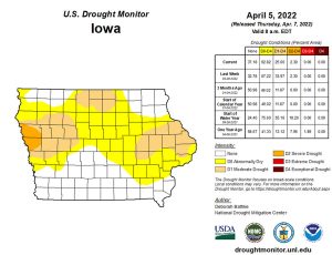
“We have not seen any substantial flooding this spring, which is a great thing for us not to have. And it kind of indicates that the rain we’ve gotten in addition to getting the right total inches of rain, it’s also come over very slow, long periods of time, and it’s had a chance to soak into the ground. So that part of the precipitation in March has also been really, really helpful,” Hall says. He says everything worked well with the snowmelt as well. “The snowpack was not significant, the snowmelt came very gradually — so really, the timing of the rain and snowfall has been almost ideal,” Hall says.
You can see Iowa’s water resource trends at: www.iowadnr.gov/watersummaryupdate
Today: Mostly cloudy w/a chance of flurries this morning. High 46. NW winds @ 20-35 mph.
Tonight: Mo. clear. Low 20. Winds NW@ 10-20 diminishing to 5-10 mph.
Tomorrow: Mostly sunny. High 58. S@ 5-10 mph.
Sunday: P/Cldy. High 68.
Monday: A chance of showers early, otherwise P/Cldy. High 60.
Thursday’s High in Atlantic was 43. Our Low this morning, 31. We received .2″ of snow Thursday. Last year on this date the High in Atlantic was 51 and the Low was 45. The Record High on this date was 89 in 1931. The Record Low was 14 in 2016.
(Radio Iowa) – All four Iowans who serve in the U.S. House have introduced a bill that would upgrade the communications network for the National Weather Service. Damage to a fiber optic cable at a Weather Service office in Texas delayed warnings during last month’s tornado outbreak in Iowa. Congresswoman Cindy Axne of West Des Moines, a Democrat, says it’s important for congress to pass this bill now rather than address it later in the year during federal budget negotiations. “It is literally a life saving measure, possibly,” Axne says. “There is no way in God’s green acres that anyone would think there should be a delay in getting information to wherever a disaster is occurring.”
Axne says it’s not just Iowans who depend upon timely warnings from the National Weather Service and Iowa’s congressional delegation is lining up bill co-sponsors from other states. “We are seeing increased severe weather patterns across this country,” Axne says. “To react to those is of utmost importance and this does that completely.”
Republican Congressman Randy Feenstra of Hull and Congresswoman Ashley Hinson of Marion, who’s also a Republican, both say every second matters during severe weather and the National Weather Service must have a functional and reliable communications system. Republican Congresswoman Mariannette Miller-Meeks of Ottumwa says she’s proud of the Iowa delegation’s bipartisan effort to get the Weather Service the tools it needs to issue timely warnings of potentially disastrous storms.


