
Today: Partly-to mostly-sunny. High 87. S @ 15-25.
Tonight: Mo. Cldy w/scatt. shwrs & tstrms. Low 56. S-NW @ 5-10.
Tomorrow: P/Cldy. High 68. NW @ 10-15.
Saturday: Mo. Cldy w/a few showers. High near 60.
Sunday: P/Cldy. High 68.
Wednesday’s High in Atlantic was 84. Our Low this morning, 59. Last year on this date the High in Atlantic was 77 and the Low was 65. The Record High on this date was 94 in 1934 & 1975. The Record Low was 22 in 1894.
Today: Partly cloudy. High around 79. NW breeze @ 10-15 mph.
Tonight: Fair to P/Cldy. Low 55. Wind light and variable.
Tomorrow: P/Cldy. High 87. S @ 15-25.
Friday: A chance of showers in the morning; P/Cldy. High 65.
Saturday: Mo. Cldy w/scattered showers. High near 60.
Tuesday’s High in Atlantic was 78. Our Low was 57. We received .45″ rain overnight at KJAN. Last year on this date the High in Atlantic was 69 and the Low was 59. The Record High on this date was 94 in 1934. The Record Low was 32 in 1891.
(Des Moines, Iowa) – The National Weather Service’ Hazardous Weather Outlook calls for showers and non-severe thunderstorms to linger this morning into afternoon. Tonight strong to severe thunderstorms are possible, mainly in southwest to central Iowa. The main hazards will be large hail and gusty winds along with localized heavy rainfall.
Additional thunderstorm chances are forecast later Thursday into early Friday with the severe hazards being better determined in the coming days. Spotters may be needed tonight and Thursday. 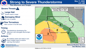
Today: Partly cloudy-to-cloudy, w/scattered showers & thunderstorms (mainly this afternoon). High 77. S @ 10-15.
Tonight: Mo. Cldy w/scatt. shwrs & tstrms. Low 62. S-NW @ 5-10.
Tomorrow: Shwrs ending early; Becoming P/Cldy. High 77. NW @ 10-15.
Thursday: P/Cldy. High 85.
Friday: A chance of morning showers; P/Cldy. High 65.
Monday’s High in Atlantic was 82. Our Low was 46. Last year on this date, the High was 71 and the Low 58. The Record High was 92 in 1908 & 1939. The Record Low was 32 in 1912 & 1973.
Today: Mostly sunny. High 78. W @ 10-15 mph.
Tonight: P/Cldy. Low 54. S @ 5-10.
Tomorrow: P/Cldy to Cldy w/scattered shwrs & tstrms, especially during the afternoon. High 75. SW @ 10-15
Wednesday: P/Cldy w/isolated shwrs & tstrms in the morning. High 78.
Thursday: P/Cldy. High 85.
Sunday’s High in Atlantic was 70. Our Low this morning was 44, and we received .02” of rain Sunday at KJAN. Last year on this date the High in Atlantic was 61 and the Low was 55. The Record High on this date was 93 in 1939. The Record Low was 25 in 1907.
Today: A 50 percent chance of showers and thunderstorms, mainly before 2pm. Cloudy, then gradually becoming mostly sunny, with a high near 67. East northeast wind 5 to 11 mph becoming north northwest in the afternoon. New rainfall amounts between a tenth and quarter of an inch, except higher amounts possible in thunderstorms.
Tonight: Mostly clear, with a low around 49. North northwest wind 5 to 7 mph becoming west after midnight.
Tomorrow:: Sunny, with a high near 78. West wind 5 to 13 mph, with gusts as high as 20 mph.
Tuesday: A chance of showers, with thunderstorms also possible after 4pm. Partly sunny, with a high near 76. Chance of precipitation is 40%. New rainfall amounts of less than a tenth of an inch, except higher amounts possible in thunderstorms.
Wednesday: A slight chance of thunderstorms before 7am. Partly sunny, with a high near 75. Chance of precipitation is 10%.
Saturday’s High in Atlantic was 86. Our Low was 46. Last year on this date, the High in Atlantic was 75 and the Low was 49. The Record High was 91, in 1894 & 2017. The Record Low was 29, in 1929, 1973, & 1983.
Skyscan Forecast Saturday, May 14, 2022 Austin Romer
Today: Sunny with increasing clouds through the day. W @ 15. High 83.
Tonight: Mostly cloudy. NW @ 10. Low 55.
Sunday: Moderate chance of rain and thunderstorms. NE @ 15. High 72.
Sunday Night: Mostly clear. WNW @ 5-10. Low 48.
Monday: Sunny. W @ 10. High 79.
Tuesday: Strong chance of rain and thundershowers in the evening. SE @ 15. High 76.
Yesterday’s high was 80 and the low was 47. This day last year we had a high of 66 and a low of 49. The all-time record high was 97 in 2013. The record low was 29 in 1937. Sunrise is at 6:03 a.m. and sunset is at 8:31 p.m.
(Radio Iowa) – An intense dust storm hit northwest Iowa in the Little Rock area late yesterday (Thursday), causing a temporary black out due to the amount of dust in the air. The word to describe this weather phenomenon was first used in the United States in 1972. “It is pronounced huh-BOOB.” That’s Meteorologist Allan Curtis of the National Weather Service office in Johnston. Fifty years ago, Arizona scientists began using the word to describe the dust storms that swept through the Phoenix area. The National Weather Service uses the term, but Curtis says most Iowans probably haven’t heard it because haboobs are most common in dry, arid regions in the southwest U.S. and western plains.
“Areas where typically in large parts of the year they’re very dry, but they can also get very strong storms that can produce extreme winds,” Curtis says. “…It’s quite rare to get it into what you would call the Corn Belt region just because we’re generally not that dry and even when we are dry, we have corn in the ground, soybeans and whatnot and so there’s less opportunity to kick up that much dust.”

An example of a Haboob dust storm
In the 1930s, the “Dust Bowl” did extreme damage to parts of the Great Plains as clouds of dust swept through the countryside. Curtis says it’s hard to tell with 100 percent certainty if those storms were haboobs, but it’s likely many were. “Given all the stories that we know that have been told from the Dust Bowl and what we are able to glean from that, it was clearly an extremely dry decade, not a lot of things growing, so there was going to be ample opportunity for dry dirt, dust, other types of debris to be picked up and carried around.”
A combination of conditions in northwest Iowa yesterday — a strong thunderstorm with high winds approaching dry, barren cropland — produced the atmosphere for a haboob. Nick Stewart, a meteorologist for K-G-A-N in Cedar Rapids, captured last night’s haboob on camera and posted video of it on Twitter.


